
Sørvágur
|
||

|
||
| position | 62 ° 4 ′ N , 7 ° 18 ′ W | |
|
Resident rank |
1,027 (2009) |
|
| Commune | Sørvágs kommuna | |
| Post Code | FO 380 | |
| Markatal | 48 | |
|
Grammar dative (in / from ...) genitive (after ...) |
í / úr Sørvági |
|

Sørvágur [ ˈsœrvɔavʊr ] ( Danish name : Sørvåg ) is a place on the west side of the island of Vágar , which belongs to the Faroe Islands .
The place
Sørvágur is at the inner end of Sørvágsfjørður . This fjord is also used as an approach lane for the adjacent Vágar Airport . In addition to its importance for the local fishing industry, the seaport of Sørvágur has an important function in ferry traffic with the famous island of Mykines . The Hotel Vágar belongs to the infrastructure of the place as well as good shopping possibilities. The place also has a football club , SÍ Sørvágur . In Sørvágur there is also a small local museum, the Sørvágs Bygdarsavn .
history
The place is said to have been settled around the year 1000 . However, it is assumed that the first settlement courtyard from the time of the conquest of the land was not located in today's town center, which is now between the two waterways Kirkjuá and Stórá , but to the west of Kirkjuá , at a place called Úti undir Skorum . In the 1950s, traces of settlement were found when a new school was built. In the late Middle Ages, the land in and around Sørvágur belonged to the Norwegian noble family Benkenstock. However, around 1665 the family sold the land to the Dane Severin Fohrman, who in turn resold the land to the local population. In this way it came about that almost the entire land was not owned by the king, as elsewhere in the Faroe Islands, but belonged to the local population. However, the place was not very big then. In the middle of the 16th century there were only three farms on site. In the first census in 1801, Sørvágur had 86 inhabitants and 19 houses. But 100 years later, in 1901, there were already 436 residents in 73 houses. During the Second World War , around 5000 Brits were temporarily settled in Sørvágur, who were involved in the construction and operation of the neighboring airport , among other things . In 1953, on the initiative of Dánjal Niclasen, the first fish factory in the Faroe Islands was built in Sørvágur.
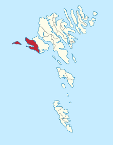
The municipality of Sørvágur
The municipality of Sørvágur (Faroese: Sørvágs kommuna ) has belonged to the villages of Bøur and Gásadalur and the island of Mykines with its small town of the same name since January 1, 2005 . The upstream Holm Tindhólmur is one of them, but is not permanently inhabited.
Personalities
- Jákup í Jákupsstovu (1922–1976), politician.
photos
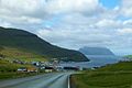
Sørvágur with a view of Mykines to the west

The sandy beach in town

Sørvágur Church

The old school, now a music school
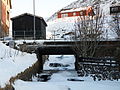
River with bridge

Sørvágur in winter
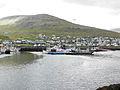
The boat harbor
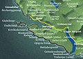
Sørvágur and the surrounding areas


See also
literature
- Sonni Jacobsen: Sørvágur og sørvingar . Forlagið Ytstifjórðingur, Sørvágur 1995–1996, 2 volumes (history of the place, over 1000 pages)
- Excerpt from Volume I (Faroese)
- Extract from Volume II (Faroese)
Web links
- Sørvágs kommuna . Official website of the municipality of Sørvágur
- Sørvágur . Faroeislands.dk (English) information and photos
Individual evidence
- ↑ Í øldum og upphavi , by Sonni Jacobsen, olivant.fo (Faroese)
- ↑ Nakrar Hugleiðingar to Sorvag . olivant.fo (Faroese)
Eiðis | Eystur | Fámjins | Fuglafjarðar | Fugloyar | Hovs | Húsavíkar | Hvalbiar | Hvannasunds | Klaksvíkar | Kunoyar | Kvívíkar | Nes | Porkeris | Runavíkar | Sands | Sjóvar | Skálavíkar | Scopunar | Skúvoyar | Sumbiar | Sunda | Sørvágs | Tórshavnar | Tvøroyrar | Vága | Vágs | Vestmanna | Viðareiðis