Kunoy (place)
Kunoy [ ˈkuːnɪ ] "Women's Island " (Danish: Kunø ) is a place in the Faroe Islands on the island of the same name, Kunoy .

The place Kunoy is the seat of the municipal administration of the Kunoy municipality ( Kunoyar kommuna ), which has existed since 1930 . In September 2016 the place had 69 inhabitants. The zip code is FO-780.
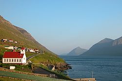
Kunoy is located in the bottom of a trough valley open to the west in the midst of a panorama of mountains over 800 m high. The view over Kalsoyarfjørður to the neighboring island of Kalsoy completes the scenery. The place consists of three parts, whereby the village center is called Heima í Húsi .
The place has around 70 inhabitants and is the only place on the island besides Haraldssund . Together they form the Kunoyar kommuna commune . The two places have been linked by a road tunnel since 1988. Before that, a passenger ferry operated from Strandfaraskip Landsins to Klaksvík .
The only land connection before the tunnel was built was a hiking trail around the southern tip of the island, a little above the shore. The trail still exists today and is relatively easy to walk. Another hiking trail leads over the mountains to the deserted town of Skarð . Because of its height difference of 600 m, it is only suitable for experienced hikers.
Above the village is the small forest ( plantation ) Viðarlundin í Kunoy with a size of 0.78 ha. The first trees were planted here as early as 1914. The forest has been owned by the Kunoy Commune since 1949. There is a café in Kunoy (Kaffistovan í Kunoy).
The church in the village dates from 1867. It was started on May 20th of that year and was finished on October 17th. Everyone involved in the construction was from the island. The builder was a certain Símun Ericsen from Haraldssund, who at that time also built the church of Klaksvík. The church was consecrated on the 1st of Advent 1867. On April 13, 1992, the state government of the Faroe Islands placed the church and its cemetery under a preservation order . However, they are still used.
Another attraction is the small, old water mill in the middle of the village by the Myllá stream . Their roof is covered with grass. The mill was built in such a way that it can serve its purpose even with little water.
Web links
- Faroeislands.dk: Kunoy (in English, info and photos)
Individual evidence
- ↑ Søgu ( Memento of the original from August 15, 2018 in the Internet Archive ) Info: The archive link was inserted automatically and has not yet been checked. Please check the original and archive link according to the instructions and then remove this notice. , kunoy.fo
- ↑ Fólkatal , hagstova.fo
Coordinates: 62 ° 18 ′ N , 6 ° 40 ′ W

