Sørvágsvatn
| Sørvágsvatn , Leitisvatn , Vatnið | ||
|---|---|---|

|
||
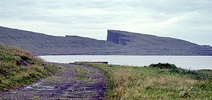
| View along the east bank of the lake to the south to the characteristic peak of the Trælanípa (center) | ||
| Geographical location | Vágar / Faroe Islands | |
| Tributaries | Skjatlá | |
| Drain | Bøsdalaá and then Bøsdalafossur in the North Atlantic | |
| Places on the shore | Vatnsoyrar , Miðvágur | |
| Data | ||
| Coordinates | 62 ° 3 ′ 0 ″ N , 7 ° 14 ′ 0 ″ W | |
|
|
||
| Altitude above sea level | 32 m | |
| surface | 3.56 km² | |
| Maximum depth | 59 m | |
| Middle deep | 27.5 m | |
| Catchment area | 35.2 km² | |
|
particularities |
largest lake in the Faroe Islands |
|
The Sørvágsvatn or Leitisvatn is 3.56 km² the largest lake in the Faroe Islands , located in the south of the island Vágar .
Name (s)
The name is grammatically neuter , since vatn (cf. German: water ) is neuter.
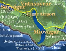
Whether the lake is called Sørvágsvatn or Leitisvatn depends on where the locals stand. On the west bank it is called Sørvágsvatn, but on the east bank it is Leitisvatn. This peculiarity is best remembered when you consider that the place Sørvágur is west of the lake. Exactly in the middle of the lake runs the municipal border to Miðvágur in the east. Therefore, more precise maps show both names on the respective side of the border.
Popularly, however, the body of water is simply called Vatnið (the lake).
geography
Sørvágsvatn / Leitisvatn is 32 meters above sea level in the south of the island of Vágar . The lake extends from north to south over a length of about 6 kilometers and is a maximum of 800 meters wide. At 59 meters deep, it is also the deepest lake in the Faroe Islands.
In the south it is drained into the North Atlantic by the brook Bøsdalaá and the subsequent waterfall Bøsdalafossur . This fact leads to the impression that on some (overview) maps the lake has access to (or from) the sea and is therefore a kind of fjord. However, the Bøsdalafossur plunges 32 meters vertically into the sea. The Trælanípa cliff is also located on this south coast .
On the opposite north bank of the lake is the place Vatnsoyrar . This location makes it the only inland town in the Faroe Islands. At the same time, the only sandy beach on the lake is located here, while the rest of the shore is stony.
Leisure and Tourism
A hiking trail runs along both banks of the lake. If you want to go around the lake in the south, you need rubber boots, even if there is a kind of path made of individual stones on which you can cross the Bøsdalaá. This relatively easy tour is rewarded with a view of Koltur , Hestur , Sandoy , Skúvoy and, if the visibility is good, also of Suðuroy .
This corner of the Faroe Islands is considered to be one of the most scenic, as you have almost all typical Faroese landforms in one place: the lake, the stream, the waterfall, the sea; flat pastures and grassy mountain slopes; flat cliff beach and rugged cliffs; freestanding rock pillars and skerries; paired with birds, plants, sheep and often seals.
Appropriate tours can be organized on site for equestrian enthusiasts. The Hotel Vágar is located in the immediate vicinity of both Vágar Airport and the lake. The road 40 leads along a section directly on the north east bank.
The fish-rich lake is an attractive area for anglers. Arctic char and Faroese trout ( Salmo trutta faroensis ) are particularly common here. You can also fish from boats here. Fishing licenses can be purchased from the Kunningarstova Vágar tourist information office in Miðvágur . See also : Fishing in the Faroe Islands .
Since summer 2005 , tourist tours by converted motorboat have been offered on the lake for the first time. The almost three-hour tour goes over the entire length of the lake to the waterfall, where you have an hour shore leave before fishing on the way back.
Story (noun)
When the Faroe Islands were occupied by Great Britain during World War II , the lake was used as an airfield for seaplanes . Soon after, Vágar Airport was built on its west bank .
At noon on March 24, 2005 , this seaplane tradition was to be revived when a US private plane wanted to make a stopover at Vágar airport on the way from Norway home, but did not extend its landing gear. When he reported to the tower that it was an aircraft with floats, the Faroese air traffic control directed him to ditch the Vatn (á Vatninum). The aircraft was then towed ashore for repairs in a rubber dinghy from the airport service. Neither people nor the aircraft were harmed. After the undercarriage had been repaired improvised with jacks on the bank, the aircraft was refueled and left the Faroe Islands as it had come: on the Vatn.
literature
- Frank Landkildehus, Erik Jeppesen, Jens Peder Jensen and S. í Dali: "General Description of Five Faroese Lakes" in: Ann. Soc. Scient. Færoensis Suppl. 36. 2002: 28–33 PDF ( Memento from June 11, 2007 in the Internet Archive ) (374 KiB )
Web links
- Lakeside.fo (so far only in Faroese)
-
Beginning of Frederiksen's homepage (aerial photo from the southeast)
- Same website (aerial photo of the waterfall)
-
Karlsöguidernas vänförening - Färöarna 12 - 18 July 2004 (the waterfall up close)
- Same website (view along the east coast to the south)
- Portal.fo, March 24, 2005 - Neyðlendi á Vatninum (in Faroese. Press release on the emergency landing on March 24, 2005. Photo)
- Portal.fo, March 31, 2005 - Ferðafólkasigling á Vatninum (in Faroese: "Boat tours for tourists on the Vatnið". Photo)


