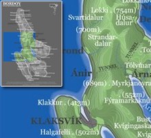
Ánir
Ánirnar [ ˈɔanɪɹnaɹ ] (until 2011 Ánir ) [ ˈɔanɪɹ ] ( Danish : Åerne ) is a small town in the Faroe Islands on the north island of Borðoy .
- Population: 24 (January 1, 2011)
- Postal code: FO-726
- Municipality : Klaksvíkar kommuna
The Faroese word ánir is a rare variant of vánir and means “forecasts, prospects, hopes”.
Ánir is located north of the North Island metropolis Klaksvík on the west coast of Borðoy and was founded in 1840 because new land had to be developed due to the population growth. Opposite the place is the southern tip of the island Kunoy .
Ánir has a modern port that extends the Klaksvík port. In addition to freight traffic and fishing, it also serves as a port of departure for the overseas ferry Norröna . Since October 3, 2007 it has been called Norðhavnin ("the northern harbor").
Web links
- Faroeislands.dk: Ánir (in English, info. And photos)
Individual evidence
- ↑ Landsverk broytir bygdaskelti ( Memento from May 10, 2016 in the Internet Archive ), landsverk.fo, Jan. 20, 2011
- ↑ portal.fo : Nú eitur havnin í Ánunum Norðhavnin ( Memento from April 15, 2012 in the Internet Archive ) (“Now the port in Ánir Norðhavnin”), October 4, 2007
Coordinates: 62 ° 15 ′ N , 6 ° 35 ′ W


