
Volksgarten (Leipzig)
| Volksgarten | |
|---|---|
|
|
|

|
|
| Playground axis with rows of linden trees | |
| Basic data | |
| place | Leipzig |
| District | Schönefeld East |
| Created | 1895 |
| Surrounding streets | Torgauer Strasse, Volksgartenstrasse |
| Technical specifications | |
| Parking area | 3.6 ha |
The Volksgarten (also Volksgarten Sellerhausen ) is an urban park in the northeast of Leipzig . It is a listed building .
location
The Volksgarten is located on the northwest side of Torgauer Straße, north of the railway bridge of the Leipzig Hbf – Leipzig-Connewitz railway line, which was closed in 2012 . It is bounded in the south by the railway area and in the west and northwest by the allotment garden association Nordostvorstadt . In the northeast, it is closed off by Volksgartenstrasse, which is closed to through traffic. There are access to the park in Torgauer and Volksgartenstraße.
Most of the area belongs to the Sellerhausen district, which is why the name Volksgarten Sellerhausen is in use. With the municipal division of the city in 1992, the Volksgarten became part of the Schönefeld-Ost district.
history
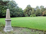
In 1893, the city of Leipzig acquired approximately two hectares of land from a former sand pit on Torgauer Strasse. In the same year, the Leipzig council gardener Otto Wittenberg (1834–1918) suggested converting the site into a park, as there were no green spaces as recreational areas for the residents of the increasing tenements in the east of the city. He developed the plans for a smaller park than it exists today, and which also includes Apelstein No. 41 from 1863. The Volksgarten was finished in 1895 and opened at Pentecost.
Wittenberg rejected an extension of the park to the west requested by the house owners' association of the eastern districts in 1899. Instead, in 1907, under his successor Carl Hampel (1849–1930), the park was enlarged to the east as far as Volksgartenstrasse. The park gained further importance in the 1970s with the construction of the new Schönefeld complex, which was followed by a small extension along Volksgartenstrasse to the north.
description
Apelstein and Wiese
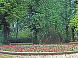
Rose rondel

playground


If you enter the park from Torgauer Straße, you first come across Apelstein No. 41, which marks the position of the left wing of the French army, commanded by Marshal Michel Ney (1769–1815), in the Battle of Leipzig on October 18, 1813. Behind it, a large meadow spreads out, which is designated as a free-range location for dogs.
At the top there is a rose ring and a children's playground surrounded by trees. The rose rondel is laid out in a basin about ten meters in diameter, which was previously filled with water and contained a fountain. The central play device on the children's playground is a climbing net. Curved paths with a few benches run through the park. The trees, especially linden, oak, chestnut and hawthorn come from almost all decades of the last century. Dense bush plantings shield the park from the busy Torgauer Straße.
literature
- Petra Mewes, Peter Benecken: Leipzig's Green - A Park and Garden Guide . Passage-Verlag, Leipzig 2013, ISBN 978-3-938543-49-8 , pp. 172/173 .
Web links
Individual evidence
- ↑ List entry. In: Cultural monuments in the Free State of Saxony. Retrieved August 7, 2020 .
- ↑ Free-range locations for dogs. In: Website of the city of Leipzig. Retrieved August 7, 2020 .
- ↑ "Volksgarten" playground. In: Website of the city of Leipzig. Retrieved August 7, 2020 .
- ^ Official city map of Leipzig. In: Website of the city of Leipzig. Retrieved on August 7, 2020 (level: call park, cemetery and street trees ).
Coordinates: 51 ° 21 ′ 0 ″ N , 12 ° 25 ′ 16 ″ E