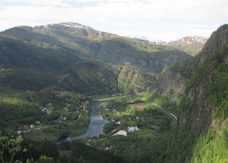
Vosso
|
Vosso Bolstadelva |
||
|
Vosso near Bolstad |
||
| Data | ||
| Water code | NO : 062.Z | |
| location | Vestland ( Norway ) | |
| River system | Vosso | |
| Drain over | Vosso → North Sea | |
| confluence | of Raundalselva and Strandaelva 60 ° 37 '50 " N , 6 ° 25' 51" O |
|
| muzzle | in the Bolstadfjord ( Veafjord ) coordinates: 60 ° 38 '26 " N , 5 ° 57' 2" O 60 ° 38 '26 " N , 5 ° 57' 2" O |
|
| Mouth height |
0 m
|
|
| Catchment area | 1497 km² | |
| Flowing lakes | Vangsvatnet , Evangervatnet | |
| Small towns | Vossvangen | |
| Communities | Bolstadøyri | |
|
Outflow from the Evangervatnet |
||
The Vosso is a river and river system in the Norwegian province of Vestland .
It arises from the confluence of the Raundalselva and Strandaelva near Vossevangen in the municipality of Voss . It then flows through Lake Vangsvatnet and continues to Lake Evangervatnet to the west . This he leaves as Bolstadelva and continues to flow westward and flows Bolstadøyri in Bolstadfjord , a fjord arm of Veafjord .
The catchment area covers 1497 km².
Web links
- Vosso on Norgeskart.no

