
Woehrsee
| Woehrsee | ||
|---|---|---|

|
||
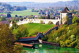
| Orthophoto of the Wöhrsee | ||
| Geographical location | Bavaria , Germany | |
| Tributaries | St. Johannser Bach | |
| Drain | Wöhrbach → Salzach → Inn → Danube → Black Sea | |
| Places on the shore | Burghausen | |
| Data | ||
| Coordinates | 48 ° 9 '38 " N , 12 ° 49' 44" E | |
|
||
| Altitude above sea level | 360.7 m above sea level NN | |
| surface | 9.4 ha | |
| length | 910 m | |
| width | 100 m | |
| volume | 218,000 m³ | |
| scope | 2.06 km | |
| Maximum depth | 3.7 m | |
| Middle deep | 2.3 m | |
| Catchment area | 6 km² | |

The Wöhrsee is a swimming lake in the town of Burghausen in the Altötting district in Bavaria .
Emergence
The Salzach , which runs to the northeast at this point, used to have a loop to the northeast, which was cut by shifting the river bed to the south. What remained was a fairly flat circular mountain and a left oxbow lake in which the St. Johannser Bach, which was created a little upstream from the loop next to it, ran to the Salzach. The Burghausen castle was built on the downward southern spur above its mouth and the oxbow river was dammed for defense. The water flowing out of it now reaches the nearby Salzach via the short Wöhrbach on a twisted course through the old town under the Spornspitze.
History of use
In 1332 the waters of today's Wöhrsee were first mentioned in a document as "Wur". In addition to its function as part of the castle's defensive structure, the Wöhrsee was also used by the ducal court mill in the Middle Ages. It was used as a fishing water and ice supplier. The mineral-rich water from a spring in the north of the Wöhrsee basin, today called "Herzogsbad", was used for healing and recovery during the time of Duchess Hedwig . A garrison swimming school was operated at Wöhrsee from the 19th century . Since 1833 the citizens of Burghausen have been allowed to swim there. After the water was temporarily in private ownership after the garrison left in 1891, the city acquired the Hofmühle with the Wöhrsee in 1901. Sea festivals were held regularly from 1913 to 1957. The previously separate bathing establishments for women and men were opened in 1934/1935 as the Wöhrsee family pool.
In January 2015, the first German ice swimming championship took place in the natural swimming pool Wöhrsee on established lanes with a length of 25 meters .
Wöhrsee and the adjacent Burgberg in the east as well as the Spitalfeld in the west are now part of the Salzachtal conservation area .
photos

Wöhrsee from the Burghausen castle
Wöhrseebad and Powder Tower
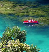
Strong aquatic plant growth in summer

Herzogsbad


Individual evidence
- ↑ a b c d e f g h i Wöhrsee water portrait , Traunstein Water Management Office, accessed on January 27, 2014
- ↑ Bavaria Atlas of the Bavarian State Government ( notes )
- ↑ Google Maps apparently shows the wrong course of the Wöhrbach with an estuary too far downstream. According to the orthophotos of the Bayern Atlas, this is probably on the south deck of the old town, where Kapuzinergasse and Salzlände converge.
- ^ History of Wöhrsee ( Memento from February 3, 2014 in the Internet Archive ), Bäder Burghausen
- ^ Environment Office of the City of Burghausen: The history of the Wöhrsee; Information board by the lake .
- ↑ Eischwimmen in Burghausen: Our reporter at the 1st Ice Swimming German Open ( Memento from December 29, 2015 in the Internet Archive ), B5 currently from January 23, 2015, accessed on December 29, 2015.
- ↑ Map service for protected areas in Germany , Federal Agency for Nature Conservation
- ↑ LSG-00289.01 (see also list of landscape protection areas in Bavaria )
Web links
- Wöhrsee , RegioWiki Niederbayern & Altötting
- Bathing water quality , Altötting district office