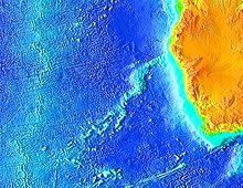
Whale back
The Whale Ridge ( English Walvis Ridge ) is a steep mid-ocean ridge in the South Atlantic with a length of around 3000 kilometers. The ridge rises from more than 5,000 m water depth in several places to less than 200 m below the water surface. It lies between the coast of South West Africa ( Walvis Bay , Namibia ) and the volcanic island group Tristan da Cunha , where it connects with the Mid-Atlantic Ridge .
The Walvis Ridge separates the Angola Basin from the Cape Basin - both deep sea basins, reaching depths of over 5,000 meters.
According to today's conception, the whale ridge was created either by activities of a transform fault or from magma that was produced by hotspots of the Tristan da Cunha volcano. As the plates drifted apart, this magma migrated eastward with the African plate .
The Rio Grande Ridge is a mirror image of the Whale Ridge on the western side of the Mid-Atlantic Ridge .
Individual evidence
- ^ A b Claudia Wenzel: Geochemical Signals in Late Pleistocene Deep Sea Sediments from the Northern Benguela Current System: Indicators for Paleoclimatic and Paleo-Oceanographic Conditions . 2004, p. 3 ff . ( d-nb.info - dissertation University of Oldenburg).
- ↑ Middle Cretaceous sediments from the eastern part of Walvis Ridge . Nature . Retrieved November 6, 2009.
