Wallburg Dassel
| Wallburg Dassel | ||
|---|---|---|
|
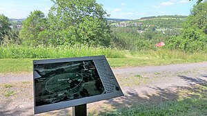
Information board on the castle hill; on the right in the background the Bierberg |
||
| Creation time : | Early medieval | |
| Castle type : | Höhenburg, hillside location | |
| Conservation status: | Burgstall, Wall | |
| Place: | The same | |
| Geographical location | 51 ° 47 '36.3 " N , 9 ° 41' 52.5" E | |
|
|
||
The Wallburg Dassel is an early medieval castle wall on the castle hill near Dassel . The complex was probably used by the Counts of Dassel as the forerunner of their Hunnesrück Castle .
location
The disused facility is located south of the city center on the right bank of the Ilme . There is an abandoned quarry nearby. Exact data was recorded using airborne laser scanning .
investment
The diameter of the hillside castle is between 90 and 100 meters. A trench up to 20 m wide is upstream. The wall has been preserved in the east. According to ceramic finds, the castle is dated to the early Middle Ages. The ground monument is now used as pasture.
Individual evidence
- ^ Hans-Wilhelm Heine : Airborne laser scanning in the Weserbergland. In: Reports on the preservation of monuments in Lower Saxony . Vol. 29, No. 4, 2009, pp. 135-137

