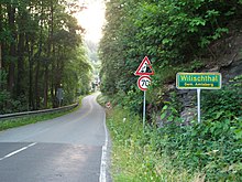
Wilischthal
Wilischthal describes a settlement in the Wilisch valley in the Erzgebirge district in Saxony, which now consists of districts of three political communities.
Until December 31, 1993 (formation of the municipality of Amtsberg) this belonged to four municipalities: Schlösschen, Weißbach, Grießbach and Zschopau.
So there is now one district of Wilischthal in the
- City of Zschopau (middle part east of the confluence of the Wilisch in the Zschopau with the Wilischthal train station and the one with the former wire and spring factory (Plant I and Plant II)). Wilischthal has a stop at the Zschopautalbahn (Flöha – Vejprty). From 1886 to 1972 Wilischthal was also the starting point for the Wilischthal – Thum narrow-gauge railway .
- Municipality of Amtsberg (northern part of the Wilisch with the "Villa Wilisch").
The district, which previously belonged to the municipality of Schlößchen , was created in 1792 from an oil and grinding mill belonging to the Porschendorf manor, the Schlösselmühle , on the banks of the Wilisch. This was later included in the Wilischthal paper mill, which was producing until 1995 and has since been demolished.
Now the district that previously belonged to the municipality of Weißbach opposite the "Villa Wilisch" with the former spinning mill (founded in 1861) belonged to the municipality of Amtsberg. - Drebach municipality (southern part west of the Zschopau with the former cutting mill. Before 1998 this was a district of Grießbach , then until 2004 a district of Venusberg .
See also : Wilischthal satellite camp
Web links
Commons : Wilischthal - Collection of images, videos and audio files
- Wilischthal in the Digital Historical Directory of Saxony (only the part belonging to Zschopau)
- Wilischthal district of the city of Zschopau
- Wilischthal district of the municipality of Amtsberg
- Wilischthal district of the Drebach community
Individual evidence
- ↑ cf. The middle Zschopau area (= values of our homeland . Volume 28). 1st edition. Akademie Verlag, Berlin 1977, pp. 152–153.
- ↑ a b Willischthal. In: amtsberg.eu. Municipal administration Amtsberg (responsible for the website is the Heimatverein), accessed on November 23, 2017 .
Coordinates: 50 ° 44 ' N , 13 ° 3' E


