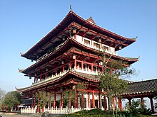
Wuling (Changde)
The municipality of Wuling ( 武陵区 , Wǔlíng Qū ) is a municipality in the prefecture-level city of Changde in the north of the Chinese province of Hunan . It has an area of 289 square kilometers, of which around 90 square kilometers are urban areas, and in 2013 had a population of around 600,000. It is the center and seat of government of Changde, the northern area of which it represents. Its origins are traced back to Zhang Ruo , who headed the Shu Commandantium 2,200 years ago and founded a city called Zhangruo Cheng.
geography
Wuling is located on the lower reaches of the Yuan River and in the subtropical climate zone . The annual average temperatures are between 16.5 ° C and 17.5 ° C, the annual precipitation is around 1400 mm. The relative humidity is between 68% and 89%. In the winter half-year the wind tends to blow from the north, in the summer half-year it tends to blow from the south.
The relief is flat to hilly, the highest peaks are with the Hefu mountain in the west of the district area. It is located west of Dongting Lake , with the main bodies of water in the territory of the municipality being Baima Lake , Liuye Lake , Chuanzi River , Sanlü River and Yinyuan River . A 17.3 kilometer long canal surrounds the city and connects all bodies of water.
Administrative structure
At the community level, the district has been made up of eleven street districts , one large municipality and two municipalities since the regional reform of 2014 . These are:
- Furong Street (芙蓉 街道)
- Road quarter Qiming (启明街道)
- Fuping street district (府 坪 街道)
- Chuanzihe Street District (穿 紫 河 街道)
- Zhilan Street District (芷兰 街道)
- Road quarter Danyang (丹阳街道)
- Baimahu Street District (白马湖 街道)
- Road quarter Dongjiang (东江街道)
- Yong'an Street District (永安 街道)
- Nanpinggang Street District (南坪 街道)
- Changgeng Street District (长庚 街道)
- Greater community Hefu (河洑镇)
- Community Ludishan (芦荻山乡)
- Danzhou Township (丹 洲 乡).
traffic
Since ancient times, Wuling has been at a crossroads where trade between North and South China and East and West China met. The Changsha – Zhangjiajie Highway and the 207 and 319 National Roads now touch the Wuling territory . It is also on the Shimen – Changsha railway line . The Chongqing – Changde high-speed line , which is currently under construction, will shorten the travel time to Chongqing to two hours. The closest airport is Changde Taohuayuan Airport , which offers connections to the main Chinese cities.
Web links
Individual evidence
- ↑ a b 自然环境.武陵区 人民政府 办公室, accessed April 7, 2019 (Chinese).
- ↑ 武陵区 概况 地图.行政 区划 网站, February 5, 2016, accessed April 7, 2019 (Chinese).
- ↑ a b c 武陵 概况.武陵区 人民政府 办公室, accessed April 7, 2019 (Chinese).
Coordinates: 29 ° 2 ' N , 111 ° 42' E

