
Wutzsee (Lindow)
| Wutzsee | ||
|---|---|---|

|
||
| Wutzsee 2007 | ||
| Geographical location | Germany , Brandenburg , Ostprignitz-Ruppin district | |
| Tributaries | Lindower Rhin | |
| Drain | Lindower Stadtfließ | |
| Places on the shore | Lindow (Mark) | |
| Data | ||
| Coordinates | 52 ° 58 ′ 15 ″ N , 13 ° 0 ′ 31 ″ E | |
|
||
| Altitude above sea level | 40.2 m above sea level NHN | |
| surface | 90 ha | |
| length | 2.88 km | |
| width | 550 m | |
| Maximum depth | 18 m | |
|
particularities |
Rinnensee |
|

The Wutzsee is a channel lake up to 18 meters deep on the outskirts of the town of Lindow (Mark) in the Ostprignitz-Ruppin district . Its area is 90 hectares. The outflow of the lake, the Lindower Stadtfließ, drove the monastery mill, which was mentioned in 1530. This runoff also connects the lake with the neighboring Gudelacksee . Driving on the lake with motor boats is prohibited.
The lake is surrounded by a well-marked hiking trail, most of which is about five meters above the water level. A hike around the lake takes two to three hours; the path is lined with many benches.
The nearby original Cistercian convent Lindow , a women's monastery until 1945 , is a place of action in Theodor Fontane's novel Der Stechlin as Kloster Wutz .
See also
Web links

The Wutzsee (2005) from the monastery

Riverside path on the Wutzsee

boggy banks on the Wutzsee

Swan family at the Wutzsee. View of the monastery area
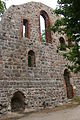
Ruins of the Cistercian monastery on the Wutzsee


