Wuvulu
| Wuvulu | ||
|---|---|---|
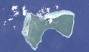
| NASA satellite image from Wuvulu | ||
| Waters | Pacific Ocean | |
| Archipelago |
Bismarck Archipelago ( Western Islands ) |
|
| Geographical location | 1 ° 43 ′ 0 ″ S , 142 ° 50 ′ 0 ″ E | |
|
|
||
| length | 7.2 km | |
| width | 4 km | |
| surface | 14 km² | |
| Highest elevation | 3 m | |
| Residents | 824 (2000) 59 inhabitants / km² |
|
| main place | Auna Village | |
| Map of the Western Islands of the Bismarck Archipelago, with Wuvulu in the far west (far left) | ||
Wuvulu (German outdated: Tiger Island ) is an island of the Western Islands of the Bismarck Archipelago . Administratively, the island belongs to the Manus Province in Papua New Guinea .
geography
Wuvulu is the westernmost island of the Bismarck Archipelago and is 416 km from the main island of Manus . The island of New Guinea is located approx. 260 km to the south. The 14 km² island of volcanic origin reaches a maximum height of 3 meters above sea level and is surrounded by a coral reef .
climate
The average temperature is between 21 and 35 degrees Celsius. The annual rainfall is between 200 and 300 cm. Wuvulu is outside the Pacific Cyclone Zone.
population
The 824 inhabitants as of the 2000 census are distributed among the villages of Aunna (Auna) in the southwest (396) and Onne in the northwest (428). Fishing and subsistence farming form the basis of nutrition . There are cassava , taro and sweet potatoes grown.
traffic
There is an airfield on Wuvulu, IATA airport code : WUV .
The island is visited by cruise ships from time to time .
swell
Individual evidence
- ↑ German Colonial Lexicon. Edited by Heinrich Schnee. - Leipzig: Quelle & Meyer 1920. - 3 vols.
Web links
- Travel report with pictures ( Memento from October 7, 2011 in the Internet Archive )
- Description of the island (Engl.) With images ( Memento of 20 November 2008 at the Internet Archive )


