
Zamami-jima
| Zamami-jima | ||
|---|---|---|
| Waters | East China Sea | |
| Archipelago | Kerama Islands , Ryūkyū Islands | |
| Geographical location | 26 ° 14 '4 " N , 127 ° 18' 27" E | |
|
||
| length | 5.2 km | |
| surface | 6.7 km² | |
| Highest elevation | Ufudaki 160.7 m |
|
| Residents | 582 (January 1, 2015) 87 inhabitants / km² |
|
| main place | Zamami | |

Zamami-jima ( Japanese 座 間 味 島 ) is an island in the group of Ryūkyū Islands in the Pacific.
geography
Zamami-jima has an area of 6.70 km² and 582 inhabitants in 321 households (as of January 1, 2015). The island belongs to the same community Zamami of Okinawa Prefecture .
history
Zamami is believed to be the first landing point for US forces during World War II .
tourism
Today the population of Zamami lives mainly from fishing and various water sports for tourists. Diving, snorkeling and whale watching are popular. Zamami also has beaches such as B. Kozamami Beach, which is ideal as a starting point for a diving or snorkeling excursion.
There are several daily ferry connections between Zamami-jima and the city of Naha on the main island of Okinawa.
gallery

Ama beach
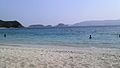
Furuzamami beach


Web links
Individual evidence
- ↑ a b 指定 離島 ・ 指定 離島 一 覧 . (PDF) In: 離島 関係 資料 (平 成 28 年 1 月) . 沖 縄 県 企 画 部 地域 ・ 離島 課 ("Land and Islands Unit, Planning Department, Okinawa Prefecture"), January 2016, p. 1 , accessed on 3. August 2016 (Japanese).