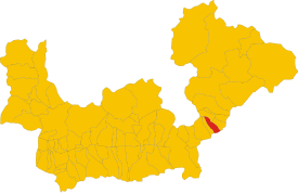
Lovero
| Lovero | ||
|---|---|---|

|
|
|
| Country | Italy | |
| region | Lombardy | |
| province | Sondrio (SO) | |
| Local name | Lueer | |
| Coordinates | 46 ° 14 ' N , 10 ° 14' E | |
| height | 515 m slm | |
| surface | 13.4 km² | |
| Residents | 630 (December 31, 2019) | |
| Population density | 47 inhabitants / km² | |
| Post Code | 23030 | |
| prefix | 0342 | |
| ISTAT number | 014038 | |
| Popular name | Loveresi | |
| Patron saint | Alexander of Bergamo ( August 26 ) | |
| Website | Lovero | |
Lovero is a municipality ( comune ) in the northern Italian province of Sondrio in Lombardy with 630 inhabitants (as of December 31, 2019).
geography
The municipality is located about 15 kilometers east-northeast of Sondrio on the Adda in the Valtellina and borders directly on the province of Brescia . The neighboring municipalities are Edolo (BS), Sernio , Tovo di Sant'Agata and Vervio .
traffic
Strada Statale 38 dello Stelvio leads through the municipality from Piantedo to Bozen .
Attractions
- Sanctuary of Madonna delle Grazie with portal (1590) and frescoes in the interior by Giovan Battista Muttoni from Cima, fraction of Porlezza and remarkable carved wood works by Giovan Battista Del Piaz.
literature
- Anna Ferrari-Bravo, Paola Colombini: Guida d'Italia. Lombardia (esclusa Milano). Milano 1987, p. 391.
- Lombardia - Touring club italiano, Touring Editore (1999), ISBN 88-365-1325-5 , Lovero Online
- Lovero on tuttitalia.it/lombardia
Web links
Commons : Lovero - collection of pictures, videos and audio files
Individual evidence
- ↑ Statistiche demografiche ISTAT. Monthly population statistics of the Istituto Nazionale di Statistica , as of December 31 of 2019.


