
Manslagt
|
Manslagt
Krummhörn municipality
|
|
|---|---|
 |
|
| Height : | 1 (-0.5-1.0) m |
| Area : | 8.65 km² |
| Residents : | 410 (December 31, 2012) |
| Population density : | 47 inhabitants / km² |
| Incorporation : | July 1, 1972 |
| Postal code : | 26736 |
| Area code : | 04923 |
The village of Manslagt was an independent municipality until the Lower Saxony municipal reform. Today it belongs to the East Frisian municipality of Krummhörn . Manslagt lies between Pilsum in the north and Groothusen in the south. Manslagt's settlement history goes back to the early Middle Ages . The place has about 400 inhabitants.
geography


Manslagt is surrounded by five Krummhörner villages. In the north it borders on Pilsum, which has a 13th century church with a crossing tower , which is unique for the region . Visquard is on the eastern border of Manslagt . The former monasteries Appingen and Dykhusen are located in the municipality of this village . In the south, Manslagt borders on Woquard , the Langwurtendorf Groothusen with its Osterburg and Hamswehrum .
Manslagt was built as an "elongated, round warf settlement " in the former Sielmönker Bay . Archaeological drilling revealed that the terp is located on a former island. The dimensions of the Manslagter Dorfwarft are 6 meters in height, 480 meters in length and 280 meters in width. The entire area of the village yard, which is enclosed by a road, the Manslagter Ring , is around ten hectares. In ancient times, Manslagt was surrounded by the bow , which is still remembered today by a street name. The Bugel was originally the continuation of the Pewsumer Ehe watercourse , which flowed seaward. The Bugel was probably the last outflow from the silting Sielmönker Bay. Remains of an old dike can also be seen near Manslagt. They are under the street Hoher Weg .
The inner path network of Manslagt has - in contrast to the round village of Rysum - a chessboard-like character. The twelve (partly former) farms are located in a circle on the slope of the terp. The core of the settlement is formed by non-rural houses. In the center of the village is the Manslagter church with the separately erected bell tower and the surrounding cemetery. Several fethings , which have an elongated, curved shape, served the village water supply until the 20th century.
To the east of the core village is the Manslagter settlement , which was laid out in the 1920s and expanded after 1950 . It is located on the former site of the Eschenhof residential area . The Swietershausen settlement was also laid out from the middle of the 20th century . Further residential areas belonging to Manslagt are Groß Horenburg , Klein Horenburg , Platthaus and Strohburg .
Manslagt also has a stretch of coast of the Lower Saxony Wadden Sea . It is located around two kilometers from the village center and can be reached via several paved paths. In front of the coastal section is the so-called Manslagter Nacken , a salt marsh area that belongs to Zone I of the Lower Saxony Wadden Sea National Park and can only be entered in a few areas all year round, for example on marked paths or as part of guided mudflat hikes .
history
.jpg)
Manslagt was first mentioned around the year 1000 in goods and lifting registers the Abbey Werden Abbey . In these oldest documents, the name Manslagts is "Marsfliati" and "Marslati", from 1361 "Mansliacht". On the Ubbo-Emmius map of East Frisia (see picture), which was made around 1600, you can find the spelling Manslacht . Other spellings - as in the Münster parish register of the 15th century - call the place "Manslat" or "Manslach".
Local researcher Otto Galama Houtrouw derives the name Manslagt from manslecht - which means something like "murder". Arend Remmers assumes, however, that despite the similarity of the place name to the old Frisian words mannslachta ("manslaughter") or (reconstructed) mānsliacht ("moonlight", see the crescent moon in the coat of arms) these interpretations are out of the question. He leads the place name back to the Middle Low German word slacht for "bank reinforcement " or "pile work". In connection with the old Frisian mân or East Frisian-Low German mande for "community", "cooperative" the name would mean something like "community bank fortification".
Manslagt later belonged to the Beninga chief family . When the heiress Gela von Manslagt married Enno von Greetsiel , the area fell to the Cirksena family and was later diked. To the west of the village stood a castle in the second half of the 14th century, which belonged to the family estate of the extensive Beninga family.
During the Thirty Years' War , mercenary troops of Count Ernst von Mansfeld reached the Krummhörn in November 1620 and ruled there for fourteen months. After their withdrawal, which was accompanied by looting and pillage, the troops of the cavalry regiment of Ringgrave Ludwig Wilts followed in January 1623, who proceeded in a similar way with the Krummhorns. In August of the same year the Mansfeld mercenaries returned and, among other things, lodged in Manslagt, slaughtered the cattle that were still there and consumed the last supplies of the residents. 130 people died of a plague that occurred in the Krummhörner village at that time. But the Mansfeld troops were also weakened. Around a third of the soldiers in Manslagt, Pilsum and Greetsiel lost their lives due to hunger and the disease mentioned above. In January 1624 they withdrew.
In addition to agriculture, Manslagt was shaped by numerous craft businesses in the past. A register of residents from 1719 shows a brewer , a copper maker and a village boatman, two bricklayers , blacksmiths , tailors and carpenters . There were three craft workshops each: cobblers , bakers and weavers . Around 160 years later, in addition to Kuper, Schmied and Schneider, two innkeepers, two merchants, three bakers and five boatmen each were registered. Around 1824, Fridrich Arends describes in his description of the earth of the Principality of East Friesland and the Harlingerland "Manslagt [as a] large village [...] which has 498 inhabitants". According to his presentation, it is one of the five villages of the Greetsieler Amt that have the best arable land.
Almost 500 inhabitants lived in Manslagt at the beginning of the 20th century. On September 21, 1906, Manslagt was given a railway connection and station building. The reason was the extension of the small railway line from Emden to Pewsum, which opened on July 27, 1899 . This extension was requested by the Manslagter Council on March 3, 1900 at the district of Emden . After a lengthy approval process, construction work on the meter- gauge small railway began in 1905 . In 1906 it was able to start operating under the name Kreisbahn Emden – Pewsum – Greetsiel (popularly Jan Klein ). The extended route led from Pewsum via Groothusen, Manslagt and Pilsum to Greetsiel. In 1963 the train connection was discontinued. Kraftpost took over the passenger transport .
In April 1919 there were so-called "bacon removals" from Emden workers, which were followed by rioting on the farm workers. Together with the Rheiderland , the district of Emden was the part of East Frisia most affected by this unrest. Workers broke into the surrounding villages in closed trains and stole food from farmers in clashes. The situation only calmed down after the deployment of the Reichswehr troops stationed in the region . As a reaction to this, resident groups were formed in almost all villages in the Emden area . Manslagt's resident defense comprised 70 people, making it one of the strongest in the district of Emden. These had 20 weapons. The resident services were only dissolved after a corresponding decree by the Prussian interior minister Carl Severing on April 10, 1920. In 1928 the Manslagter fire service was founded . It maintained its independence as a local association until it merged with the Pilsumer Wehr in 2006.
For centuries, the natural depths and drainage channels that crisscross the Krummhörn in a dense network have been the most important modes of transport. Not only the villages but also many farms were connected to the city of Emden and the port of Greetsiel via ditches and canals. The boat traffic with Emden was particularly important. Village boatmen took over the supply of goods from the city and delivered agricultural products in the opposite direction: “From the Sielhafenort, smaller ships, so-called Loog ships, transported the cargo to the inland and supplied the marsh villages (loog = village). The loog ships from the Krummhörn enlivened the canals of the city of Emden until the 20th century. "
Peat, which was mostly extracted in the East Frisian Fehnen , played an important role as heating material for the inhabitants of the Krummhörn for centuries . The peat ships brought the material along the East Frisian canal network to the Krummhörn villages, including Manslagt. On their way back into the Fehnsiedlungen the Torfschiffer often took clay soil from the march and the manure of cattle with which they their home were dug fertilized land.
Until the 1930s, village shipping on the Krummhorn waterway network played an important role in the transport sector in Manslagt. The manslagter Daniel Schmeda reports in his memoirs: “In August / September the boatmen came from the Fehnen and brought peat. It was the peat boatmen Köster, Ottersberg and Wilm Meinen. Most of them arrived in the afternoon. The ship's freight, 20–22 pounds , were mostly booked in advance. "
Whether there were residents of Jewish origin before the start of National Socialism cannot yet be proven. In Schmeda's memoirs, however, there is talk of foreign Jewish cattle traders who had business connections with Manslagt farmers. He mentions the names Seligmann, Snurtje Pels, Visser and Schönthal.
In the elections at the beginning of the 1930s, the proportion of votes for the National Socialist Party in Manslagt grew by leaps and bounds. By 1938 at the latest there was a local branch of the NSDAP, which was part of the NSDAP district association Norden-Krummhörn under the leadership of Woltzetener Lenhard Everwien . During the Second World War there was a prisoner-of-war camp in the village that was called Alte Schmiede and was run under the name AK No. 1164c . Twenty French people were housed there in October 1940. The memorial to the fallen, which is located on the Manslagt bell tower, bears the names of 49 Manslagt soldiers who fell in World War II.
Like many other places in East Frisia, Manslagt became a new home for refugees from the formerly German eastern regions after the end of the Second World War - even if only temporarily. In 1946 the population of Manslagt grew by 24.7 percent due to the influx of 179 refugees. In 1950 there were even 191 refugees registered, which made up 28.2 percent of the population.
The dike at Manslagt suffered severe damage during the storm surge in 1962 . A breakthrough could only be prevented with great difficulty.
Around 1966, land consolidation began in Manslagt , which was only concluded in March 1996. A renovation of the Manslagter village was carried out between 1991 and 1997. It went back to plans that were made from 1987 to 1990.
Church history
_IMG_6641.jpg)
After 787, the "Frisian Apostle" Liudger received the order to win over to Christianity the areas newly incorporated into the Frankish realm between the Utrecht diocese border and the mission area of Willehad , which was in the upper Weser area . He also came to the Emsigerland , on whose northern border Manslagt was.
Ecclesiastically was under Manslagt in pre-Reformation period of provost Groothusen in the Diocese of Münster . For the year 1500 it is documented that the Manslagter community was cared for by two priests. In the course of the Reformation , the community turned to the Reformed Confession and reshaped the interior of its one-room church from the 14th century according to the liturgical needs of the Reformed. The organ is said to have been removed from the church “out of puritanical zeal” and then burned by the local priest. This was followed by a 228-year organless period. It was not until 1778 that the church had an organ again. It was built by the Wittmund organ builder Hinrich Just Müller .
In the first half of the 18th century, the Protestant - and here especially the Reformed - churches in East Frisia were hit by a revival movement . It had its origin in Scotland (1739) and reached East Frisia via the Netherlands around 1750. Manslagt seems to have been one of the first places to be seized by this movement, which led to a sharp increase in church attendance and public confessions of guilt. The "shyness of the sacrament" known to this day (also in other Protestant communities in East Frisia) goes back to this influence. So around 1700 all Manslagt worshipers still took part in the Lord's Supper. A hundred years later, church local statistics only counted one guest at the Last Supper. The exact reasons for the start of the awakening in Manslagt are in the dark, as the Manslagt community files fell victim to a fire around 1790. In the first quarter of the 20th century there was another awakening awakening in various places in East Frisia, which led to the establishment of the East Frisian Community Association . Among them was Manslagt, whose pastor at that time was Hermann Immer.
School history

The Manslagt school system, whose beginnings go back to the second half of the 16th century, was closely linked to the local church community for over three hundred years. Initially, the vicars, or the owners of the second pastor's position, were in charge of teaching, for whom Manslagt, as a wealthy village, was able to raise the necessary finances in the first decades after the Reformation. Later, the sexton was responsible for school lessons . State school supervision was not introduced until 1872, but its practical implementation was in the hands of the clergy until a full-time district school inspector was appointed in 1897.
Until the 1950s, the Manslagter elementary school had two multi-year school classes that were taught by two teachers. In addition, there were so-called auxiliary teachers who gave specialist lessons (for example handicrafts ). In 1949, 112 students attended the Manslagter School, including many children from refugee families.
Administrative history
During the first Prussian period, which began in 1744 and ended in 1806, there were twelve administrative bodies in East Friesland: three cities and nine offices. During this time, Manslagt was part of the Greetsyhl Office , which was also known as the Gretmer Office . At the head of this office were a royal council and a rent master. They were also responsible for the relatively small Pewsum office and had their seat on the Pewsum Manningaburg . Further administrative organs were within the Greetsieler district, which was divided into three sub-districts, Manslagt belonged with five other parishes to the Westervogtei. In the church area, the Pilsum pastor, as the responsible inspector, was in charge of supervision.
In 1806 the East Frisian peninsula became part of the Kingdom of Holland as the department of Oost-Friesland with its administrative headquarters in Aurich . The department was divided into three kwartiers (Aurich, Emden, Jever ). Manslagt belonged at this time to the Kwartier Emden consisting of two arrondissements and here to the Bailuage van Grotmeer of the Emden arrondissement . The limits of this bailuage essentially corresponded to those of the Prussian Gretmer office . After East Friesland was incorporated into the French Empire as the Ems-Oriental department in July 1810 , Manslagt became part of the newly formed canton of Pewsum in the Emden arrondissement .
From 1813 Manslagt belonged again to the Greetsiel office of the Prussian province of East Frisia. After East Frisia was incorporated into the Kingdom of Hanover (1816), the Krummhörner Dorf was assigned to the Greetsiel Office (seat: Pewsum) within the Landdrostei Aurich from 1823 and - after this administrative district was dissolved in 1859 - to the Emden Office . In 1866 Prussia took control of East Frisia for the third time. From the Landdrostei Aurich 1885 government district, which was from the urban district Emden was and six counties. Manslagt was assigned to the district of Emden . In 1932 Manslagt came to the extended district of Norden , which was then incorporated into the district of Aurich in 1978 .
In the second half of the 1960s, Greetsiel, Pilsum and Manslagt merged to form the Greetsiel municipality . The forerunner of this association, the administrative seat of which was in Greetsiel, was a school association. On July 1, 1972 Manslagt was incorporated into the new municipality of Krummhörn with 18 other villages. The seat of the community is in Pewsum .
Population development
The following table shows the population development of Manslagt between 1821 and 2012. According to this, the highest number of inhabitants - due to the influx of refugees in the period after the Second World War - was 722, the lowest to date was 400 in 2013.
|
|
|
religion
Most of the residents of Manslagt belong to the Evangelical Reformed parish. She shares a pastor's position with the Reformed church in Pilsum. In addition to the church, there is also a community center for community work.
For Evangelical Lutheran Christians, the Marienkirche in Woquard is the closest church. The St. Hedwig's Chapel in Pewsum is ideal for Catholics to attend church services. In the summer months of July and August there is also a Catholic service for them in the Evangelical Reformed Church of Greetsiel . Free church Christians have the closest possibility to attend a church service in Pewsum ( Brethren Congregation ) and Jennelt ( Baptist Congregation).
politics
In the election for the German National Assembly in January 1919, 36.6% of the votes cast in Manslagt fell on the SPD , 30.7% on the national liberal DVP , 26.2% on the liberal DDP and 5.8% on the right-wing DNVP . In the Reichstag election in May 1924 , however, the DNVP achieved an absolute majority in Manslagt. The SPD fell to 25.6%. DVP and the DDP also suffered heavy losses. The Reichstag election in 1928 brought a change . The SPD almost doubled its result. The DNVP fell to 17.1%. In the Reichstag elections in July 1932 and March 1933 , the National Socialists achieved 44.2 and 51.8% of the votes cast, respectively. The SPD was only the second largest party with 37.8% and 31.1% respectively.
In the 1949 federal election , the SPD won 42.5% of the votes cast in Manslagt. The FDP followed a long way behind, with 14.1%. It was followed by the German Party with 10.1% . Small and micro parties received 13.3% of the vote. The SPD retained its leading position in the elections of the following decades. In the 1972 federal election it even reached 71.8% in Manslagt. Over time, the FDP lost its position as the second largest party. The CDU took its place .
Alfred Bootsmann (SPD) has been the mayor since 2011.
coat of arms
The Manslagter coat of arms shows a red crossbar on a silver field. Above the bar there are two lying blue crescent moons, below it a lying crescent moon. "The bar is covered with five diamonds, which are alternately tinged gold and silver." Originally it was the coat of arms of the Manslagt chiefs and was listed in the coat of arms of the East Frisian counts in third place as the coat of arms of the Manslag rule by 1530 at the latest . The Manslagt coat of arms can also be found on the tombstone of the Lütetsburg lord of the castle Unico Manninga (1523–1588) placed in the north Ludgerikirche .
Culture and sights

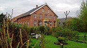
One of the notable buildings in Manslagt is the late Gothic Manslagter Church , which was built around 1400. Its pulpit was made in Amsterdam in 1714. The baptismal font is made of Bentheim sandstone and is most likely older than the pulpit. The oldest inscriptions on the tombstones in the church refer to the years 1599 and 1637. Remains of the Beninga castle can be found on Mittelweg in Manslagt. However, only the gable of the main house can be seen.
At Dbodstraat 7 there is a stone house that was transformed into a Gulfhof around 1840 . It was extensively renovated in 1997 and features, among other things, a richly decorated gable. The stable building is used for village events. At Grode Katjeweg there is a typical country house with a barn, which was built in 1769 (see picture). After a thorough renovation, which was carried out in 2006 with partly historical materials, it is now used as a holiday home . "Probably the oldest residential building" of the Krummhörn is located at Manslagter Langen Strasse 3 . It is well over six hundred years old. The "lying roof structure has been preserved in the original". The masonry consists partly of monastery format stones . A walled-up Gothic window can also be seen. The so-called Buschhaus is located on the road from Manslagt to Groothusen . It dates from 1570 and was renovated in 1997.
A bronze model of the Warfendorf is set up on the square in front of the church. The illustration shows Manslagt in the period around 1950. It was included as a so-called tactile object in the database of tourist offers for blind and visually impaired people .

Manslagter Church

The gable of Manslagt Castle still preserved
Manslagter Gulfhof Between the courtyards

Historic houses (right: a typical rural house from 1769)
_IMG_6634.jpg)


Economy and Infrastructure
traffic
The district road 233 (Aurich district) leads through Manslagt, which leads exclusively through Krummhörner municipality and connects the fishing village Greetsiel with Groothusen. The next motorway junction ( A 31 ) is 13 kilometers away and is in Emden .
The Manslagter bus stop, which is on the western edge of the core village, is approached several times a day by a bus on line 421 of the Ems-Jade transport association . The line 421 connects Manslagt north across Pilsum with Greetsiel. There is a connection to the north (East Friesland) . In a southerly direction it leads via Groothusen and Woquard (you can change to line 422 in the direction of Emden Hauptbahnhof ) to the central bus station in Pewsum. The nearest train station is in Emden. Manslagt had a stop at the Emden – Pewsum – Greetsiel circuit , which ceased operations in May 1963 and was then dismantled.
The Manslagter Tief has a length of around 2.5 kilometers. Through the low, Manslagt has a connection to the East Frisian sewer network. The low begins east of the town center and flows between Manslagt and Visquard to the New Greetsieler Sieltief , which represents the connection with Greetsiel on the one hand and ultimately with Emden on the other. It is part of the close-knit network of the Krummhörner waterway system and has a small pier east of the village center, from which water walks to Greetsiel , Hinte and Emden are possible. However, only non-motorized driving on the deep is permitted. Its average width is six and its depth 0.8 meters.
The Krummhörn-Tour cycle path leads through Manslagt, which connects all 19 villages of the Krummhörn and is 63 kilometers long.
Personalities
- Menso Poppius , Reformed preacher
- Herman Mercator († 1650), Reformed preacher
- Uko Johannis († 1691), reformed preacher
- Aitzo Hotetza Nieland († 1664), Reformed preacher
- Tjarko Meyer Cramer (born June 1, 1780 in Manslagt, † April 26, 1812 in Rome ), history painter
- Karl Immer (born May 1, 1888 in Manslagt; † June 6, 1944 in Bad Meinberg ), Reformed theologian, a. a. Pastor in Wuppertal- Barmen , member of the Confessing Church and co-author of the Barmen Declaration . Always buried in the cemetery in Barmen-Gemarke.
- Peter Smidt (1894–1957), poet and writer
- Klaus Immer (born March 9, 1924), politician (SPD)
- Alfred Boatswain former local representative (SPD)
- Roelf Odens (born May 17, 1969), local representative (CDU)
literature
- Karl Leiner: Panorama North District . Norden 1972, p. 265 ff.
- Daniel Schmeda: The manslagter . 2nd edition, Krummhörn-Pewsum 1994
Web links
- Touristik-GmbH Krummhörn-Greetsiel: Manslagt , accessed on May 25, 2013
Individual evidence
- ↑ Gerhard D. Ohling: Kulturgeschichte des Krummhörn , in: The eight and their seven sluices ; (Ed. Gerhard Steffens on behalf of the I. Drainage Association Emden, based in Pewsum), Pewsum 1987, Volume I, p. 31
- ↑ Gerhard D. Ohling: Kulturgeschichte des Krummhörn , in: The eight and their seven sluices ; (Ed. Gerhard Steffens on behalf of the I. Drainage Association Emden, based in Pewsum), Pewsum 1987, Volume I, p. 35
- ↑ The information in this section refers to Eberhard Rack: Landeskunde Ostfriesland , Norden 1974, p. 81
- ↑ Daniel Schmeda: The Manslagter , Pewsum 1995, p 19
- ↑ Wasser- und Schifffahrtsamt Emden: Expert opinion on the deepening of the Außenems (December 19, 2012), PDF document, p. 22 ( Memento of the original from December 21, 2016 in the Internet Archive ) Info: The archive link was inserted automatically and has not yet been checked . Please check the original and archive link according to the instructions and then remove this notice. , accessed on May 11, 2013.
- ↑ Wadden Sea National Park: Map , accessed on January 5, 2016.
- ↑ Compare the street names Schlachte in Jever , Emden , Bremen and elsewhere; Gerhard D. Ohling: Kulturgeschichte der Krummhörn des Krummhörn , in: The eight and their seven sluices (Ed. Gerhard Steffens on behalf of the I. Drainage Association Emden, Headquarters Pewsum), Pewsum 1987, Volume I, p. 35
- ^ Arend Remmers: From Aaltukerei to Zwischenmooren. The settlement names between Dollart and Jade. Schuster Verlag, Leer 2004
- ↑ Ine Ubben Ross: Ernestinchen. Original and historical from Krummhörn , Emden o. J., p. 51ff
- ↑ a b c d e East Frisian landscape: Manslagt, municipality of Krummhörn, district of Aurich (PDF; 876 kB), accessed on May 7, 2013.
- ↑ Fridrich Arends: Earth Description of the Principality of Ostfriesland and Harlingerland , Emden 1824, p. 349
- ^ Forum turntable: Long history: Kreisbahn Emden-Pewsum-Greetsiel (m32B) , accessed on May 8, 2013.
- ↑ Hans Bernhard Eden: The Resident Services of East Frisia from 1919 to 1921 . In: Emder Yearbook for Historical Regional Studies Ostfriesland , Vol. 65 (1985), pp. 81-134, here pp. 94, 98, 105, 114
- ↑ District Fire Brigade Association Aurich e. V .: Manslagt-Pilsum fire brigade . Retrieved May 8, 2013.
- ^ Harm Wiemann / Johannes Engelmann: Old streets and ways in East Frisia . Self-published, Pewsum 1974, p. 169 (Ostfriesland in the protection of the dike; 8).
- ^ Gunther Hummerich: The peat shipping of the Fehntjer in Emden and the Krummhörn in the 19th and 20th centuries . In: Emder Yearbook for Historical Regional Studies in Ostfriesland , Volume 88/89 (2008/2009), pp. 142–173, here p. 163
- ↑ Daniel Schmeda: The Manslagter , Pewsum 1995, p 27 f.
- ↑ Daniel Schmeda: The Manslagter , Pewsum 1995, p 21
- ^ Hans Forster / Günther Schwickert: North - a district town under the swastika (Ed. Norder Jungsozialisten and SPD-Ortsverein), Norden 1988, p. 53; 63
- ↑ For comparison: the memorial records 27 dead for the First World War . See also Upstalsboom Society: Friedhöfe. Manslagt , accessed May 25, 2013.
- ^ Johann Haddinga : 50 years ago: Hurricane flood in East Frisia. In: Ostfriesischer Kurier from January 28, 2012 (PDF; 11.2 MB), accessed on February 15, 2019.
- ↑ Menno Smid : East Frisian Church History. Self-published, Pewsum 1974, p. 43 (Ostfriesland in the protection of the dike, vol. 6).
- ↑ Gerhard D. Ohling: Kulturgeschichte des Krummhörn , in: The eight and their seven sluices . (Ed. Gerhard Steffens on behalf of the I. Drainage Association Emden, based in Pewsum), Pewsum 1987, Volume I, p. 233
- ↑ Holger Balder (ed. On behalf of the church council of the evangelical-reformed parish of Rysum): The Gothic organ in the Rysum church. Festschrift for the 555th anniversary of the Gothic organ Rysum 2012 , Rysum 2012, p. 66 ( online , accessed on February 11, 2020).
- ^ Walter Holweg: The history of older Pietism in the Reformed communities of East Frisia. From its beginnings to the great awakening movement (around 1650–1750) , Aurich / Leer 1978, p. 37; 162ff; 177; 210
- ↑ Lutheran Confessional Congregation: Pastor Remmer Janssen. A letter of Christ , accessed May 25, 2013; it is the online edition of the book Günther Maske and Johannes Mindermann (ed.): Pastor Remmer Janssen. A letter of Christ , Aurich 1973 (new edition).
- ↑ The data and facts in the following section are - unless otherwise noted - taken from the following article: Rüdiger Schoel: A historical view of schools in the north district using the example of the Krummhörn , in: Karl Leiner: Panorama north district. Pictures, coats of arms, people, notes , Norden 1972, pp. 537–557
- ↑ Menno Smid: East Frisian Church History . Self-published, Pewsum 1974, p. 302
- ^ FG Leonhardi (Ed.): Earth Description of the Prussian Monarchy , Volume IV / 2, pp. 1183ff ( online , accessed on May 19, 2013).
- ↑ Derived from the French Bailliage = Vogtei.
- ↑ This may be a typographical error. Is probably meant Gretmer .
- ↑ See Jacob de Gelder: Aardrijkskundige Beschrijving van het Koningrijk Holland , Amsterdam 1809, pp. 529–550 (pp. 534f) - online , accessed on May 21, 2013.
- ^ Federal Statistical Office (ed.): Historical municipality directory for the Federal Republic of Germany. Name, border and key number changes in municipalities, counties and administrative districts from May 27, 1970 to December 31, 1982 . W. Kohlhammer, Stuttgart / Mainz 1983, ISBN 3-17-003263-1 , p. 263 f .
- ↑ The figures for the years between 1821 and 1970 are taken from the local article Manslagt, municipality Krummhörn, district Aurich ( Ostfriesische Landschaft (PDF; 876 kB). Accessed on May 7, 2013); the population for 1983 is from Jürgen Hoogstraat: Krummhörn-Führer , Norden 1984, p. 19; the source for the 2013 population can be found here: Travel World Atlas: Manslagt , accessed on May 7, 2013.
- ↑ Catholic Church Emden: Divine Services , accessed on May 9, 2013.
- ↑ Figures based on the East Frisian Landscape: Manslagt, Krummhörn municipality, Aurich district (PDF; 876 kB), accessed on May 7, 2013.
- ^ Karl Leiner: Panorama district north. Pictures, coats of arms, people, notes , Norden 1972, p. 265
- ↑ Johannes C. Stracke: The portrait graves of East Frisia from the 15th to 17th centuries , Aurich 1976, p. 98
- ^ Karl Leiner: Panorama district north. Pictures, coats of arms, people, notes , Norden 1972, p. 267 ff.
- ↑ ANNO - Society for the Preservation of East Frisian Cultural and Architectural Monuments e. V .: Flyer On the route of building culture. With Anno unnerwegens (section Manslagt ) ( Memento of the original from June 26, 2013 in the Internet Archive ) Info: The archive link was automatically inserted and not yet checked. Please check the original and archive link according to the instructions and then remove this notice. (PDF; 8.3 MB), accessed on May 10, 2013.
- ↑ Databus: bronze model of the village of Manslagt , accessed on May 8, 2013.
- ↑ Nordwestreisemaganzin: Manslagter Tief , accessed on May 7, 2013.
- ↑ Bikemap: Route: Krummhörn-Rundtour , accessed on May 7, 2013.
