Niederbipp
| Niederbipp | |
|---|---|
| State : |
|
| Canton : |
|
| Administrative district : | Oberaargau |
| BFS no. : | 0981 |
| Postal code : | 4704 Niederbipp 4704 Wolfisberg |
| Coordinates : | 619 466 / 235055 |
| Height : | 468 m above sea level M. |
| Height range : | 433-1232 m above sea level M. |
| Area : | 19.77 km² |
| Residents: | 4899 (December 31, 2018) |
| Population density : | 248 inhabitants per km² |
| Mayor : | Sibylle Schönmann ( SVP ) |
| Website: | www.niederbipp.ch |
|
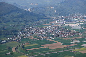
Aerial view of Niederbipp, taken from a balloon |
|
| Location of the municipality | |
Niederbipp is a municipality in the Oberaargau administrative district in the canton of Bern in Switzerland .
geography

Niederbipp lies at 468 m above sea level. M. , about halfway between Olten and Solothurn , 14 km northeast of Solothurn ( linear distance ). The village extends on the flat alluvial cone formed by the Bipperbach at the southern foot of the Jura and in the plain of the Bipperamt in Oberaargau .
The area of the 17.2 km² large municipal area covers a section of the northern Bernese Mittelland . The main part of the area is taken up by the gravel plain of the Bipperamt (on average at 460 m above sea level ), which has a width of around 3 to 4 kilometers. It is drained by the Bipperbach, which is straightened and canalized in the plain, to the northeast to the Dünnern . In the south, this plain is separated from the Aare valley by a ground moraine wall , which was formed by the Ice Age Rhone glacier . The wall with a slight relief is made up of the extensive wooded area of the Längwald and reaches at its highest point 507 m above sea level. M. In the far east, the parish ban extends down to the edge of the Aareniederung.
The north-western part of the municipality includes the largely wooded southern slope of the Lebernberg , the foremost anticline of the Jura . The Bipperbach rises here and flows down into the plain through a steep valley, which only got its shape after a landslide at the end of the crack ice age . The border mostly runs on the ridge of the Lebernberg; on the eastern flank of the Höllchöpfli is at 1150 m above sea level. M. reached the highest point of Niederbipp. In 1997, 12% of the municipal area was accounted for by settlements, 38% for forests and woodlands and 50% for agriculture.
Niederbipp includes the wooden houses ( 462 m above sea level ) and Scharnageln ( 461 m above sea level ) settlements on the Bipper level, Dürrmühle ( 471 m above sea level ) on the northern edge of the village, Leen ( 500 m above sea level). ) on the southern slope of the Lebernberg, Antere ( 514 m above sea level ) in the valley of the Bipperbach and Walden ( 681 m above sea level ) on a ledge on the slope of the Lebernberg and various individual farms. Neighboring communities of Niederbipp are Schwarzhäusern , Bannwil , Oberbipp and Rumisberg in the canton of Bern and Matzendorf , Laupersdorf , Balsthal , Oensingen and Kestenholz in the canton of Solothurn .
population
With 4899 inhabitants (as of December 31, 2018) Niederbipp is one of the medium-sized municipalities in the canton of Bern. 89.0% of the residents speak German, 3.1% speak Serbo-Croatian and 1.8% speak Albanian (as of 2000). The population of Niederbipp was 2337 inhabitants in 1850 (at that time the largest town in the district of Wangen), in 1900 it was 2245 inhabitants. In the course of the 20th century, the population rose continuously to 3,050 people by 1950. After a period of stagnation lasting around 30 years, a significant population increase has been recorded again since 1980 (3165 inhabitants).
economy
Until the middle of the 20th century, Niederbipp was predominantly an agricultural village. In addition, thanks to the good traffic situation, various industrial and commercial enterprises developed relatively early.
Today Niederbipp offers around 1,800 jobs. With 12% of the gainfully employed who are still employed in the primary sector, agriculture (mainly arable farming , fruit growing , dairy farming and forestry ) still has a certain role in the employment structure of the population. About 37% of the workforce is employed in the industrial sector, while the service sector accounts for 51% of the workforce (as of 2001).
Since the early 1970s, larger industrial and commercial zones have emerged near the motorway junction and on the north-eastern edge of the village. The most important companies of Niederbipp include Kimberly-Clark GmbH, which is active in the paper industry, as well as IFF AG, a gravel mining and processing company (extensive gravel pits are exploited on the edge of the Längwald), and Galexis AG, a pharmaceutical distribution company who has been based in Niederbipp since 2008. There are also numerous small and medium-sized companies in the construction and transport industry, information technology, mechanical engineering, wood processing, electrical and lamp industry, metal construction, precision engineering workshops, trading companies and distribution centers.
Niederbipp is also the location of a regional retirement and nursing home. In the Räberhus, a multi-purpose building, cultural and social events take place. In the last few decades the village has developed into a residential community thanks to its attractive location. Many employed people are therefore also commuters who work mainly in the other larger towns along the southern foot of the Jura between Olten and Solothurn.
politics
The voting shares of the parties on the occasion of the National Council elections in 2019 were: SVP 42.2%, FDP 15.1%, SP 12.6%, GPS 7.3%, glp 7.5%, BDP 6.2%, CVP 2.0 %, EVP 1.7%.
traffic
The community is very well developed in terms of transport. It is located on the main road 5 from Solothurn to Olten , from which a connection to Langenthal branches off. The nearest connection to the A1 motorway (Bern-Zurich), which crosses the municipality, is around 1.5 km from the town center.
On December 4, 1876, the Gäubahn from Olten to Solothurn was put into operation with a train station in Niederbipp. In addition, on October 26, 1907, there was the meter-gauge line of the Langenthal-Jura-Bahn and on January 9, 1918 the opening of the meter-gauge line of the Solothurn-Niederbipp-Bahn . The Solothurn – Niederbipp – Langenthal route is now operated on a mobile basis by the Aare Seeland .
history
The municipality of Niederbipp was already settled during the time of the Celts and the Romans . The Celtic name of the place was probably Betwa . Niederbipp was first mentioned in a document in 866 under the name Pipinensis ; of 968 Pippa has been handed down. However, a clear assignment has only been possible since the 13th century: inferiore Bippe (1263), Bippo (1268), Nider-Bippe (1302), Nidern Byppe (1406) and Nider Bip (1464). Bipp goes back to the Germanic personal name Bippo or Pippin and therefore means property of Bippo / Pippin .
Since the Middle Ages Niederbipp has been under the Landgraviate of Buchsgau , which was administered by the Counts of Frohburg . It belonged to the rule of Bipp and since the beginning of the 14th century to the office of Erlinsburg, which came to the Counts of Neuchâtel-Nidau in 1332. Furthermore Niederbipp shared the fate of the Bipp rule, which experienced numerous changes of ownership. As part of this rule, the village came under the joint administration of Bern and Solothurn in 1413. After the division of Buchsgau, Niederbipp came under the sole sovereignty of Bern in 1463 and was assigned to the Bipp bailiff.
After the collapse of the Ancien Régime (1798) Niederbipp belonged to the district of Wangen during the Helvetic Republic and from 1803 to the Oberamt Wangen, which received the status of an official district with the new cantonal constitution of 1831.
Attractions
The parish church, which originally dates back to a medieval church and stands on the site of the Roman settlement, was given its current appearance through renovations in 1669 and 1712. The late Gothic rectory was built from 1577 to 1579. The oldest farmhouse in Oberaargau is on Kirchgasse, built in 1475 and modified in 1586. Various characteristic farmhouses (high-rise buildings) from the 17th to 19th centuries have been preserved in the old town center.
Remains of the Vorderen (also Oberen) Erlinsburg, which was built in the 13th century, are visible on the rock of the Leenberg on the southern slope of the Jura above the village.
Personalities
- Helene Roth (1887–1966), painter, died here
- Gerhard Meier (1917–2008), writer and literary prize winner. In his works, his place of residence Niederbipp has the name Amrain . As a special honor for his literary work, Niederbipp named the street in which Gerhard Meier lived after him.
- Rahel Frey (* 1986), Swiss car racing driver
Web links
- Official website of the Niederbipp community
- Anne-Marie Dubler : Niederbipp. In: Historical Lexicon of Switzerland .
Individual evidence
- ↑ Permanent resident population from STAT-TAB of the BfS , municipalities see also regional portraits 2020 on bfs.admin.ch, accessed on May 29, 2020
- ^ Election results for the Niederbipp community. State Chancellery of the Canton of Bern, October 20, 2019, accessed on August 20, 2020 .


