Prali
| Prali | ||
|---|---|---|

|
|
|
| Country | Italy | |
| region | Piedmont | |
| Metropolitan city | Turin (TO) | |
| Coordinates | 44 ° 53 ' N , 7 ° 3' E | |
| height | 1454 m slm | |
| surface | 72 km² | |
| Residents | 248 (Dec. 31, 2019) | |
| Population density | 3 inhabitants / km² | |
| Post Code | 10060 | |
| prefix | 0121 | |
| ISTAT number | 001202 | |
| Popular name | Pralini | |
| Website | Prali | |

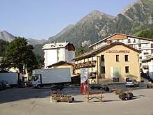
Prali (until 1937 Praly ; Occitan Praal ) is a high alpine municipality with 248 inhabitants (as of December 31, 2019) in the Valle Germanasca in the Italian metropolitan city of Turin (TO), Piedmont region . It is located in the Cottian Alps near the border with France.
The ecumenical meeting center Agape , founded in 1946 by the Waldensian pastor Tullio Vinay and planned by the architect Leonardo Ricci, is located near Prali . The construction of the Diakoniezentrum Monte degli Ulivi in Riesi , Sicily, goes back to her initiative .
geography
Valle Germanasca is a side valley of Val Chisone (French: Val Cluson) and one of the three Waldensian valleys , where the Calvinist lay movement of the Waldensians, with its center in Torre Pellice , had its retreat.
The municipality of Prali covers an area of 72 km².
The neighboring communities are:
- in Germanasca (down the valley) Salza di Pinerolo and Perrero
- in the main valley (north of the mountain range) Pragelato (French Pragela) and Sauze di Cesana
- in the Valle Pellice (southern parallel valley ) Angrogna as well as Bobbio Pellice and Villar Pellice
- across the French border Abriès-Ristolas with Abriès in the Hautes-Alpes department .
Parish partnership
- Abriès , France
Individual evidence
- ↑ Statistiche demografiche ISTAT. Monthly population statistics of the Istituto Nazionale di Statistica , as of December 31 of 2019.
- ↑ https://agapecentroecumenico.org


