
Teltower Dörferweg
| Teltower Dörferweg | |
|---|---|
 View from the Rudow-Altglienicke Landscape Park towards Rudow |
|
| Data | |
| length | 45 kilometers |
| location | Berlin (green main path) |
| Supervised by |
FOOT e. V. BUND-Berlin Citizens' Project "Network" Berliner Wanderverband Stadtentwicklung |
| Markers |
 Blue field, white "15" |
| Starting point |
Spreeufer ( Spreeweg ) 52 ° 27 ′ 11.1 ″ N , 13 ° 33 ′ 13 ″ E |
| Target point |
Krumme Lanke (east bank / Wannseeweg ) 52 ° 27 ′ 17 ″ N , 13 ° 14 ′ 25.7 ″ E |
| Type | trail |
| Height difference | low |
| Level of difficulty | inner city |
| season | all year round |
| Viewpoints |
Rudower Höhe ( 70 m above sea level ) Village view ( 86 m above sea level ) |
| particularities | The path connects historic Teltow villages in the south of Berlin |
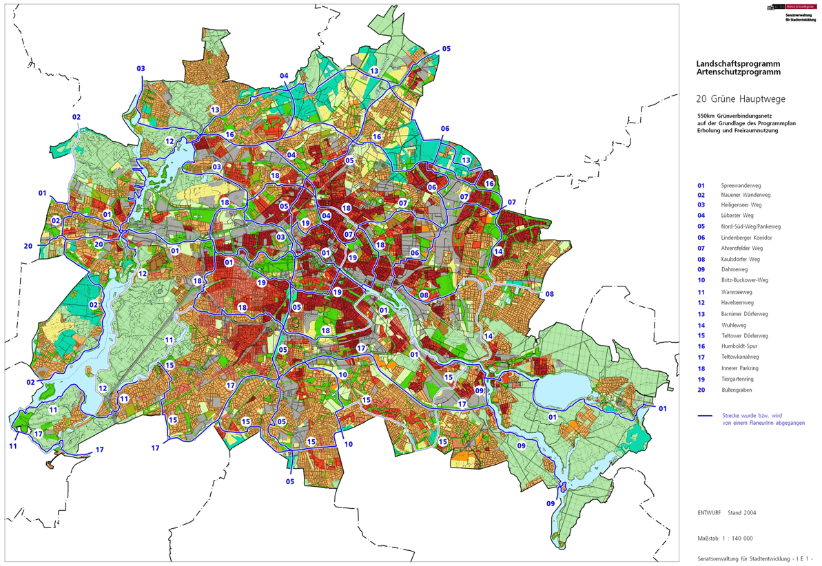
The Teltower Dörferweg is number 15 of the 20 main routes green . This is a compilation of 20 hiking trails through the Berlin urban area with a total length of around 550 kilometers. The aim is to link “residential areas with the diverse recreational opportunities in parks and local recreation areas in Berlin and Brandenburg ” (Senate Department for Urban Development and the Environment). The pedestrian should have the opportunity to “experience the city intensely as a combination of culture, history and ecology”. The Dörferweg connects districts in the south of Berlin that have their origins in the villages on the Teltow.
course
The Teltower Dörferweg is 45 kilometers on the Teltower plateau and runs from village to village. Around 1900 it would have run between the Grunewaldseenkette and the Köpenicker Spree over rural regions with fields, meadows and small villages. Today the southern area of Berlin is built on and the historic village structures are hidden, as can be seen from the large arable land around Gropiusstadt, which was built from 1962 to 1975 . The Teltower Dörferweg opens up the residential areas of Zehlendorf , Lichterfelde , Marienfelde , Lichtenrade , Buckow , Rudow and Adlershof between west and east . The view from east to west is then provided by the viewing platform of the Rudower Höhe in the Rudow-Altglienicke Landscape Park , which is more recent and emerging is the landscape park north of Adlershof , which will open up the untouched meadows of the former Johannisthal airfield .
The main route is described below from east (Oberspree) through south to west (Zehlendorf).
Niederschöneweide
The Teltower Dörferweg has the eastern starting point ( map ) with connection to the Spreeweg (currently not continuously accessible on the south bank of the Spree) in Niederschöneweide at the level of the KGA 'Am Freibad'. A connection to the transport network is possible from the nearby Oberspree S-Bahn station . From the Spree west of the KGA Am Freibad Oberspree you go to Bruno-Bürgel-Weg and on this 150 meters to the left to Ostritzer Straße . The S-Bahn line to Spindlersfeld is crossed at the same level and then a footpath leads to the right into a wood and on this 360 meters it goes to the left through the KGA 'Waldland 1911'. The Oberspreestrasse follows the residential buildings , before leaving the district.
Adlershof and Johannisthal

When you reach Oberspreestraße , you change to the Adlershof district , bypassing the old village center to the east. The main path 15 continues straight through the Köllnische Heide , around the sports field in the Birkenweg to the left to a newly built private home complex ( Zur Holzoper ), Genossenschaftsstraße , right into Vogelbeerstraße and left into Husstraße with two-storey terraced houses. The 50-meter-long Eigenheimgasse to the left leads to Anna-Seghers-Straße , which is used to get to Dörpfeldstraße with the tram. From Dörpfeldstraße over Adlergestell , you go through the railway bridge at Adlershof S-Bahn station to Rudower Chaussee . After a short stretch, the Teltower Dörferweg leads into Wagner-Regeny-Strasse (to the right) and further into Pfarrer-Goosmann-Strasse , where the local employment agency and facilities for the Treptow-Köpenick district are located. On the Groß-Berliner-Damm to the right, the built-up area is left behind the Hermann-Dorner-Allee (left) and the Igo-Etrich-Straße and thus the district.
From the corner of Groß-Berliner-Damm and Hermann-Dorner-Allee there is a change to Johannisthal . ( Map ) In Johannisthal, the green main route 15 now follows westwards on the former Johannisthal airfield to the southwest, alternating on the border between the LSG and the NSG . The NSG Landschaftspark Johannisthal is located on the central part of the former airfield site, which retained its natural characteristics through its use as a military training area for the Adlershof guard regiment until 1990 ; overall, this area is marked as the Johannisthal / Adlershof Landscape Park and is increasingly being expanded. The further path leads within the open area of the landscape park to the south to the level of Johann-Hittorf-Straße (Oktogon). To the left to Hermann-Dorner-Allee and on this right it goes on its western edge (on the Adlershof area) over the Eisenhutweg , which continues beyond the street crossing as Rudower Chaussee in Adlershof. The Dörferweg continues straight ahead to the south on Hermann-Dorner-Allee to Ernst-Ruska-Ufer (access to A 113 ), through the motorway bridge the pedestrian / cycle path bridge next to the motorway is reached via a bridge ramp , with Johannisthaler terrain again for a short time is entered.
Below this bridge path, the Teltow Canal Path crosses on the northern bank of the canal. Johannisthal is left over the north bank of the Teltow Canal, whereby the width of the motorway and the Ernst-Ruska-Ufer, which serves as a feeder, still belong to the district. In addition, the Wall Trail alternates between the Teltow Canal and the Teltower Villages Trail in this area .
Rudow and Altglienicke

The Teltow Canal belongs to Rudow , so it also crosses the Treptow-Köpenick / Neukölln district border. Previously and before the construction of the motorway, the border between East and West Berlin was here in the wall . However, at the end of the bridge, after 100 meters, the Alt-Glienicke district (again Treptow-Köpenick district ) follows . The Teltower Dörferweg runs together with the Berlin Wall Trail on the west side of the A 113 on a well-developed asphalt stretch of path, between bushes and meadows, which is also used as a skater route. The motorway runs along the district border, so this path changes in parts between the districts of Rudow and Alt-Glienicke, but is mainly on Altglienicker Flur. The motorway is partly in the tunnel and is otherwise soundproofed and invisibly separated from the main road by a soundproof wall.
The main path (in Altglienicke) initially crosses Rudower Straße, which is divided by a pedestrian island and, next to the Kiessee, reaches the Rudow-Altglienicke Landscape Park , with the motorway leading into the "Rudower Höhe tunnel". The settlement Rudower Höhe ( An der Rudower Höhe , Niederschlemaer Weg ) lies behind a forest strip (formerly border strip) in Rudow. To the right, 150 meters from the main path, lies the Rudower Höhe landscape area on Rudower Terrain , a hill 70.4 m above sea level. NN followed by the KGA 'Rudower Höhe' and the weekend settlement 'An der Rudower Höhe', on the left in Altglienicke a residential area around Braunellenplatz , followed by the Grüneck settlement ( Kasperstrasse ).
On the Dankmarsteig , which is located in both districts (Rudow: Mozartring ), the district border changes for 100 meters via Hauptweg 15 and after 50 meters (Altglienicke) again for 20 meters to Rudow. The area of the landscape park with the municipal cemetery is now mainly in Altglienicke on the left. In addition, the motorway tunnel ends here and the village path, which is close to the motorway because of the following Rudow settlement, runs 400 meters in Rudow. Halfway there is a pedestrian bridge connecting the two districts across the autobahn, which is deepened in a trough between noise barriers; the 300-meter-long Alt-Glienicke tunnel begins at Lutz-Schmidt-Strasse . Since the local part (district) border deviates to the west here, the main and wall paths lead through Altglienicke. The area (mainly grassland) is also part of the landscape park. While the motorway leads south to the east, the village path goes off to the west. After 600 meters there is another settlement in the west ( Deuschtaler Straße , Am Klarpfuhl ) and an orchard in the east in Altglienicke. The Altglienicke district is left here.
Rudow

The district of Rudow is reached 150 meters before the B 179 ( Waltersdorfer Chaussee ), the city limits are also reached here. This is indicated by the transition ( map ) from Berlin to Schönefeld ( Brandenburg ). Here was formerly a border crossing point , allowing access from West Berlin to - in the GDR - located Schoenefeld Airport offered.
At the edge of the Rudower Südpark , you continue on the city limits between Berlin and Brandenburg to Rudower Chaussee . Behind the park area is the Rudow women's quarter with four-storey residential buildings on Hildrud-Dudek-Weg . This is followed by Schönefelder Straße (continuing as Rudower Chaussee in Schönefeld in Brandenburg). Here the green main path turns right (northwards) into this street, while the Wall Path continues straight on at the city limits. Between the settlement on Schönefelder Straße and this street, the main path goes on the street 184 to the left and then to the right on the plant paths of the 70 meter wide allotment garden strip (KGA 'Weimars Ruh', KGA 'Steingrube') around the street 183 (to the corner Straße 148) to bypass a plot of land on Schönefelder Straße for 20 meters. The main path continues through the meadow area at the Meskengraben (Meskenbecken) and around the Lolopfuhl natural monument to the western edge of the meadow area and through a forest parallel to the properties on road 179 . With the crossing of the Waßmannsdorfer Chaussee (on both sides the KGA 'Waßmannsdorfer Fliederheim') it goes between the two natural monuments Großer (right hand) and Kleiner Rohrpfuhl and into the colony 'Ewige Heimat' on the Rhodeländerweg (it is part of the settlement with Street names according to chicken breeds) to Groß-Ziethener Chaussee . Before that, the KGA 'Ewige Heimat' lies on both sides of the road and, to the west, the 'Siedlung am Bahnhof Rudow'. Over the Ziethener Chaussee a few steps to the right through a park with the path on a footbridge over the Rudower Fließ , from which it continues to the northwest, on the Bildhauerweg and through the KGA 'Zittauer Straße' on the further green corridor to the Zwickauer Dam . Beyond that, after 280 meters through the 40-meter-wide green area, the tracks of the industrial railway , which previously supplied the Rudow power station , are reached. With the Wutzkyallee to the right, the district is left at the railroad track.
Gropiusstadt

The tracks of the industrial railway mark the change of district ( map ) from Rudow to Gropiusstadt , which is reached from the Teltower Dörferweg on Wutzkyallee . Gropiusstadt emerged in the 1960s and 1970s on fields and arable land in the villages of Buckow and Rudow. The further path to the left north of the railroad tracks leads into the Rudower Wäldchen , a landscape protection area on the outskirts of the city with the former wall near, which continues in Brandenburg to the south as "Park am Vogelwäldchen". In the Rudow grove, it goes north over the Sollmannweg to Wildmeisterdamm , the (historical) connecting path between Buckow and Rudow. The Rudow grove ends here in front of the convexly curved Gropiushaus. The Wildmeisterdamm walked to the left first crosses Lipschitzallee (180 meters to the Lipschitzallee underground station ), further over Bat-Yam-Platz it goes the next 1350 meters through built-up area with surrounding green along the southern edge of Gropiusstadt, including in particular the green corridor above the underground line U7 . The last part of the straight stretch of the route crosses the Wermuthweg and then lies parallel to it up to the Kölner Damm . On the western sidewalk of the Kölner Damm, the main path is on the border between Gropiusstadt and Buckow.
Near the subway station of the same name , the 40 meter wide Johannisthaler Chaussee is crossed (traffic light regulated). When changing to the Tischlerzeile for 70 meters to Severingstraße ( map ), the right sidewalk used is on the district boundary of Gropiusstadt / Britz and there is a change of districts within the Neukölln district .
Britz

Britz is also a former Teltowdorf, but due to its closer location to Berlin, it was more developed than the neighboring towns. When you reach Britz via Johannisthaler Chaussee, an ideal tour of the Teltower Dörferweg is provided to the left to the railway track of the Neukölln-Mittenwalder Railway located here and then to the right to the Hochspannungsweg . The recommended replacement for the green main path [obsolete] leads on the Tischlerzeile via the Malersteig and Bauführerweg to the high-voltage path , which must be taken to the left in front of the Wetzlar school. This green path through the residential areas of the Neuland settlement was retained. The route of a high-voltage line from the Zschornewitz power plant to the former location of an aluminum plant (today: Klingenberg power plant ) has been located here since 1918 . After crossing the tracks of the Neukölln-Mittenwalder Bahn, follow the carpenter , roofer , stone girders and mason path across to Buckower Damm . The high-voltage path follows a piece of the Britz / Buckow border, with the entrance to the Britzer Garten and the Neukölln park cemetery on the opposite side . This is followed by the 'Heimaterde' colony and, across the Breiter Weg , the 'Kurt Pöthig' colony in Britz with the high-voltage route as a border route to Buckow. 150 meters after the Breiter Weg, the Teltower Dörferweg leads to the left into the Buckow district.
Buckow

When you change to Buckow ( map ), the Teltower Dörferweg and the Britz-Buckower Weg (Hauptweg 10) coming from Breiter Weg lead to the southeast between the residential buildings on the eastern Bienwald ring and the western Bernsteinring to the new housing estate In den Garten and Marienfelder Chaussee ( the western extension of Alt-Buckow ). This tour of the main path in the north bypasses the old village center. The 40-meter-wide, two-lane Marienfelder Chaussee with a median and heavy car traffic in the south of Berlin is offset to the left (80 meters) to overcome the Delmer Steig , a green footpath behind which the turning hammer follows the street. The two main routes 10 and 15 jointly use this route (via Salmbacher Strasse and Tribacher Strasse ) to Warmensteinacher Strasse on which it goes a little to the right to a narrow green passage behind their property to the south. This park path leads between residential buildings next to Ernst-Arndt -Weg and Pfarrer-Wenke-Weg to Gerlinger Straße . The city limits are reached via the latter between the Töpchiner Weg landscape park (an area of arable land) and the KGA 'Buckower Feldmark'. The Britz-Buckower Weg ends here. The Teltower Dörferweg bends westwards (to the right) to Töpchiner Weg , this is the continuation of Gerlinger Straße around the corner of the city limits and is still reached from the Dörferweg in Buckow, called Grenzweg. The Wall Trail at the city limits leads 90 meters through the forest on the former wall strip, but remains on the edge of the Brandenburg arable land around Großziethen .
Lichtenrade
The Töpchiner Weg ( map ) leads the main path on the (this side, i.e. eastern) sidewalk over the Neukölln / Tempelhof-Schöneberg district border into the Lichtenrade district . Passing the Selterstraße , Krontal- , Schwalbach- , Kamberg- , Kloster-Zinna-Straße going off to the left , the path in front of Straße 9 leads to the former railway line over the street and through a meadow / green area to Alt-Lichtenrade and this street to the left used to a place that these, the Töpchiner Weg, Homburgstrasse and Fehlingstrasse form. A main road ( Lichtenrader Damm ) is crossed from Fehlingstrasse to Grimmstrasse . This is followed to the western end ( Neue Heimat , Luther- , Schillerstraße , Halkerzeile , Krusaer Straße , Rotenkruger Weg crossing) on Geibelstraße and the latter is crossed to a parking area behind the property on Werfelstraße . Furthermore, Simpsonstrasse is crossed and the path through the green ends at Neanderstrasse . At this point 150 meters from the Schichauweg S-Bahn station , the Dörferweg leads north on Neanderstraße away from Barnetstraße . On the system route through the railway farm on the former route of the outer freight ring (which belongs to Fontanestrasse), there is a railway underpass through the S-Bahn line to Mahlow (line S2).
Marienfelde
To the east of the Dresden Railway (S-Bahn line S2) is the change of district ( map ) from Lichtenrade to Marienfelde (both in the Tempelhof-Schöneberg district ). The Miethepfad is reached through the railway underpass at its northern turning loop, from there to the right the path leads back to the route of the former freight outer ring . This path is developed as a paved footpath and bike path (tansy path), it is used to the west (left hand). The Motzener Straße is crossed, before and after the paved path leads to the Königsgraben through an industrial area. However, trees and bushes were embedded in the expansion of the Güteraußenring-Weg, which cover the company fences and the commercial buildings. At the Königsgraben a footpath with the north-south path (main path 05) is led across the route as Adolf-Kiepert-Steg .

Further to the west there are now green main routes 05 and 15 together on the route of the outer freight ring on the southern edge of the Marienfelde amusement park . At its southwest corner in front of the KGA 'Am Freizeitpark' and north of a facility of the Federal Environment Agency and the KGA 'Birkholz', the two main paths on the western edge of the park, a former garbage dump , go north (i.e. to the right) to the elevation (76 meters) and further around the commercial buildings on the left-hand side of the path (later to the left) you go to the KGA 'Am Diedersdorfer Weg' and turn right again to the Schlehenberg (height 58.5 meters). Before this elevation, the path leads to the left (westwards) through the KGA 'Amstelveen' to the B 101 ( Marienfelder Allee ). After crossing the 30 meter wide main road and arterial road from Berlin to the south, Tempelhofer Dörferweg and North-South-Weg lead on the southern edge of the residential buildings (Marienfelder Tor) through a park path to Tirschenreuther Ring and further on a green and park strip between school buildings and senior citizens' home ( right hand) and residential buildings on Waldsassener Straße (left hand). The two main routes separate in front of the Evangelical Community Center ( map ) at the level of the Lichterfelder Ring . The Teltower Dörferweg leads westwards to the left into the Lichterfelder Ring and the north-south path straight on to Hildburghauser Straße .
Lichterfelde
The Lichterfelder ring leads to Teltower Dörferweg from the Waldsassener road to the west across the county line in the district of Lankwitz , this county line forms here at the city limits a "triple" between the surfaces of Tempelhof-Schoeneberg , Steglitz-Zehlendorf and the village Heiner village of Grossbeeren in State of Brandenburg (Osdorfer woods). 60 meters behind this corner of Brandenburg, the green main path 15 leads to the right into the Lechtaler Weg, which turns into Sondershauser Straße and over this 30 meters to the right meets a cross-running park path. The main path number 15 continues to the west, and to the east you can walk on a two kilometer long green corridor to Marchandstraße at the corner of Malteserstraße in Lankwitz, where you meet the north-south path , the green Berlin main path with number 5 .

On the Parkweg the Fügener road , the Pertisauer way , the punch line , the Lermoser way and Achen sea crossing can be reached through a residential estate and the allotments, Scheele street 'touching the Lilienthal Park on carp. The path leads north around the water, there is the Lilienthal memorial on the north side on the Fliegeberg .
Then it goes south again past a playground and on Schütte-Lanz-Straße again to the Lichterfelder Ring, which is used to the right. On residential Burgi path past the park path is in the 50-meter-wide Johann Baptist Gradl-green strip to the left (south) taken (KGA, on the toboggan run ', KGA, on wood'). Going straight ahead, the city limits are crossed and the Berlin Wall Trail is used on Brandenburg grounds. This border path runs to the right to Osdorfer Straße , where there is still a segment of the Wall. On the Großbeeren side of the city limits, the path continues to the "Japaneck" ( map ), named after the cherry tree avenue on the Wall Trail. On the Berlin side, the private grounds of the Parks Range , where an American military training area was formerly located, is located in a promontory . Following the main path / wall path to the north-west, after the corner of the area, it remains in Brandenburg municipalities, but here Großbeeren changes to Teltow . A route is routed to the Berlin side, as there are two railway underpasses behind, Hauptweg 15 changes back to the Brandenburg side, accompanied by the Kirschbaumallee since Japaneck. At the Lichterfelder Allee in Teltow, the Teltower Dörferweg separates again from the Mauerweg and leads on the Ostpreußendamm (in Lichterfelde) about 300 meters past a residential area to the north (Ostpreußendamm 97/99), and then to the left to the KGA 'Erbkaveln I' and to lead through them. Next to the moor ditch on the edge of the LSG Schilfluchgraben straight ahead, the south bank of the Teltow Canal is reached and on the way to the right to the Eugen-Kleine-Brücke the canal changes to the north bank on the Wismarer Strasse , where the Teltower Dörferweg (No. 15) with the Hauptweg 17 ( Teltowkanalweg ) meets. To the left along the canal bank, both paths now continue on the joint tour.
Zehlendorf
From the Wismarer Straße ( map ) the path on the north bank of the Teltow Canal is the guide for the Teltower Dörferweg (No. 15) and the Teltow Canal Path (No. 17). The urban area of Teltow begins on the other bank of the canal at the level of the KGA 'Aegirbad' and the city limits in the middle of the canal. The north side of the way is taken up by a commercial and industrial area on the Zehlendorfer branch canal , which extends to Goerzallee . This is followed by the KGA 'Am Stichkanal' on the peninsula, which form the two canals. There is a steel lattice bridge about 60 meters from the Teltow Canal to cross the branch canal . Behind it, both main paths lead back to the shore. At the Knesebeck bridge , the Zehlendorfer street in Teltow and Teltow causeway connects in Berlin, the district is changing from Lichtenrade to Zehlendorf , local situation Schönow . Here the Wall Trail is added on the Berlin side and continues with the two main trails on the Uferweg over the Schönower Graben to the southwest corner of Schönow with the former Teltow shipyard ; a reconstruction of the Teltow shipyard bridge to Teltower Nuthestrasse is planned. Because of this industrial area, the three paths deviate from the canal bank to Kleinmachnower Weg / Sachtlebenstrasse and north of the industrial area to the left to the city limits. The Teltower Dörferweg leads with the Mauerweg to the north at Buschgraben along the city limits to Kleinmachnow , the main route 17 follows the Teltow Canal River to the west. Machnower Straße (the L 77, in Kleinmachnow it is Zehlendorfer Damm) is reached in the green corridor at Buschgraben , this is followed to the right and further on Ludwigsfelder Straße (to the left) around a few multi-storey residential buildings to the city limits at the northeast corner of Kleinmachnow around. The main path no.15 and the wall path continue on Neuruppiner Straße at the city limits to the west. The Wall Trail continues along the city limits near the school on Buschgraben, but the Teltower Dörferweg turns right into a park path between the school and houses on Gerhardsdorfer Strasse across Ludwigsfelder Strasse through Schopfheimer Strasse , crossing Berlepschstrasse to the right to Idsteiner Strasse which is continued in the chosen direction. On Idsteiner Strasse, east of the former Zehlendorf-Süd train station, the former Berlin-Potsdam trunk line crosses, immediately afterwards it goes to the railway tracks to the right to Buschgraben and its green corridor (next to the BSR recycling yard) over the Hegauer Weg at the retention basin ( Buschgrabenbecken) over to Königsstraße. On the latter also to the right through the railway bridge of the S-Bahn between Zehlendorf station and Mexikoplatz station to leave it again at Fischer-Diskau-Weg , the eastern edge of Paul-Mebes-Park and to reach the B1 ( Potsdamer Chaussee ).
Potsdamer Chaussee is 50 meters wide and the path leads over to the forest road , which you leave immediately to the right (eastwards) ( map ). The main path leads through the LSG community forest , which lies along the Chaussee. Over the Busseallee in the east part of the Wegestern the north way is chosen, which leads to the corner of Fischerhüttenstrasse and Bergmannstrasse . On the other side of the street, take Plüschowstraße along the western edge of the cemetery 'Zehlendorf Onkel-Tom-Straße' and then cross Sven-Hedin-Straße , on the right at the street curve the park path at Ernst-Reuter-Stadion becomes Onkel-Tom- Street used and on the Siebenendenweg the main path number 15 leads through the Ernst-Reuter-Sportfeld. The Wilskistraße is crossed and on the Siebenendenwegbrücke the underground route of the U1 line, which is open here, not far from the Onkel-Toms-Hütte underground station , then it goes over the 40 meter wide Argentinische Allee into a forest strip with a width of 130 Meters that separates the two adjacent housing estates ( Eschershauser Weg in the east and the Hessian quarter in the west). Over the Quermatenweg the route leads into the landscape protection area on the Krummen Lanke , here the Teltower Dörferweg meets the main path 11 ( Wannseeweg ) at the southwest corner of the NSG Riemeisterfenn and has reached the western corner ( map ).
Local transport connections
In the direction from west to east are for connection to the public transport :
- Onkel Toms Hütte underground station ,
- Zehlendorf S-Bahn station ,
- Schichauweg S-Bahn station ,
- Lipschitzallee underground station ,
- Rudow underground station ,
- Adlershof S-Bahn station ,
- Oberspree S-Bahn station .
literature
- Hiking map Berlin City. Strolling - walking - hiking . 1st edition. piekart, Berlin 2012, ISBN 978-3-935863-22-3 .
Web links
- 20 Green Main Paths , website of the Berlin Senate Department for Urban Development and the Environment, accessed on January 5, 2014.
- Overview map of the 20 hiking trails , website of the Berlin Hiking Association, accessed on January 5, 2014.
Individual evidence
- ↑ a b path number: 15
- ↑ The Rudower Höhe
- ↑ FUSS e. V.
- ↑ The BUND project "20 Green Main Paths"
- ↑ Project "20 Green Main Paths® in Berlin"
- ^ Association for hiking in the LSB Berlin
- ↑ Senate Department for Urban Development and the Environment , Unit IE Nature Conservation, Landscape Planning and Forestry
- ↑ Chronicle of the 20 green main routes on berlin.de
- ↑ 20 main green paths. In: Website of the Berlin Senate Department for Urban Development and the Environment. Retrieved January 31, 2017 .
- ↑ The BUND project “20 main green paths”. In: BUND website . Retrieved January 31, 2017 .

01 Spreeweg | 02 Spandauer Weg | 03 Heiligenseer Weg | 04 Lübarser Weg | 05 North-South Path | 06 Lindenberg Corridor | 07 Hönower Weg | 08 Kaulsdorfer Weg | 09 Dahmeweg | 10 Britz-Buckower Weg | 11 Wannseeweg | 12 Havelseenweg | 13 Barnimer Dörferweg | 14 Wuhletal hiking trail | 15 Teltower Dörferweg | 16 Humboldt track | 17 Teltow Canal Path | 18 Inner parking ring | 19 Tiergartenring | 20 Bullengrabenweg