
Inner parking ring
| Inner parking ring | |
|---|---|
 “Hundesee” in Görlitzer Park |
|
| Data | |
| length | 52 kilometers |
| location | Berlin (green main path) |
| Supervised by |
FOOT e. V. BUND-Berlin Citizens' Project "Network" Berliner Wanderverband Stadtentwicklung |
| Markers |
 Blue field, white "18" |
| Start / finish point | Tempelhofer Freiheit (southeast) 52 ° 28 ′ 14.7 ″ N , 13 ° 23 ′ 30.3 ″ E |
| Type | Circular hiking trail |
| Height difference | 0 m |
| The highest point | 49 |
| Lowest point | 33 |
| Level of difficulty | urban |
| season | all year round |
| particularities | The Ringweg connects Berlin's largest open space (since 2012) with the parks around the city center. |
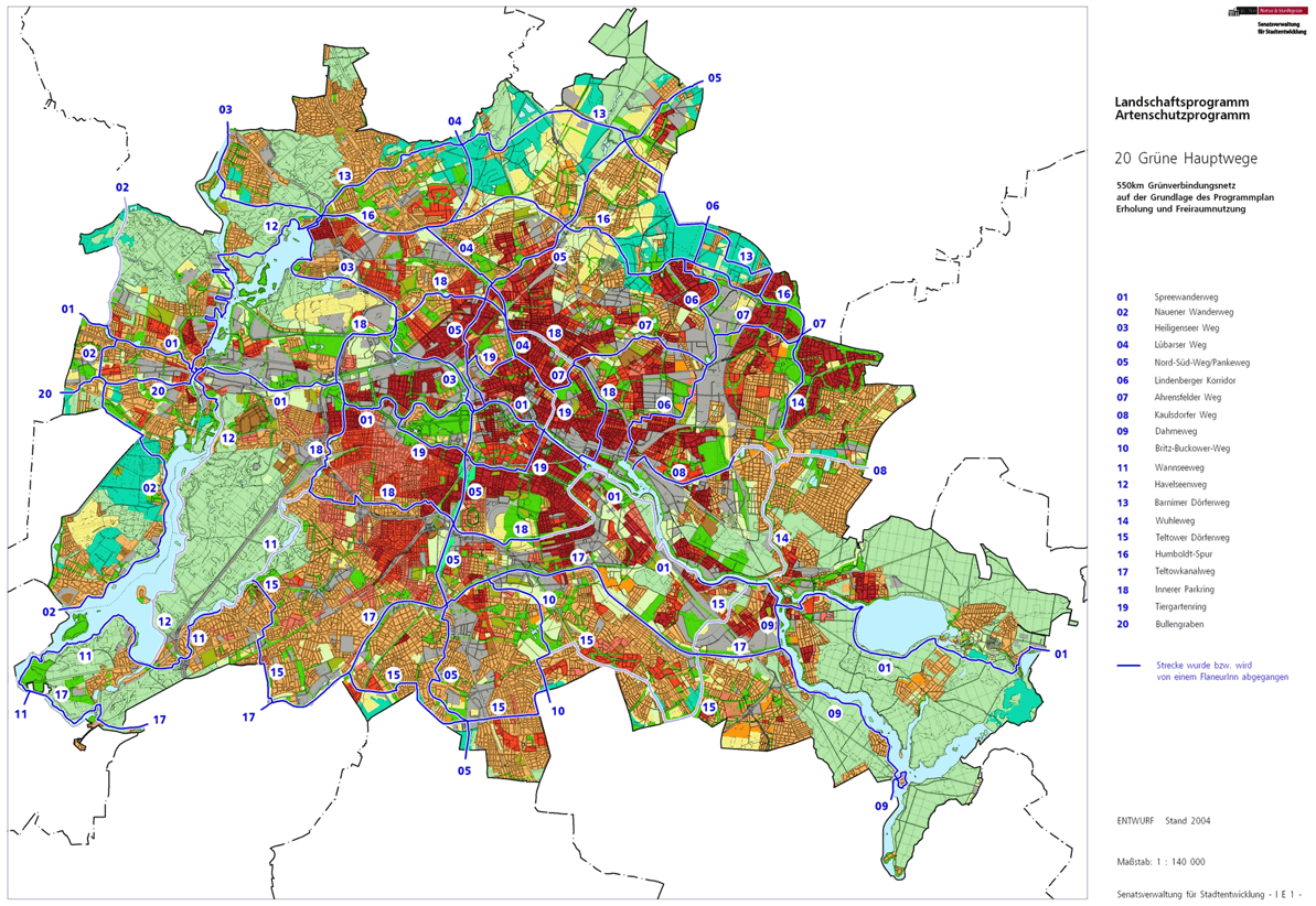
The Inner Parkring , number 18, is one of the 20 main green routes in Berlin . This is a compilation of 20 hiking trails through the Berlin urban area with a total length of around 550 kilometers. The aim is to link “residential areas with the diverse recreational opportunities in parks and local recreation areas in Berlin and Brandenburg ” (Senate Department for Urban Development and the Environment). The pedestrian should have the opportunity to “experience the city intensely as a combination of culture, history and ecology”.
course
The 52 kilometer long park ring surrounds the Berlin city center and connects large and small parks with green niches in the city, such as the large open space of the former Tempelhof Airport . The extensive Volkspark Wilmersdorf was created at the beginning of the 20th century in an ice age channel . The Volkspark Jungfernheide in the northwest is the second largest park in Berlin and was laid out in the 1920s on 146 hectares of forest area that stretched from the city center to Spandau. The route goes through the urban districts of Wedding , Gesundbrunnen and Prenzlauer Berg . In the east in Friedrichshain and the Kreuzberger Wrangelkiez there are cafes and restaurants on the way. The circle closes on the banks of the Landwehr Canal and the Neuköllner Schifffahrtskanal .
“Immediately around the densely built-up inner city of Berlin is a ring of public parks, allotment gardens and cemeteries, the 'Inner Parkring'. Thanks to forward-looking urban development planning in the 1920s, it was created and secured as a contribution to healthy living and working conditions for all Berliners. New parks such as the Mauerpark and the Schöneberger Südgelände Nature Park complement the historic ones . "( Stadtentwicklung.berlin.de :)
The following description of main path 18 runs to the right from Tempelhofer Feld through the districts and back to Tempelhofer Feld.
Tempelhof

The (after the FIS broker information) defined southern starting point ( map ) for the inner ring Park, the green main path 18, is located in Tempelhof on the grounds of the former airport Tempelhof . This point is easily accessible from the Tempelhof S-Bahn and U-Bahn station . After the final abandonment of the airport, this area, which was initially a military training area for the Prussian troops, is also known as Tempelhofer Freiheit . The route of the main path is described in this article in a clockwise direction. First of all, it leads over the (former) southern runway , a 50-meter-wide concrete belt . This path, which is also suitable for skaters , is already in the Tempelhof area with the last 250 meters over the district boundary.
Neukölln


At the end of the former airport site, you go to the Neukölln district . From now on it goes over an intermediate part of the Oderstraße (because of the joint movements for motor vehicles at that time) , the Kirchhofweg leads between the former St. Thomas Kirchhof and the "Kirchhof V der Jerusalem- und Neue Kirchgemeinde" through to Hermannstraße am U -Bahnhof Leinestrasse . Crossing the street, the path continues in Thomasstraße to the Thomas-Höhe park . The street is accompanied to the left of St. Thomas Kirchhof by the park of Thomas-Höhe and to the right by residential buildings ( Altenbraker - and Ilsestrasse ). A little off the beaten track via Selkestrasse or Rübelandstrasse , the Körnerpark is located in the south . The Mittelweg comes from the left and shortly afterwards you have to cross Karl-Marx-Straße at Karl-Marx-Platz and walk to old Neukölln ( Rixdorf and Böhmisch-Rixdorf) at Richardplatz . At the pedestrian zone Richardplatz, Schierker- , Richard- , Zwiestädter and Schudomastraße are touched and crossed, then the main path leads to the left within the pedestrian zone through the Hertzbergstraße and over the Böhmische Straße . About the Sonnenallee crossing the main trail number 18 on the green Hertzbergplatz in the Treptow road , after crossing from Stuttgart , Weser and Werra road before will Treptow Bridge the Weigand road to the west left of the Neukölln shipping canal committed along. Ulsterstrasse , Roseggerstrasse , a football and playground, lead to the left , then the Truseweg . At the Innstraße leads Else bridge over the channel to Elsenstraße , followed by the intersection with the Wildenbruchstraße with the Wildenbruchbrücke and the same road .
On the Fuldastraße the further way remains over the Weichselplatz to the corner Weichselstraße , on the water side the shipping canal goes into the Landwehrkanal , northwards to the Spree and westwards it runs through the city center , first to Kreuzberg . The north corner of Weichselplatz on the banks of the Neukölln shipping canal is at the transition from Weichselstrasse to Maybachufer , which forms the border with Kreuzberg. The main path leaves the district here.
Alt-Treptow

The Inner Parkring follows over the Lohmühlenbrücke to Lohmühlenplatz ( maps ). This forms the border triangle between Neukölln, Kreuzberg (to which the water bodies belong) and the district of Alt-Treptow (on the north, east edge of the square), so that the main route meets the Berlin Wall Trail here . In Alt-Treptow, these two paths go together at the green corridor (formerly the stand area of the Berlin Wall ) on the east side of the Landwehr Canal to the north, the entire adjacent water area belongs to Kreuzberg. A subsequent bridge ( Lohmühle Ufer bridge ) formerly led the Görlitzer Bahn to Görlitzer Bahnhof . The train station no longer exists apart from a few remains of the wall, and so the Görlitzer Park, which is important for the densely built-up Kreuzberg, is located on the site . The bank of the flood ditch forces the main green path to the right, while the Landwehr Canal continues straight on to the left. In the course of Lohmühlenstrasse , the district is left with the Treptower Bridge.
Kreuzberg

When you step onto the Treptower Bridge, you enter the Kreuzberg district . After the bridge, the path leads to the left through a small bush, to the right you can reach the Silesian Bush with one of the last watchtowers from the time of the Wall . The Inner Parkring uses the Ernst-Heimann-Steg over the Landwehr Canal to the Görlitzer / Heckmann-Ufer . The route takes the third direction of Taborstrasse (Taborkirche) in the arch to Wrangelstrasse . This is less busy than the parallel Schlesische Straße , but also leads through residential areas with old buildings. After Cuvrystraße , path 18 leads into Falckensteinstraße to the right over Schlesische Straße to the Spree. This is where the Oberbaumstrasse runs , over which the subway runs as an elevated railway over the Spree to the Warschauer Strasse subway station . The previous subway station Schlesisches Tor was the end of subway line 1 until the 1990s , as it had been interrupted since 1961 due to the construction of the wall . Here the Inner Parkring leaves Kreuzberg, because the Spree already belongs to the neighboring district.
Friedrichshain

On the bank of the Spree, the district of Friedrichshain is entered with the Oberbaumbrücke . The Oberbaumbrücke brings the Inner Parkring to the Spreenordufer, where the Spreeweg / Berliner Urstromtal leads along to the left. The short stretch of road on the land side, Am Oberbaum , is first taken on the B 96a to the right to the bank of the Spree. The Spreeweg and the Wall Trail lead along the banks of the Spree to the west (along the left) to the East Side Park and the wall art of the East Side Gallery . The other branch of Hauptweg 01 (Spreeweg) (eastward) and the Inner Parkring share the riverside path and separate again after 560 meters. The Spreeweg continues on the bank and the Parkring goes away from the bank. This point, the Spree opposite to the piece of land which lies between the outflow channel and Landwehr Flutgraben in height of the Modersohnstraße ( cards ). This street is next to the MTV Networks Germany building from the bank of the Spree to the north. A set of traffic lights to Modersohnstraße helps to cross the six-lane Stralauer Allee , which now serves as a route from the Spree to the Inner Parkring. On Corinthstrasse , Rudolfplatz (with sports and playground) with Rudolfstrasse on its north side is crossed before the Modersohn Bridge is reached. This bridge, with its bridge ramps, is almost 200 meters long and leads over the railway line between the S-Bahn stations Warschauer Straße and Ostkreuz . At the intersection of Revaler Straße , Hauptweg 18 continues straight ahead and at the beginning of Gärtnerstraße, turn left into Simplonstraße to Wühlischstraße through Friedrichshain's old buildings. Wühlischstraße is used to the left and before its name change to Kopernikusstraße with the continuous tram line M13, Simon-Dach-Straße with its trendy restaurants and old trees is reached. On this street it goes past Krossener Strasse , over Grünberger and Boxhagener Strasse into Niederbarnimstrasse to Frankfurter Allee (B 1 / B 5)
The underground line of the U5 line between the Frankfurter Tor underground station and Samariterstraße is located under Frankfurt Allee . The residential buildings at this intersection to Proskauer road separate the magnificent buildings of the 1950s the former Stalin Allee from the old buildings. About Riga street away and at the Schreinerstraße past is at the Bänschstraße the Forckenbeckplatz achieved with its green spaces and obliquely through the Eldenaer road crossing in addition, here, the district is left.
Prenzlauer Berg
.JPG)

When you cross Eldenaer Straße, you enter the Prenzlauer Berg district ( Pankow district ), also called PrenzlBerg , on its north side ( maps ) . On the following park / meadow area between August-Lindemann -Strasse and Richard-Ermisch-Strasse was Berlin's central cattle yard until the 1990s . With a left-right tour through the park, the green corridor between Zur Börse and Zur Marktflagge is used for the green Hauptweg 18. The Thaerstraße is crossed and on the Otto-Ostrowski Street between green areas and residential buildings ( Kurt-Exner , Anna-Wabnitz Street ) walking the corner Hermann-Blankenstein-Straße reached. On the latter street to the right, the main path 18 runs to the route of the Stadtbahn , in order to find the path under Landsberger Allee (opposite the S-Bahn station of the same name ) on the north side of the swimming / sports hall and velodrome ( Europa-Sport-Park ; previously stood here the Werner-Seelenbinder-Halle ) to Werner-Heyse-Straße and through the following sports fields and halls to Conrad-Blenkle-Straße .
The ideal route of the inner park ring between the sports facility and the S-Bahn route is not accessible. At the Kniprodestrasse to the right, the Inner Parkring leads into the Volkspark Anton Saefkow and has a short common section with the Hauptweg 7 ( Hönower Weg ). However, Hauptweg 18 continues parallel to Anton-Saefkow-Straße through the green corridor to the west and crosses Greifswalder Straße (near the S-Bahn station of the same name ) into Ernst-Thälmann-Park (formerly the location of the gas works) and around the high-rise on the Lilly-Henoch-Strasse around. Within the park area, the path follows - past the Zeiss large planetarium - to Prenzlauer Allee , which is to be crossed a little south of the S-Bahn station of the same name . In streets parallel to the S-Bahn route ( Ahlbecker , Duncker- , Stargarder Straße , across Pappelallee with tram line 12), the main path leads to the Gethsemane Church , which is bypassed on Gethsemanestraße (at the back) so that through the S-Bahn station Schönhauser Allee is reached through Schönhauser Allee on the north side of the S-Bahn. The main route continues through the viaduct of the Pankower U-Bahn elevated railway through Dänenstrasse .
The ideal route along the S-Bahn branch between the ring line and the north-south line is not accessible because of the BSR recycling yard located here . The Innere Parkring goes right into Malmöer Straße to Behmstraße / Schivelbeiner Straße , to the left the Behmstraße ( maps ) is used to the Behmstraße bridge , where it meets the Lübarser Weg (Hauptweg 04) and the Mauerweg. All three routes use the ramp down to Norwegerstrasse and under the Bösebrücke at Platz des November 9, 1989 (above: Bornholmer Strasse with connection to Bornholmer Strasse S-Bahn station ) through ( maps ) to a green corridor that was created after the wall was torn down is designated as a landscape protection area.
Pankow
When you enter the Esplanade , the main path from Prenzlauer Berg leads to the southwest of the Pankow district. At the Eschengraben to the left (westwards) there is a railway passage as an extension of the esplanade. The railway underpasses south of the Nassen Dreieck through the Stettiner Bahn and the Berliner Nordbahn are in the Pankow district (Pankow district). The wet triangle was created by the third track on the northern edge as a connection between the two railway lines. As the area of the Berlin Wall , which was demolished in 1990 , the further use of the area is still under discussion.
Healthy well

At the end of the underpass through the Nordbahn (S-Bahn line Tegel and Oranienburg) there is a transition to the district of Mitte to the district of Gesundbrunnen . Around the KGA 'Grüntal' the ways separate again. While Lübarser Weg and Mauerweg go north into Steegerstraße , Innere Parkring turns south into a parking strip on Grüntaler Straße . After 320 meters in Gesundbrunnen, it turns right into Soldiner Strasse and then right again at Freienwalder Strasse to Sophienkirchhof III . Then within the cemetery area to the left to St.-Elisabeth-Kirchhof II , through which the Wollankstrasse is reached. Across this 110 meters to the north (to the right) is the entrance to the churchyard of the French community III . Main path 18 goes through this to the rain retention basin ('Franzosenbecken' or 'Pankegrundbecken') on the Panke . On the Panke to the south, together with the north-south path (main path 05), it goes to the Heubuder Steg . On the Panke-Hauptweg further along the Panke, the Innere Parkring crosses the Panke to Heubuder Straße and uses a small garden path (Fechhauser Weg) a little up the pank through the KGA 'Pankegrund' to the west across the Koloniestraße through the KGA 'Sommerglück'. At the end of the garden, the path meets the turning area ( maps ) of the paper road . The Inner Parkring leaves the district at the end of Paper Street.
Reinickendorf

At the corner of Paper Street / provincial road , the change from Gesundbrunnen in the hamlet is Reinickendorf . The Inner Parkring now does not lead to the opposite Pankower Allee with trees on the median, but to the left to Holzstrasse , crosses Provinzstrasse here and uses Letteallee (via Reginhardstrasse , Mickestrasse , Letteplatz , Kühleweinstrasse ) to the green area at Franz-Neumann-Platz to the right to the entrance to the underground station (on Pankower Allee). The traffic lights make it easier to cross Residenzstraße (section of the B 96 ) to Am Schäfersee street . In the green area, the Schäfersee on the north bank is circled with the Schäferseepark and along the KGA 'Am Schäfersee' (with Baseler Strasse ) on the Grindelwaldweg, the tree-lined Aroser Allee is crossed. The cemetery of the Golgotha, Gnaden and St. Johannes Evangelist congregations is bypassed in the north by the Schwarzen Graben on the Romanshorner Weg , Zermatter Straße between the residential buildings to a green area on the Schwarzen Graben. The marked northern entry point ( maps ) into the Ringweg is located here.
This point can be reached from the Gotthard - corner of Teichstraße or via Julierstraße . A green corridor in the extension of Teichstraße (from Gotthardstraße) at the bridge over the Black Trench ( maps ) leads the Inner Parkring west of the cemetery areas to Holländer Straße . The district is left on the south side.
Wedding

Holländerstraße forms the Reinickendorf district border (to which the street area belongs) to Mitte , from the Reinickendorf district to Wedding . In Wedding, the KGA 'Freudental' goes with an arc to the west around the houses number 77, 77a, 77b and further on the edge of the Domfriedhof II and at the Center Francais de Berlin to Müllerstrasse (corner of Londoner Strasse ). Here is located on the corner of Dublin Street of Rehberge underground station . The main path crosses Müllerstraße to Petersallee and in the course of which it crosses African Straße (corner of Togostraße ) at Nachtigalplatz . At the end of Petersallee at the corner of Windhuker Straße , Volkspark Rehberge between LSG Sperling- and Möwensee is reached. The path then continues straight to the southwest, along with the main path 03 (Heiligenseer Weg) from the transition to the LSG past the fallow deer enclosure, pheasantry, wild boar enclosure to the badger mountains. While Lübarser Weg leads eastwards to the Dohnagestell , the Parkring turns west over the Schwarzen Graben to the KGA 'Steinwinkel' on Charles-Corcelle-Ring , whose name reminds us that Wedding belonged to the French sector . The main path together with the Berlin – Copenhagen cycle path runs through the KGA 'Quartier Napoléon' and at the sports facility around the Stade Napoléon on the Allée du Stade east of the central fairground to the bank of the Berlin-Spandau shipping canal . The district border between Mitte and Charlottenburg-Wilmersdorf , which separates the districts of Wedding and Charlottenburg-Nord , runs along the Uferweg . Even before the Hinkeldeybrücke, the district border crosses the shipping canal, so the riverside path already belongs to the neighboring district. The ascent to the byway next to the motorway is actually in the Tegel district .
Charlottenburg-North

The Hinkeldeybrücke ( Lage ) is reached on the bypass of the motorway . The long-distance cycle path R1 remains on the riverside path. Next to the Hinkeldey bridge, a ramp and stairs lead to the adjacent pedestrian crossing. The bridge leads the A 111 (motorway feeder towards Hamburg , E 26) as an extended Kurt-Schumacher-Damm and thus also the Inner Parkring over the shipping canal and the Saatwinkler Damm . Here the main path leads over the parking lot at junction 10 through the bridge (near Tegel Airport ) to the west. Immediately afterwards, turn left across the green area within the south-west branch of junction 11 (Tegel Airport) and through the motorway access to the LSG Volkspark Jungfernheide . The route leads south, close to the autobahn, to Heckerdamm (east of junction 12 [Heckerdamm]) and into the Heilmannring residential area (past Habermann- , Hofacker- and Dahnendorfzeile ) and over the U7 underground line (near Halemweg underground station ) in the curve the road to Letterhausweg ( maps ), which is taken to the left. The Siemensdamm is from Letterhaus- for Nicholas United Way crosses. On the northeast corner of the intersection of the district begins Siemensstadt ( Spandau district ), however, the interior Parkring on the north-Charlottenburg side left in the Nonnendamm . This is the historic route south around the Nonnenwiesen that has been replaced by Siemensdamm. Before the bridge to the Schleuseninsel, the main path leads under the motorway on the north bank of the Neue Schleuse and the Westhafenkanal to Tegeler Weg .

The "ideal tour of the park ring" should follow the Nonnendamm over the bridge. The section of the street with historical pavement south of the lock Charlottenburg on the Westhafenkanal and the KGA 'Bleibtreu II' and north of the Spree is accessible. The old lock Charlottenburg in the district of Charlottenburg blocks the way to the Spreeinsel, from which it over the weir that the Spree provides the way to the locks. With the appropriate conversion of the Spree weir, the south bank would be reached, where the Spreeweg / Berliner Urstromtal on the riverside path around the KGA 'Schleusenland' and under the Jungfernheide railway bridge could lead the Hauptweg 18 in the Charlottenburg palace garden to its (temporary) bypass.
The Inner Parkring (status: 2014) remains on the way through the A 100 in Charlottenburg-Nord north of the Charlottenburg lock and the Westhafenkanal and uses the side path to Tegeler Weg , a 40 meter wide two-lane two-lane road. Without crossing it, the main path 18 leads over the Mörschbrücke and the path down to the banks of the Spree / Westhafenkanal and the district boundary is on this bank path, so that the district is left before the railway bridge. This riverside path opposite the Schleuseninsel is part of the “Uferweg Charlottenburger Insel”, which leads south and east on the Spree to the Spreekreuz (where the Landwehr Canal joins ), north on the Charlottenburg connecting canal and finally back west on the Westhafen Canal .
Charlottenburg

.jpg)
About 20 meters before the railway bridge on the Uferweg it goes to the district of Charlottenburg . Under the six-track railway bridge it goes over stairs to the pedestrian bridge next to the Spree railway bridge to the obelisk in the Charlottenburg palace garden . Together with the Spreeweg and the European long-distance hiking trail E11 , the route is located in the castle garden near the west bank of the Spree to the south, past the carp pond on the right. On Schinkel Pavilion before Schloßbrücke the main ways again, the Inner Ring Park to Luisenplatz leads to the Schloss Charlottenburg to Spandau dam . Between the Berggruen Museum and the Scharf-Gerstenberg Collection on the green median of Schloßstraße to the intersection with Zille- / Knobelsdorffstraße to the right to Kläre-Bloch-Platz . From the square, Wundtstraße leads diagonally to the southwest to Kaiserdamm (near the Sophie-Charlotte-Platz underground station ). On the Kaiserdamm a portion extending Bundesstrasse 1 / 5 . Via Kaiserdamm to Witzlebenstrasse , you reach the Lietzenseepark at Erwin-Barth-Platz (green section in Wundtstrasse in the park), where you walk across the Lietzensee on the north and west banks, passing under the Lietzenseebrücke . At the southern end of the lake, at the terrace, you reach Dernburgstrasse , which, after it has been crossed, leads into Rönnestrasse . Between Rönnestraße (south side) and the railway site, the main path leads along the border between Charlottenburg and Halensee to the railway underpass (still in Charlottenburg) on Holtzendorffstraße to Kracauerplatz , this square is in Charlottenburg, where Hauptweg 18 leaves the district.
Halensee

From Kracauerplatz , turn right into Heilbronner Strasse into the Halensee district . In addition to the Lützenstrasse railway farm at the end of Heilbronner Strasse, the main path leads to the left through Georg-Wilhelm-Strasse to Henriettenplatz on Kurfürstendamm . Continue to the right to the Kurfürstendamm bridge over the city ring road , behind the bridge to the right into Bornstedter Straße , from which a path leads to the pedestrian bridge ( Trabener Steg ) over the two branches of Halenseestraße and the city motorway .
Grunewald

At the eastern end of the Trabener Steg, which is next to the railway bridge, you change from Halensee to the Grunewald district . In Grunewald, the path meets the railway agriculture (BLW) 'Trabener Straße' and continues through Friedenthalpark to the shores of Lake Halensee . Across from the island in Halensee, take stairs to Trabener and Erbacher Strasse , past Niersteiner Strasse , across Erdener Strasse and to the start of Hauptweg 11 ( Wannseeweg ). Both paths lead on the east bank of the Koenigssee to Koenigsallee and over the Koenigsalleebrücke with the confluence of Hertha and Koenigssee. The Wannseeweg continues to the west and the Inner Parkring to the east on Delbrückstrasse , Bismarckstrasse and through the Bismarckbrücke on the south bank of the Hubertussee to Hubertusallee . The Hubertusallee is crossed to the sloping Franzensbader Straße and along the district boundary to Schmargendorf am Talgraben (with its connection to Hubertussee ) the main path continues through Reinerzstraße to Auguste-Victoria-Straße after which the district is left.
Schmargendorf
When you cross Auguste-Victoria-Straße, Schmargendorf is reached and the extension of Reinarzstraße leads into the park on Flinsberger Platz again brings a ' park feeling' before it goes over Hohenzollerndamm through Landecker Straße via Cunostraße and through Fritz-Wildung-Straße again passes in green spaces and sports facilities. The sports field Wilmersdorf it goes to the left inter alia on the Talgraben away to high arc , a strained steel girder bridge over beltway and the parallel annular track . The boundary of the district is such that the motorway section of the bridge belongs to Schmargendorf.
Wilmersdorf

On the bridge, you will change from Schmargendorf to Wilmersdorf above the motorway and the ring railway . On the Wilmersdorfer side (from the railway section of the bridge) the path leads to Rudolstädter Straße , on which the motorway access from junction 1 ( Konstanzer Straße ) to the Wilmersdorf junction (A 100 with A 103 and A 104 ) is crossed. At the corner of Kalischer Straße , the main path continues on the southern edge of the Wilmersdorf cemetery and on the northern bank of the Fennsee through the Wilmersdorf park . Interrupted the green space by the bar street ( Barbrücke ), the intersection Mecklenburg / Uhlandstrasse and Blissestraße (360 meters from Blissestraße ) which spanned with a footbridge Federal Avenue (450 meters to Berliner Straße and south 630 meters from the S - and Metro station Bundesplatz ) acting as bicycle road trained Prinzregentenstraße . The Kufsteiner Straße is not passed through the Volkspark Wilmersdorf as a traffic road, but the district border between Charlottenburg-Wilmersdorf and Tempelhof-Schöneberg lies on this route and the district is left.
Schöneberg

With the district change, the district change to Schöneberg is on the Inner Parkring. From the district border (Wilmersdorf / Schöneberg) on Kufsteiner Straße you continue in the Volkspark, which is called Rudolf-Wilde-Park in the district and is crossed by the (here car-free) Innsbrucker Straße with the underground line U4 . At the Ententeich, the Rathaus Schöneberg underground station offers another option for entering or exiting the Inner Parkring. Head east for 200 meters to the east end of the park on Martin-Luther-Straße with John-F.-Kennedy-Platz in front of Schöneberg Town Hall . Martin-Luther- and Dominicusstraße have to be crossed in order to reach Belziger Straße , which branches off here to the northeast . From here to the right you will reach Heinrich-Lassen-Park , through which you will find Bundesstrasse 1 ( main road ). The green main path continues diagonally to the left and at the level of Albertstraße crosses the main road in front of the square, Albertstraße over Feurigstraße to Ebersstraße and on this further to the left. At the Teltow elementary school, a transition leads over the S-Bahn line of the S1 line to the lawn called Cheruskerpark north of the event hall of the former gasometer . On Cheruskerstraße to Leuthener Straße, turn left across Gotenstraße , Leberstraße , Gustav-Müllerstraße and Naumannstraße between residential houses on the street, where the north-south path (green main path 05) is crossed. Through the green wasteland with the Hertha-block promenade , the Wilhelm-Kabus Street crossing and the way to Alfred Lion bridge committed. To the north of the Südkreuz S-Bahn and long-distance train station , this footbridge leads first over the double-track S-Bahn and then over the four-track long-distance train route.
Tempelhof

At the end of the Alfred-Lion-Steg the Parkring changes over the railway area from Schöneberg to Tempelhof on General-Pape-Straße . Straight on Hertha-block promenade of the way into the lead Gontermannstraße to Loewenhardtdamm dam and on this right to the park ring in the garden city of Neu-Tempelhof . Following the Parkring to the right ( Bäumer- and Rumeyplan ) you will reach the intersection Bundesring / (Rumeyplan) - Peter-Strasser-Weg over Manfred-von-Richthofen-Straße and continue along this route. The main route 15 meets the Tempelhofer Damm ( B 96 ), which now has to be negotiated over to the former airfield . Tempelhofer Freiheit can be entered at the previously closed driveway to the airport site. The Paradestrasse underground station ( line U6 ) is located 220 meters further north at the airport building , the longest building in Europe . On the now accessible area of freedom, a path leads to the western end of the northern runway and further over the former runway to the west end of the south concrete runway where the Park ring ends (as defined in the FIS-Broker) or has its southern entry point. 200 meters from Tempelhofer Damm is the Tempelhof train station with a connection to the Ringbahn (lines S41, S42, S45 and S46) and the underground line U6 .
Local transport connections
The Berlin rail network of the public transport is accessible from the interior Park ring by its center curve at multiple stations.
- S + U-Bahnhof Tempelhof
- Südkreuz S-Bahn station
- Schöneberg S-Bahn station
- Rathaus Schöneberg underground station
- Halensee S-Bahn station
- Berlin Messe Nord S-Bahn station
- Jungfernheide S + U station
- Rehberge underground station
- Franz-Neumann-Platz underground station
- Bornholmer Strasse S-Bahn station
- S + U-Bahnhof Schönhauser Allee
- Prenzlauer Allee S-Bahn station
- Greifswalder Straße S-Bahn station
- Frankfurter Allee S-Bahn station
- Samariterstraße underground station
- Schlesisches Tor underground station
- Leinestrasse underground station
literature
- Hiking map Berlin City. Strolling - walking - hiking . 1st edition. piekart, Berlin 2012, ISBN 978-3-935863-22-3 .
Web links
- 20 Green Main Paths , website of the Berlin Senate Department for Urban Development and the Environment, accessed on January 5, 2014.
- Overview map of the 20 hiking trails , website of the Berlin Hiking Association, accessed on January 5, 2014.
- Claudia Lenk: Interesting facts about the 20 main green paths .
Individual evidence
- ↑ a b path number: 18
- ↑ FUSS e. V.
- ↑ The BUND project "20 Green Main Paths"
- ↑ Project "20 Green Main Paths® in Berlin"
- ^ Association for hiking in the LSB Berlin
- ↑ Senate Department for Urban Development and the Environment , Unit IE Nature Conservation, Landscape Planning and Forestry
- ↑ Chronicle of the 20 green main routes on berlin.de
- ↑ 20 main green paths. In: Website of the Berlin Senate Department for Urban Development and the Environment. Retrieved January 31, 2017 .
- ↑ The BUND project “20 main green paths”. In: BUND website . Retrieved January 31, 2017 .
- ↑ : 20 green main paths®> The planning basis
- ↑ a b c d FIS broker map display 20 green main routes - digital hiking map , since May 2014 the recommended routes have been marked in blue, plan routes that can be walked on are red and if not passable: red dashed

01 Spreeweg | 02 Spandauer Weg | 03 Heiligenseer Weg | 04 Lübarser Weg | 05 North-South Path | 06 Lindenberg Corridor | 07 Hönower Weg | 08 Kaulsdorfer Weg | 09 Dahmeweg | 10 Britz-Buckower Weg | 11 Wannseeweg | 12 Havelseenweg | 13 Barnimer Dörferweg | 14 Wuhletal hiking trail | 15 Teltower Dörferweg | 16 Humboldt track | 17 Teltow Canal Path | 18 Inner parking ring | 19 Tiergartenring | 20 Bullengrabenweg