
Sugarloaf Mountain (Utah)
| Sugarloaf Mountain | |
|---|---|
.jpg) North aspect | |
| Highest point | |
| Elevation | 11,051 ft (3,368 m)[1] |
| Prominence | 551 ft (168 m)[1] |
| Parent peak | Mount Baldy[1] |
| Isolation | 0.71 mi (1.14 km)[1] |
| Coordinates | 40°33′57″N 111°37′29″W / 40.5658608°N 111.6248150°W[2] |
| Naming | |
| Etymology | Sugarloaf |
| Geography | |
 Sugarloaf Mountain Location in Utah  Sugarloaf Mountain Sugarloaf Mountain (the United States) | |
| Country | United States |
| State | Utah |
| County | Salt Lake / Utah |
| Parent range | Wasatch Range[3] Rocky Mountains |
| Topo map | USGS Brighton / Dromedary Peak |
| Climbing | |
| Easiest route | class 1+ hiking[1] |
Sugarloaf Mountain is an 11,051-foot-elevation (3,368-meter) summit on the boundary that Salt Lake County shares with Utah County, in Utah, United States.
Description[edit]
Sugarloaf Mountain is located 20 miles (32 km) southeast of downtown Salt Lake City at the Alta Ski Area in the Wasatch–Cache National Forest.[3] The peak is set in the Wasatch Range which is a subset of the Rocky Mountains. Precipitation runoff from the mountain's north slope drains to Little Cottonwood Creek, whereas the south slope drains to American Fork River. Topographic relief is significant as the summit rises 2,250 feet (686 meters) above American Fork Canyon in one mile (1.6 km). This mountain's toponym has been officially adopted by the United States Board on Geographic Names.[2]
Climate[edit]
Sugarloaf Mountain has a subarctic climate (Köppen Dfc), bordering on an Alpine climate (Köppen ET), with long, cold, snowy winters, and cool to warm summers.[4] Due to its altitude, it receives precipitation all year, as snow in winter, and as thunderstorms in summer. There is no weather station at the summit, but this climate table contains interpolated data for an area around the summit.
| Climate data for Sugarloaf Mountain (Alta) 40.5641 N, 111.6236 W, Elevation: 10,482 ft (3,195 m) (1991–2020 normals) | |||||||||||||
|---|---|---|---|---|---|---|---|---|---|---|---|---|---|
| Month | Jan | Feb | Mar | Apr | May | Jun | Jul | Aug | Sep | Oct | Nov | Dec | Year |
| Mean daily maximum °F (°C) | 26.1 (−3.3) |
27.3 (−2.6) |
32.2 (0.1) |
38.1 (3.4) |
47.5 (8.6) |
59.0 (15.0) |
68.3 (20.2) |
66.6 (19.2) |
57.8 (14.3) |
44.8 (7.1) |
33.3 (0.7) |
26.4 (−3.1) |
44.0 (6.6) |
| Daily mean °F (°C) | 17.9 (−7.8) |
18.1 (−7.7) |
22.7 (−5.2) |
27.8 (−2.3) |
37.0 (2.8) |
47.6 (8.7) |
57.1 (13.9) |
55.7 (13.2) |
47.3 (8.5) |
35.1 (1.7) |
24.8 (−4.0) |
18.1 (−7.7) |
34.1 (1.2) |
| Mean daily minimum °F (°C) | 9.8 (−12.3) |
8.9 (−12.8) |
13.3 (−10.4) |
17.6 (−8.0) |
26.4 (−3.1) |
36.1 (2.3) |
45.9 (7.7) |
44.8 (7.1) |
36.7 (2.6) |
25.4 (−3.7) |
16.2 (−8.8) |
9.8 (−12.3) |
24.2 (−4.3) |
| Average precipitation inches (mm) | 7.05 (179) |
6.03 (153) |
6.09 (155) |
5.91 (150) |
4.32 (110) |
1.95 (50) |
1.32 (34) |
2.11 (54) |
2.83 (72) |
4.13 (105) |
5.18 (132) |
6.08 (154) |
53 (1,348) |
| Source: PRISM Climate Group[5] | |||||||||||||
Gallery[edit]
-
 Northwest aspect
 -
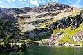
 Sugarloaf Mountain and Cecret Lake
 -
 Sugarloaf Mountain and Cecret Lake
 -
 Northeast aspect
 -
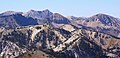 Sugarloaf Mountain (center), Sunset Peak front left, Twin Peaks behind left, Mount Baldy to right. Viewed from Clayton Peak.
 -
 West aspect of Sugarloaf, with Devils Castle (behind, right)
 -
 Cecret Lake and Sugarloaf


References[edit]
- ^ a b c d e "Sugarloaf Mountain - 11,051' UT". listsofjohn.com. Retrieved 2024-06-03.
- ^ a b "Sugarloaf Mountain". Geographic Names Information System. United States Geological Survey, United States Department of the Interior. Retrieved 2024-05-31.
- ^ a b "Sugarloaf Mountain, Utah". Peakbagger.com. Retrieved 2024-06-03.
- ^ Peel, M. C.; Finlayson, B. L.; McMahon, T. A. (2007). "Updated world map of the Köppen−Geiger climate classification". Hydrol. Earth Syst. Sci. 11. ISSN 1027-5606.
- ^ "PRISM Climate Group, Oregon State University". PRISM Climate Group, Oregon State University. Retrieved November 6, 2023.
To find the table data on the PRISM website, start by clicking Coordinates (under Location); copy Latitude and Longitude figures from top of table; click Zoom to location; click Precipitation, Minimum temp, Mean temp, Maximum temp; click 30-year normals, 1991-2020; click 800m; click Retrieve Time Series button.
External links[edit]
- Sugarloaf Mountain: weather forecast
- National Geodetic Survey Data Sheet
Places adjacent to Sugarloaf Mountain (Utah) | ||||||||||||||||
|---|---|---|---|---|---|---|---|---|---|---|---|---|---|---|---|---|
| ||||||||||||||||