
Fort Delimara: Difference between revisions
Xwejnusgozo (talk | contribs) No edit summary |
|||
| (44 intermediate revisions by 15 users not shown) | |||
| Line 1: | Line 1: | ||
{{Infobox military installation |
{{Infobox military installation |
||
|name = Fort Delimara |
|name = Fort Delimara |
||
|native_name = Il-Fortizza ta' Delimara |
|||
|ensign = |
|||
|native_name = |
|||
|partof = <!-- for elements within a larger site --> |
|||
|location = [[Marsaxlokk]], [[Malta]] |
|location = [[Marsaxlokk]], [[Malta]] |
||
| ⚫ | |||
|nearest_town = <!-- used in military test site infobox --> |
|||
| |
|image_size = 300px |
||
| ⚫ | |||
|alt = |
|||
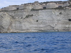
|caption = Casemates of Fort Delimara |
|caption = Casemates of Fort Delimara |
||
|image2 = <!--secondary image, major command emblems for airfields --> |
|||
|alt2 = |
|||
|caption2 = |
|||
|type = [[Polygonal fort]] |
|type = [[Polygonal fort]] |
||
|coordinates = {{coord|35|49|26|N|14|33|27|E|display= |
|coordinates = {{coord|35|49|26|N|14|33|27|E|display=inline|region:MT_type:landmark_source:GNS-enwiki}} |
||
|ownership = [[Government of Malta]] |
|||
|latd = | latm = | lats = | latNS = |
|||
|controlledby = [[Heritage Malta]] |
|||
|longd = | longm = | longs = | longEW = |
|||
|coordinates_type = <!--airport, fort, etc. --> |
|||
|coordinates_region = |
|||
|image_map = |
|||
|image_mapsize = |
|||
|image_map_alt = |
|||
|image_map_caption = |
|||
|pushpin_map = |
|||
|pushpin_mapsize = |
|||
|pushpin_map_alt = |
|||
|pushpin_map_caption = |
|||
|pushpin_relief = |
|||
|pushpin_image = |
|||
|pushpin_label = |
|||
|pushpin_label_position = |
|||
|pushpin_mark = |
|||
|pushpin_marksize = |
|||
|ownership = <!-- government department such as the MoD or the United States DoD --> |
|||
|operator = <!-- where different from ownership such as the RAF or the USAF --> |
|||
|controlledby = <!-- such as RAF Bomber Command or the Eighth Air Force --> |
|||
|open_to_public = No |
|open_to_public = No |
||
| ⚫ | |||
|site_other_label = <!-- for renaming "Other facilities" in infobox --> |
|||
|used = 1880s–1950s |
|||
|site_other = <!-- for other sorts of facilities - radar types etc --> |
|||
|site_area = <!-- area of site m2, km2 square mile etc --> |
|||
|code = <!--facility/installation code, applies to US --> |
|||
| ⚫ | |||
|used = 1880s-1950s |
|||
|builder = [[British Empire]] |
|builder = [[British Empire]] |
||
|materials = [[Limestone]] and [[Concrete]] |
|materials = [[Limestone]] and [[Concrete]] |
||
|site_area = {{convert|24000|m2|abbr=on}}<ref>{{cite web|title=The American University of Malta - Preliminary Alternative Sites Evaluation Report|url=https://opm.gov.mt/en/Documents/AUM/Preliminary%20Alternative%20Sites%20Evaluation%20Report.pdf|website=Office of the Prime Minister|archiveurl=https://web.archive.org/web/20151116215006/https://opm.gov.mt/en/Documents/AUM/Preliminary%20Alternative%20Sites%20Evaluation%20Report.pdf|archivedate=16 November 2015|page=11|date=August 2015}}</ref> |
|||
|height = <!-- height of tallest part, not above sea level --> |
|||
|height = |
|||
|fate = <!--changed from demolished parameter--> |
|||
|condition = |
|condition = Intact but in danger of collapse |
||
|battles = |
|battles = |
||
|events = |
|events = |
||
|current_commander = <!-- current commander --> |
|||
|past_commanders = <!-- past notable commander(s) --> |
|||
|garrison = <!-- such as the 25th Bombardment Group --> |
|||
|occupants = <!-- squadrons only --> |
|||
|website = |
|||
|footnotes = <!-- catchall in case it's needed to preserve something in infobox that doesn't work in new code --> |
|||
}} |
}} |
||
'''Fort Delimara''' is a [[polygonal fort]] in [[Marsaxlokk]], [[Malta]]. It was built between 1876 and 1888 by the British as part of a chain of fortifications intended to protect Marsaxlokk Harbour. |
'''Fort Delimara''' ({{lang-mt|Il-Fortizza ta' Delimara}}) is a [[polygonal fort]] in [[Marsaxlokk]], [[Malta]]. It was built between 1876 and 1888 by the British as part of a chain of fortifications intended to protect Marsaxlokk Harbour. Today, the fort is still intact but is in need of restoration, and is in danger of collapse due to [[coastal erosion]]. |
||
==History== |
==History== |
||
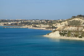
[[File:Malta Delimara three.jpg|thumb|200px|right|Fort Delimara from Marsaxlokk Bay]] |
[[File:Malta Delimara three.jpg|thumb|200px|right|Fort Delimara from Marsaxlokk Bay]] |
||
The fort was built between 1876 and |
The fort was built between 1876 and 1878 by the [[British Empire|British]].<ref name="morana">{{cite book|last1=Morana|first1=Martin|title=Bejn Kliem u Storja|date=2011|publisher=Books Distributors Limited|location=[[Malta]]|isbn=978-99957-0137-6|url=https://sites.google.com/site/kliemustorja/home/titlu/introduzzjoni/dwar-l-awtur/a/b/c/c/d|archiveurl=https://web.archive.org/web/20161005162338/https://sites.google.com/site/kliemustorja/home/titlu/introduzzjoni/dwar-l-awtur/a/b/c/c/d|archivedate=5 October 2016|language=Maltese}}</ref> The main gate carries a date of 1881, but this is the date of completion of the gatehouse, not the commissioning of the fort. |
||
Fort Delimara was |
Fort Delimara was one of a ring of forts and batteries that protected [[Marsaxlokk]] harbour, along with [[Fort Tas-Silġ]] at the shoreward end of Delimara point, [[Fort San Lucian]] on ''Kbira point'' in the middle of Marsaxlokk bay, [[Fort Benghisa]] on ''Benghisa Point'', and the [[Pinto Battery|Pinto]] and [[Ferretti Battery|Ferreti]] batteries on the shores of Marsaxlokk Bay. |
||
The nearby 17th century [[Delimara Tower]] was demolished to clear Fort Delimara's line of fire.<ref>{{cite book|last1=Zammit|first1=Vincent|title=Il-Gran Mastri - Ġabra ta' Tagħrif dwar l-Istorja ta' Malta fi Żmienhom - L-Ewwel Volum 1530-1680|date=1992|language=Maltese|publisher=Valletta Publishing & Promotion Co. Ltd.|location=[[Valletta]]|page=236}}</ref> |
|||
On 29 March 1903, defective bombs, which were stored at Fort Delimara prior to being disposed of, accidentally detonated after children tampered with a bomb in an attempt to open it, killing four.<ref>{{cite news |last1=Attard |first1=Eddie |title=Tragic accidents in our history that claimed young lives |url=https://timesofmalta.com/articles/view/tragic-accidents-in-our-history-that-claimed-young-lives.706709 |accessdate=2 February 2020 |work=[[Times of Malta]] |date=7 April 2019}}</ref> |
|||
In 1956 the fort was stripped of the majority of its [[artillery]]. Soon after, the fort was abandoned for a considerable period, and in 1975 it was leased by the Government of Malta to a local farmer, who used it to raise pigs from 1982 to 2005.<ref name=times2010-02-03/> |
In 1956 the fort was stripped of the majority of its [[artillery]]. Soon after, the fort was abandoned for a considerable period, and in 1975 it was leased by the Government of Malta to a local farmer, who used it to raise pigs from 1982 to 2005.<ref name=times2010-02-03/> |
||
After protracted negotiations, ownership of Fort Delimara was transferred to [[Heritage Malta]] on 11 August 2005. Despite the pigs and a considerable amount of modern debris, the fort still retains four of its original complement of fourteen [[Victorian era|Victorian]] [[RML 12.5 inch 38 ton gun|12.5-inch 38 ton rifled muzzle-loading guns]]. |
After protracted negotiations, ownership of Fort Delimara was transferred to [[Heritage Malta]] on 11 August 2005. The agency pays an annual rent of €764 to the government for the fort.<ref>{{cite news|last1=Debono|first1=James|title=Benghajsa fort to be returned to government|url=http://www.maltatoday.com.mt/news/national/14658/benghajsa-fort-to-be-returned-to-government|accessdate=31 December 2014|work=Malta Today|date=21 December 2011}}</ref> Despite the pigs and a considerable amount of modern debris,<ref name=times2010-02-03/> the fort still retains four<ref name="morana"/> of its original complement of fourteen [[Victorian era|Victorian]] [[RML 12.5 inch 38 ton gun|12.5-inch 38 ton rifled muzzle-loading guns]] mounted on dwarf carriages.<ref name=times2010-02-03/> |
||
The site is in a derelict condition and is under the responsibility of [[Heritage Malta]].<ref name="morana"/> There are plans to restore the fort and open it as a museum, but nothing materialized so far. It is currently not open to the public. |
|||
Heritage Malta intends to restore the site to its former condition, and open it to the public as a museum and tourist site, but it lacks the funds to do so. |
|||
==Layout== |
|||
==Details of the fort== |
|||
Fort Delimara is mostly underground, with the fort's main [[armament]] mounted in [[casemates]] set in the cliffs on the shoreward face of Delimara Point. At the surface it is a [[polygonal fort]], [[ |
Fort Delimara is mostly underground, with the fort's main [[armament]] mounted in [[casemates]] set in the cliffs on the shoreward face of Delimara Point. At the surface it is a [[polygonal fort]], [[hexagonal]] in outline, with rock cut ditches on four sides, and the gently curving vertical cliff forming the [[wikt:convex|convex]] fifth and sixth sides.<ref>{{cite web|title=Delimara Gas and Power Combined Cycle Gas Turbine and Liquefied Natural Gas receiving, storage and re-gasification facilities - Environmental Impact Assessment - Appendix Two Volume One|url=http://www.mepa.org.mt/EIACMS/documents/Delimara/B02i_CCGT-LNG_DPS_EIS_App02i_ESRs_A4_Simplex.pdf|website=MEPA|publisher=ERSLI Consultants Ltd on behalf of Enemalta Corporation|archiveurl=https://web.archive.org/web/20150329025345/http://www.mepa.org.mt/EIACMS/documents/Delimara/B02i_CCGT-LNG_DPS_EIS_App02i_ESRs_A4_Simplex.pdf|archivedate=29 March 2015|pages=26–28|date=20 December 2013}}</ref> Ventilation apertures and access passageways are spread out across the face of the cliff, and even out onto the seaward face of Delimara Point. |
||
{{-}} |
|||
===Gatehouse=== |
===Gatehouse=== |
||
[[File:Malta Delimara four.jpg|thumb|200px|left|Gatehouse.]] |
[[File:Malta Delimara four.jpg|thumb|200px|left|Gatehouse.]] |
||
The ditches are edged with [[revetting]], with the upper [[counterscarp|scarp]] faced in earth and rubble. A stone [[parapet]] with [[rifle]] loops runs along the top of the north scarp. A square building above the gate may be a later addition from the early twentieth century, when the fort was used as a [[military base]] long after its surface fortifications were obsolete. A [[World War II]] |
The ditches are edged with [[revetting]], with the upper [[counterscarp|scarp]] faced in earth and rubble. A stone [[parapet]] with [[rifle]] loops runs along the top of the north scarp. A square building above the gate may be a later addition from the early twentieth century, when the fort was used as a [[military base]] long after its surface fortifications were obsolete. A [[World War II]]-era [[Pillbox (military)|pillbox]] has been erected inside the Victorian fortification, and shows above the fort's profile when viewed from the sea. |
||
The [[gatehouse]] faces toward the landward end of Delimara Point, reached by a tarmac road that runs outside the north ditch. The gatehouse is close to the seaward end of the north ditch. |
The [[gatehouse]] faces toward the landward end of Delimara Point, reached by a tarmac road that runs outside the north ditch. The gatehouse is close to the seaward end of the north ditch. |
||
{{-}} |
{{-}} |
||
| Line 84: | Line 51: | ||
===Counterscarp battery=== |
===Counterscarp battery=== |
||
[[File:Malta Delemara two.jpg|thumb|200px|left|Counterscarp battery, looking east down the north ditch.]] |
[[File:Malta Delemara two.jpg|thumb|200px|left|Counterscarp battery, looking east down the north ditch.]] |
||
A |
A counterscarp battery at the north end of the east ditch commands the north ditch and the gatehouse. Presumably there is a counterscarp battery at the south end of the east ditch covering the south ditch, since there are no caponiers visible in the ditch. |
||
{{-}} |
{{-}} |
||
| Line 99: | Line 66: | ||
== Present condition == |
== Present condition == |
||
[[File:Malta Delimara five.jpg|thumb|200px|left|The east ditch looking south.]] |
[[File:Malta Delimara five.jpg|thumb|200px|left|The east ditch looking south.]] |
||
Externally the fort is in fair condition. Like all the polygonal forts in Malta, the [[limestone]] faces of the scarp and counterscarp have eroded substantially since they were originally cut, in places to a depth of as much as a metre. In some cases this erosion has reached the point that the revetting collapses into the ditch. |
Externally the fort is in fair condition. Like all the polygonal forts in Malta, the [[limestone]] faces of the scarp and counterscarp have eroded substantially since they were originally cut, in places to a depth of as much as a metre. In some cases this erosion has reached the point that the revetting collapses into the ditch.<ref>{{cite news|last1=Carabott|first1=Sarah|title=Forts under attack from neglect and vandalism|url=http://www.timesofmalta.com/articles/view/20160829/local/watch-forts-under-attack-from-neglect-and-vandalism.623427|work=[[Times of Malta]]|date=29 August 2016|archiveurl=https://web.archive.org/web/20160830161318/http://www.timesofmalta.com/articles/view/20160829/local/watch-forts-under-attack-from-neglect-and-vandalism.623427|archivedate=30 August 2016}}</ref> |
||
Where the road to Delimara Lighthouse runs along the east ditch of the fort, directly above the counterscarp face of the ditch a section of perhaps ten metres the counterscarp has collapsed into the ditch, and threatens the stability of the road. The resulting rubble fall can be seen in the image of the east ditch. |
Where the road to [[Delimara Lighthouse]] runs along the east ditch of the fort, directly above the counterscarp face of the ditch a section of perhaps ten metres the counterscarp has collapsed into the ditch, and threatens the stability of the road. The resulting rubble fall can be seen in the image of the east ditch. |
||
The ditch is also considerably overgrown, and polluted with general rubbish, unfortunately true of all the Victorian forts in Malta. There is currently no public access to the interior of the fort. |
The ditch is also considerably overgrown, and polluted with general rubbish, unfortunately true of all the Victorian forts in Malta. There is currently no public access to the interior of the fort. |
||
The fort is in danger of collapse, mainly due to coastal erosion and wave action which were only made worse with the building of the Delimara Power Station and the breakwater of the [[Malta Freeport]] nearby.<ref>{{cite news|last1=Calleja|first1=Claudia|title=Fort Delimara may soon be history|url=http://www.timesofmalta.com/articles/view/20090809/local/fort-delimara-may-soon-be-history.268708|accessdate=23 December 2014|work=[[Times of Malta]]|date=9 August 2009}}</ref> No plans have been made for the restoration of the fort, mainly due to a lack of funds.<ref name=times2010-02-03>{{cite news|title=No plans yet to restore crumbling Fort Delimara|url=http://www.timesofmalta.com/articles/view/20100203/local/no-plans-yet-to-restore-crumbling-fort-delimara.292401|accessdate=23 December 2014|work=[[Times of Malta]]|date=3 February 2010}}</ref> [[Din l-Art Ħelwa]] said that restoration would cost millions of euros and take about 10 years.<ref>{{cite news|last1=Ameen|first1=Juan|title=NGO comes forward to save Fort Delimara|url=http://www.timesofmalta.com/articles/view/20100205/local/ngo-comes-forward-to-save-fort-delimara.292768|accessdate=23 December 2014|work=[[Times of Malta]]|date=5 February 2010}}</ref> |
The fort is in danger of collapse, mainly due to coastal erosion and wave action which were only made worse with the building of the Delimara Power Station and the breakwater of the [[Malta Freeport]] nearby.<ref>{{cite news|last1=Calleja|first1=Claudia|title=Fort Delimara may soon be history|url=http://www.timesofmalta.com/articles/view/20090809/local/fort-delimara-may-soon-be-history.268708|accessdate=23 December 2014|work=[[Times of Malta]]|date=9 August 2009}}</ref> Parts of the nearby cliff face have already collapsed.<ref>{{cite news|title=Cliff collapse in Delimara leaves Gudja man critically injured|url=http://www.timesofmalta.com/articles/view/20150809/local/cliff-collapse-in-delimara-leaves-gudja-man-critically-injured.580006|accessdate=9 August 2015|work=[[Times of Malta]]|date=9 August 2015}}</ref> No plans have been made for the restoration of the fort, mainly due to a lack of funds.<ref name=times2010-02-03>{{cite news|title=No plans yet to restore crumbling Fort Delimara|url=http://www.timesofmalta.com/articles/view/20100203/local/no-plans-yet-to-restore-crumbling-fort-delimara.292401|accessdate=23 December 2014|work=[[Times of Malta]]|date=3 February 2010}}</ref> [[Din l-Art Ħelwa]] said that restoration would cost millions of euros and take about 10 years.<ref>{{cite news|last1=Ameen|first1=Juan|title=NGO comes forward to save Fort Delimara|url=http://www.timesofmalta.com/articles/view/20100205/local/ngo-comes-forward-to-save-fort-delimara.292768|accessdate=23 December 2014|work=[[Times of Malta]]|date=5 February 2010}}</ref> |
||
In 2015, the fort was shortlisted as a possible site for the campus of the proposed [[American University of Malta]]. It was not chosen, and the campus is to be split up between Dock No. 1 in [[Cospicua]] and Żonqor Point in [[Marsaskala]].<ref>{{cite news|title='American' University to occupy Dock 1 buildings and reduced Zonqor site|url=http://www.timesofmalta.com/articles/view/20150820/local/update-3-american-university-to-occupy-dock-1-buildings-and-reduced.581335|accessdate=20 August 2015|work=[[Times of Malta]]|date=20 August 2015}}</ref> |
|||
== In popular culture == |
|||
*The fort was used in the filming of the 2016 film ''[[Assassin's Creed (film)|Assassin's Creed]]''.<ref>{{cite web|last1=Siegel|first1=Lucas|title=New Assassin's Creed Set Pictures, Shooting Information from Malta|url=http://comicbook.com/2015/11/04/new-assassins-creed-set-pictures-shooting-information-from-malta/|website=comicbook.com|archiveurl=https://web.archive.org/web/20151127200150/http://comicbook.com/2015/11/04/new-assassins-creed-set-pictures-shooting-information-from-malta/|archivedate=27 November 2015|date=4 November 2014}}</ref> |
|||
== Gallery == |
== Gallery == |
||
<gallery class="center" mode="packed" heights="120px"> |
|||
<gallery> |
|||
Malta Delimara eight.jpg|North casemates and the end of the north ditch |
|||
Malta Delimara nine.jpg|Centre sections of the battery |
|||
Malta Delimara seven.jpg|Centre sections of the battery |
|||
Malta Delimara ten.jpg|South casemates and the end of the south ditch |
|||
Malta - Marsaxlokk (Fort Delimara) 02 ies.jpg|View from the fort |
|||
</gallery> |
</gallery> |
||
==References== |
==References== |
||
{{Commons category}} |
|||
{{Commonscat|Fort Delimara}} |
|||
{{Reflist}} |
|||
{{Forts in Malta}} |
|||
[[Category:Polygonal forts in Malta]] |
[[Category:Polygonal forts in Malta|Delimara]] |
||
[[Category: |
[[Category:Buildings and structures completed in 1888]] |
||
[[Category:Marsaxlokk]] |
[[Category:Marsaxlokk]] |
||
[[Category:British fortifications in Malta|Delimara]] |
|||
[[Category:Limestone buildings in Malta]] |
|||
[[Category:Military installations closed in the 1950s]] |
|||
[[Category:19th-century fortifications]] |
|||
Latest revision as of 14:40, 8 March 2023
| Fort Delimara | |
|---|---|
Il-Fortizza ta' Delimara | |
| Marsaxlokk, Malta | |
 Casemates of Fort Delimara | |
| Coordinates | 35°49′26″N 14°33′27″E / 35.82389°N 14.55750°E |
| Type | Polygonal fort |
| Area | 24,000 m2 (260,000 sq ft)[1] |
| Site information | |
| Owner | Government of Malta |
| Controlled by | Heritage Malta |
| Open to the public | No |
| Condition | Intact but in danger of collapse |
| Site history | |
| Built | 1876–1888 |
| Built by | British Empire |
| In use | 1880s–1950s |
| Materials | Limestone and Concrete |
Fort Delimara (Maltese: Il-Fortizza ta' Delimara) is a polygonal fort in Marsaxlokk, Malta. It was built between 1876 and 1888 by the British as part of a chain of fortifications intended to protect Marsaxlokk Harbour. Today, the fort is still intact but is in need of restoration, and is in danger of collapse due to coastal erosion.
History[edit]

The fort was built between 1876 and 1878 by the British.[2] The main gate carries a date of 1881, but this is the date of completion of the gatehouse, not the commissioning of the fort.
Fort Delimara was one of a ring of forts and batteries that protected Marsaxlokk harbour, along with Fort Tas-Silġ at the shoreward end of Delimara point, Fort San Lucian on Kbira point in the middle of Marsaxlokk bay, Fort Benghisa on Benghisa Point, and the Pinto and Ferreti batteries on the shores of Marsaxlokk Bay.
The nearby 17th century Delimara Tower was demolished to clear Fort Delimara's line of fire.[3]
On 29 March 1903, defective bombs, which were stored at Fort Delimara prior to being disposed of, accidentally detonated after children tampered with a bomb in an attempt to open it, killing four.[4]
In 1956 the fort was stripped of the majority of its artillery. Soon after, the fort was abandoned for a considerable period, and in 1975 it was leased by the Government of Malta to a local farmer, who used it to raise pigs from 1982 to 2005.[5]
After protracted negotiations, ownership of Fort Delimara was transferred to Heritage Malta on 11 August 2005. The agency pays an annual rent of €764 to the government for the fort.[6] Despite the pigs and a considerable amount of modern debris,[5] the fort still retains four[2] of its original complement of fourteen Victorian 12.5-inch 38 ton rifled muzzle-loading guns mounted on dwarf carriages.[5]
The site is in a derelict condition and is under the responsibility of Heritage Malta.[2] There are plans to restore the fort and open it as a museum, but nothing materialized so far. It is currently not open to the public.
Layout[edit]
Fort Delimara is mostly underground, with the fort's main armament mounted in casemates set in the cliffs on the shoreward face of Delimara Point. At the surface it is a polygonal fort, hexagonal in outline, with rock cut ditches on four sides, and the gently curving vertical cliff forming the convex fifth and sixth sides.[7] Ventilation apertures and access passageways are spread out across the face of the cliff, and even out onto the seaward face of Delimara Point.
Gatehouse[edit]

The ditches are edged with revetting, with the upper scarp faced in earth and rubble. A stone parapet with rifle loops runs along the top of the north scarp. A square building above the gate may be a later addition from the early twentieth century, when the fort was used as a military base long after its surface fortifications were obsolete. A World War II-era pillbox has been erected inside the Victorian fortification, and shows above the fort's profile when viewed from the sea. The gatehouse faces toward the landward end of Delimara Point, reached by a tarmac road that runs outside the north ditch. The gatehouse is close to the seaward end of the north ditch.
Counterscarp battery[edit]

A counterscarp battery at the north end of the east ditch commands the north ditch and the gatehouse. Presumably there is a counterscarp battery at the south end of the east ditch covering the south ditch, since there are no caponiers visible in the ditch.
East and south ditches[edit]

The glacis in front of the gatehouse has probably been reduced at some time to make road access easier, and the rolling bridge that would originally have crossed the ditch has been replaced by a permanent bridge. The road to Delimara Lighthouse along the east ditch of the fort disrupts the glacis on this face as well. The glacis is more intact along the south ditch, giving a better impression of how the fort would have looked when originally built.
Seaward face and gun emplacements[edit]

The seaward face of the fort is dominated by the massive stone and concrete casemates that originally sheltered the fort's 12.5 inch rifled muzzle loading guns. The casemates are grouped in pairs close to the cliff top, capped by an earth and rubble slope, and follow the natural curve of the cliff face, giving them a combined field of fire that covers the majority of Marsaxlokk harbour.
Present condition[edit]

Externally the fort is in fair condition. Like all the polygonal forts in Malta, the limestone faces of the scarp and counterscarp have eroded substantially since they were originally cut, in places to a depth of as much as a metre. In some cases this erosion has reached the point that the revetting collapses into the ditch.[8]
Where the road to Delimara Lighthouse runs along the east ditch of the fort, directly above the counterscarp face of the ditch a section of perhaps ten metres the counterscarp has collapsed into the ditch, and threatens the stability of the road. The resulting rubble fall can be seen in the image of the east ditch.
The ditch is also considerably overgrown, and polluted with general rubbish, unfortunately true of all the Victorian forts in Malta. There is currently no public access to the interior of the fort.
The fort is in danger of collapse, mainly due to coastal erosion and wave action which were only made worse with the building of the Delimara Power Station and the breakwater of the Malta Freeport nearby.[9] Parts of the nearby cliff face have already collapsed.[10] No plans have been made for the restoration of the fort, mainly due to a lack of funds.[5] Din l-Art Ħelwa said that restoration would cost millions of euros and take about 10 years.[11]
In 2015, the fort was shortlisted as a possible site for the campus of the proposed American University of Malta. It was not chosen, and the campus is to be split up between Dock No. 1 in Cospicua and Żonqor Point in Marsaskala.[12]
In popular culture[edit]
- The fort was used in the filming of the 2016 film Assassin's Creed.[13]
Gallery[edit]
-
 North casemates and the end of the north ditch
 -
 Centre sections of the battery
 -
 Centre sections of the battery
 -
 South casemates and the end of the south ditch
 -
 View from the fort


_02_ies.jpg)
References[edit]
- ^ "The American University of Malta - Preliminary Alternative Sites Evaluation Report" (PDF). Office of the Prime Minister. August 2015. p. 11. Archived from the original (PDF) on 16 November 2015.
- ^ a b c Morana, Martin (2011). Bejn Kliem u Storja (in Maltese). Malta: Books Distributors Limited. ISBN 978-99957-0137-6. Archived from the original on 5 October 2016.
- ^ Zammit, Vincent (1992). Il-Gran Mastri - Ġabra ta' Tagħrif dwar l-Istorja ta' Malta fi Żmienhom - L-Ewwel Volum 1530-1680 (in Maltese). Valletta: Valletta Publishing & Promotion Co. Ltd. p. 236.
- ^ Attard, Eddie (7 April 2019). "Tragic accidents in our history that claimed young lives". Times of Malta. Retrieved 2 February 2020.
- ^ a b c d "No plans yet to restore crumbling Fort Delimara". Times of Malta. 3 February 2010. Retrieved 23 December 2014.
- ^ Debono, James (21 December 2011). "Benghajsa fort to be returned to government". Malta Today. Retrieved 31 December 2014.
- ^ "Delimara Gas and Power Combined Cycle Gas Turbine and Liquefied Natural Gas receiving, storage and re-gasification facilities - Environmental Impact Assessment - Appendix Two Volume One" (PDF). MEPA. ERSLI Consultants Ltd on behalf of Enemalta Corporation. 20 December 2013. pp. 26–28. Archived from the original (PDF) on 29 March 2015.
- ^ Carabott, Sarah (29 August 2016). "Forts under attack from neglect and vandalism". Times of Malta. Archived from the original on 30 August 2016.
- ^ Calleja, Claudia (9 August 2009). "Fort Delimara may soon be history". Times of Malta. Retrieved 23 December 2014.
- ^ "Cliff collapse in Delimara leaves Gudja man critically injured". Times of Malta. 9 August 2015. Retrieved 9 August 2015.
- ^ Ameen, Juan (5 February 2010). "NGO comes forward to save Fort Delimara". Times of Malta. Retrieved 23 December 2014.
- ^ "'American' University to occupy Dock 1 buildings and reduced Zonqor site". Times of Malta. 20 August 2015. Retrieved 20 August 2015.
- ^ Siegel, Lucas (4 November 2014). "New Assassin's Creed Set Pictures, Shooting Information from Malta". comicbook.com. Archived from the original on 27 November 2015.
| |