
Herbaijum: Difference between revisions
mNo edit summary |
remove flags per MOS:FLAGS |
||
| (13 intermediate revisions by 10 users not shown) | |||
| Line 1: | Line 1: | ||
{{use dmy dates|date=April 2022}} |
|||
{{Infobox settlement |
{{Infobox settlement |
||
| |
| name = Herbaijum |
||
| |
| native_name = Hjerbeam |
||
| native_name_lang = <!-- ISO 639-2 code e.g. "fr" for French. If more than one, use {{lang}} instead --> |
|||
|mapsize = 280px |
|||
| settlement_type = Village |
|||
|subdivision_type = Country |
|||
| image_skyline = Herbaijum, kerk foto2 2010-04-17 11.50.JPG |
|||
|subdivision_name = {{flagicon|Netherlands}} [[Netherlands]] |
|||
| image_alt = |
|||
|subdivision_type1 = Province |
|||
| image_caption = Herbaijum church |
|||
|subdivision_name1 = {{flagicon|Friesland}} [[Friesland]] |
|||
| image_flag = |
|||
|settlement_type = Village |
|||
| flag_alt = |
|||
|population_total = c. 250 |
|||
| image_seal = |
|||
| seal_alt = |
|||
| image_shield = |
|||
| shield_alt = |
|||
| etymology = |
|||
| nickname = |
|||
| motto = |
|||
| image_map = Map NL Frjentsjerteradiel Hjerbeam.png |
|||
| map_alt = |
|||
| map_caption = Location in the Franekeradeel municipality |
|||
| pushpin_map = Netherlands Friesland#Netherlands<!-- the name of a location map as per http://en.wikipedia.org/wiki/Template:Location_map --> |
|||
| pushpin_label_position = right |
|||
| pushpin_mapsize = 250 |
|||
| pushpin_map_caption = Location in the Netherlands |
|||
| coordinates = {{coord|53|11|7|N|5|29|42|E|display=title|region:NL_type:city_source:nlwiki}} |
|||
| coor_pinpoint = |
|||
| coordinates_footnotes = |
|||
| subdivision_type = Country |
|||
| subdivision_name = [[Netherlands]] |
|||
| subdivision_type1 = [[Provinces of the Netherlands|Province]] |
|||
| subdivision_name1 = [[Friesland]] |
|||
| subdivision_type2 = [[List of municipalities of the Netherlands|Municipality]] |
|||
| subdivision_name2 = [[Waadhoeke]] |
|||
| subdivision_type3 = |
|||
| subdivision_name3 = |
|||
| established_title = |
|||
| established_date = |
|||
| founder = |
|||
| seat_type = |
|||
| seat = |
|||
| government_footnotes = |
|||
| leader_party = |
|||
| leader_title = |
|||
| leader_name = |
|||
| unit_pref = Metric |
|||
<!-- ALL fields with measurements have automatic unit conversion --> |
|||
<!-- for references: use <ref> tags --> |
|||
| area_footnotes = <ref name="stat"/> |
|||
| area_total_km2 = 3.05 |
|||
| elevation_footnotes = <ref name="AHN">{{cite web |url = http://www.ahn.nl/postcodetool |title = Postcodetool for 8807PA |language = nl |work = Actueel Hoogtebestand Nederland |publisher = Het Waterschapshuis |access-date = 4 April 2022 }}</ref> |
|||
| elevation_m = 0.3 |
|||
| population_as_of = 2021 |
|||
| population_footnotes = <ref name="stat">{{cite web |url=https://www.cbs.nl/-/media/_excel/2021/48/kwb-2021.xls |title=Kerncijfers wijken en buurten 2021 |website=Central Bureau of Statistics |access-date=4 April 2022}}</ref> |
|||
| population_total = 260 |
|||
| population_density_km2 = auto |
|||
| population_note = |
|||
| population_demonym = |
|||
| timezone1 = |
|||
| utc_offset1 = |
|||
| timezone1_DST = |
|||
| utc_offset1_DST = |
|||
| timezone = [[Central European Time|CET]] |
|||
| utc_offset = +1 |
|||
| timezone_DST = [[Central European Summer Time|CEST]] |
|||
| utc_offset_DST = +2 |
|||
| postal_code_type = [[List of postal codes in the Netherlands|Postal code]] |
|||
| postal_code = 8807<ref name="stat"/> |
|||
| area_code_type = [[Telephone numbers in the Netherlands|Dialing code]] |
|||
| area_code = 0517 |
|||
| iso_code = |
|||
| footnotes = |
|||
}} |
}} |
||
'''Herbaijum''' ({{lang-fry|Hjerbeam}}) is a |
'''Herbaijum''' ({{lang-fry|Hjerbeam}}) is a village in [[Waadhoeke]] municipality in the province [[Friesland]] of the [[Netherlands]] and had around 253 citizens in January 2014.<ref>[https://www.franekeradeel.nl/wonen-en-werken/publicatie/aantal-inwoners-per-buurtdorp Aantal inwoners per buurt/dorp] {{Webarchive|url=https://web.archive.org/web/20120812122533/http://www.franekeradeel.nl/wonen-en-werken/publicatie/aantal-inwoners-per-buurtdorp |date=2012-08-12 }} - Franekeradeel</ref> Until 2018, the village was part of the [[Franekeradeel]] municipality.<ref name="plaats"/> |
||
__NOTOC__ |
|||
== History == |
== History == |
||
The village was first mentioned in the 13th century as Herbadingum, and means "settlement of the people of Herbad (person)".<ref>{{cite web|url=https://etymologiebank.nl/trefwoord/herbaijum |title=Herbaijum - (geografische naam) |website=Etymologiebank |access-date=4 April 2022 |language=nl}}</ref> Herbaijum is a small ''[[terp]]'' (artificial living hill) village.<ref name="wonder">{{cite web|url=https://www.frieslandwonderland.nl/plaats/herbaijum |title=Herbaijum |website=Friesland Wonderland |access-date=4 April 2022 |language=nl}}</ref> |
|||
{{expand-section|date=August 2012}} |
|||
===Church === |
|||
[[File:Herbaijum, kerk foto2 2010-04-17 11.50.JPG|Herbaijum, church|thumb|150px|left]] |
|||
The church was built in the [[Middle Ages]]; general estimates point to establishment around the second half of the 13th century. It was dedicated to a [[Nicolaas van Myra]]. |
|||
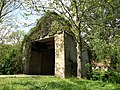
The ''[[stins]]'' Sikkema State was built in the 15th century or earlier. One of the inhabitants was [[Sicco van Goslinga]], ''[[grietman]]'' (mayor/judge) of [[Frankeradeel]] and curator of the [[University of Franeker]]. In the late-18th century, the estate was torn down and replaced by a farm, and only the gate remains.<ref>{{cite web|url=http://stinseninfriesland.nl/SikkemaState.htm |title=Sikkema State|website=Stinsen in Friesland|access-date=4 April 2022 |language=nl}}</ref><ref name="wonder"/> |
|||
A near complete restoration of the church, except for the north wall, was undertaken in 1872 under the guidance of architect P.J. Jaarsma. The north wall consists largely of yellow, mediaeval bricks—called ''kloostermoppen''—which were locally repaired. Any missing ones were replaced by similar small, yellow bricks made locally in Frisia. The tower on the west side was probably built in the 1920s, and has a constricted, [[octagon]]al [[spire]] and is roofed with [[slate]] tiles. |
|||
Herbaijum was home to 215 people in 1840.<ref name="plaats">{{cite web|url=https://www.plaatsengids.nl/herbaijum |title=Herbaijum |access-date=4 April 2022 |language=nl}}</ref> |
|||
==Church== |
|||
The church was built in the [[Middle Ages]]; general estimates point to establishment around the second half of the 13th century. It was dedicated to [[Saint Nicholas|Nicolaos van Myra]]. |
|||
A near complete restoration of the church, except for the north wall, was undertaken in 1872 under the guidance of architect P.J. Jaarsma.<ref name="wonder"/> The north wall consists largely of yellow, mediaeval bricks—called ''kloostermoppen''—which were locally repaired. Any missing ones were replaced by similar small, yellow bricks made locally in Frisia. The tower on the west side was probably built in the 1920s, and has a constricted, [[octagon]]al [[spire]] and is roofed with [[slate]] tiles. |
|||
According to a gable stone, the church was again restored in 1985. |
According to a gable stone, the church was again restored in 1985. |
||
== |
==Demographics== |
||
=== Population === |
=== Population === |
||
* 1954 - 278 |
* 1954 - 278 |
||
| Line 31: | Line 98: | ||
* 2003 - 294 |
* 2003 - 294 |
||
=== Notable people === |
|||
=== Famous (former) residents of Herbaijum === |
|||
* [[Sicco van Goslinga]], ( |
* [[Sicco van Goslinga]], (1664–1730) statesman<ref name="wonder"/> |
||
* [[Jopie Huisman]] (1922–2000), autodidactic painter and rag-and-bone man. Huisman ran a [[scrap metal]] company in Herbaijum and is buried in the village.<ref>{{cite web|url=https://www.jopiehuismanmuseum.nl/over-jopie/biografie |title=Biographie |website=Jopie Huisman museum |access-date=4 April 2022 |language=nl}}</ref> |
|||
== Gallery == |
|||
{{coord|53|11|7|N|5|29|42|E|display=title|region:NL_type:city_source:nlwiki}} |
|||
<gallery> |
|||
File:Achterkant Boerderijtje. Herbaijum.JPG|Farm in Herbaijum |
|||
File:Herbaijum, Sickema state poortgebouw RM15855 (2).jpg|Gate building of Sickema State |
|||
File:Graf Kunstschilder Jopie Huisman Herbaijum.JPG|Grave of [[Jopie Huisman]] |
|||
</gallery> |
|||
==References== |
|||
[[Category:Franekeradeel]] |
|||
{{Reflist}} |
|||
[[Category:Populated places in Friesland]] |
|||
==External links== |
|||
[[fr:Herbaijum]] |
|||
*{{commonscatinline}} |
|||
[[fy:Hjerbeam]] |
|||
[[nl:Herbaijum]] |
|||
{{Dutch municipality Waadhoeke}} |
|||
{{Authority control}} |
|||
[[Category:Waadhoeke]] |
|||
[[Category:Populated places in Friesland]] |
|||
Latest revision as of 19:57, 26 November 2023
Herbaijum
Hjerbeam | |
|---|---|
Village | |
 Herbaijum church | |
 Location in the Franekeradeel municipality | |
 Herbaijum Location in the Netherlands  Herbaijum Herbaijum (Netherlands) | |
| Coordinates: 53°11′7″N 5°29′42″E / 53.18528°N 5.49500°E | |
| Country | Netherlands |
| Province | Friesland |
| Municipality | Waadhoeke |
| Area | |
| • Total | 3.05 km2 (1.18 sq mi) |
| Elevation | 0.3 m (1.0 ft) |
| Population (2021)[1] | |
| • Total | 260 |
| • Density | 85/km2 (220/sq mi) |
| Postal code | 8807[1] |
| Dialing code | 0517 |
Herbaijum (West Frisian: Hjerbeam) is a village in Waadhoeke municipality in the province Friesland of the Netherlands and had around 253 citizens in January 2014.[3] Until 2018, the village was part of the Franekeradeel municipality.[4]
History[edit]
The village was first mentioned in the 13th century as Herbadingum, and means "settlement of the people of Herbad (person)".[5] Herbaijum is a small terp (artificial living hill) village.[6]
The stins Sikkema State was built in the 15th century or earlier. One of the inhabitants was Sicco van Goslinga, grietman (mayor/judge) of Frankeradeel and curator of the University of Franeker. In the late-18th century, the estate was torn down and replaced by a farm, and only the gate remains.[7][6]
Herbaijum was home to 215 people in 1840.[4]
Church[edit]
The church was built in the Middle Ages; general estimates point to establishment around the second half of the 13th century. It was dedicated to Nicolaos van Myra.
A near complete restoration of the church, except for the north wall, was undertaken in 1872 under the guidance of architect P.J. Jaarsma.[6] The north wall consists largely of yellow, mediaeval bricks—called kloostermoppen—which were locally repaired. Any missing ones were replaced by similar small, yellow bricks made locally in Frisia. The tower on the west side was probably built in the 1920s, and has a constricted, octagonal spire and is roofed with slate tiles.
According to a gable stone, the church was again restored in 1985.
Demographics[edit]
Population[edit]
- 1954 - 278
- 1959 - 273
- 1964 - 255
- 1969 - 290
- 1973 - 241
- 2003 - 294
Notable people[edit]
- Sicco van Goslinga, (1664–1730) statesman[6]
- Jopie Huisman (1922–2000), autodidactic painter and rag-and-bone man. Huisman ran a scrap metal company in Herbaijum and is buried in the village.[8]
Gallery[edit]
-
 Farm in Herbaijum
 -
 Gate building of Sickema State
 -
 Grave of Jopie Huisman

.jpg)

References[edit]
- ^ a b c "Kerncijfers wijken en buurten 2021". Central Bureau of Statistics. Retrieved 4 April 2022.
- ^ "Postcodetool for 8807PA". Actueel Hoogtebestand Nederland (in Dutch). Het Waterschapshuis. Retrieved 4 April 2022.
- ^ Aantal inwoners per buurt/dorp Archived 2012-08-12 at the Wayback Machine - Franekeradeel
- ^ a b "Herbaijum" (in Dutch). Retrieved 4 April 2022.
- ^ "Herbaijum - (geografische naam)". Etymologiebank (in Dutch). Retrieved 4 April 2022.
- ^ a b c d "Herbaijum". Friesland Wonderland (in Dutch). Retrieved 4 April 2022.
- ^ "Sikkema State". Stinsen in Friesland (in Dutch). Retrieved 4 April 2022.
- ^ "Biographie". Jopie Huisman museum (in Dutch). Retrieved 4 April 2022.
External links[edit]
 Media related to Herbaijum at Wikimedia Commons