Różyny: Difference between revisions
Content deleted Content added
m →top: unsourced/poorly sourced, removed: {{lang-de|, has a population |
m Merge coordinate templates (AWB) |
||
| Line 16: | Line 16: | ||
| subdivision_type3 = [[Gmina]] |
| subdivision_type3 = [[Gmina]] |
||
| subdivision_name3 = [[Gmina Pszczółki|Pszczółki]] |
| subdivision_name3 = [[Gmina Pszczółki|Pszczółki]] |
||
| coordinates = {{coord|54|12|13|N|18|39|53|E|region:PL|display=inline}} |
| coordinates = {{coord|54|12|13|N|18|39|53|E|region:PL|display=title,inline}} |
||
| pushpin_map = Poland#Poland Pomeranian Voivodeship |
| pushpin_map = Poland#Poland Pomeranian Voivodeship |
||
| pushpin_label_position = right |
| pushpin_label_position = right |
||
| Line 38: | Line 38: | ||
{{Gmina Pszczółki}} |
{{Gmina Pszczółki}} |
||
{{coord|54|12|13|N|18|39|53|E|region:PL_type:city|display=title}} |
|||
{{DEFAULTSORT:Rozyny}} |
{{DEFAULTSORT:Rozyny}} |
||
Revision as of 01:49, 30 September 2023
Różyny | |
|---|---|
Village | |
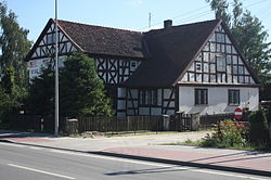
 Mennonite house in Różyny | |
| Coordinates: 54°12′13″N 18°39′53″E / 54.20361°N 18.66472°E | |
| Country | |
| Voivodeship | Pomeranian |
| County | Gdańsk |
| Gmina | Pszczółki |
| Population | 1,103 (2,011)[1] |
| Time zone | UTC+1 (CET) |
| • Summer (DST) | UTC+2 (CEST) |
| Website | http://rozyny.pl |
Różyny [ruˈʐɨnɨ] is a village in the administrative district of Gmina Pszczółki, within Gdańsk County, Pomeranian Voivodeship, in northern Poland.[2] It lies approximately 5 kilometres (3 mi) north-west of Pszczółki, 8 km (5 mi) south of Pruszcz Gdański, and 19 km (12 mi) south of the regional capital Gdańsk. It is located within the historic region of Pomerania.
Różyny was a royal village of the Polish Crown, administratively located in the Tczew County in the Pomeranian Voivodeship.[3]
References
- ^ "Wieś Różyny (pomorskie) » mapy, GUS, nieruchomości, regon, kod pocztowy, atrakcje, wypadki drogowe, kierunkowy, edukacja, demografia, tabele, zabytki, statystyki, linie kolejowe, liczba ludności". Polska w liczbach (in Polish). Retrieved 2023-05-30.
- ^ "Central Statistical Office (GUS) - TERYT (National Register of Territorial Land Apportionment Journal)" (in Polish). 2008-06-01.
- ^ Marian Biskup, Andrzej Tomczak, Mapy województwa pomorskiego w drugiej połowie XVI w., Toruń, 1955, p. 113 (in Polish)
Wikimedia Commons has media related to Różyny.


