
Gmina Pszczółki
| Gmina Pszczółki | |||
|---|---|---|---|

|
|
||
| Basic data | |||
| State : | Poland | ||
| Voivodeship : | Pomerania | ||
| Powiat : | Gdański | ||
| Geographic location : | 54 ° 10 ' N , 18 ° 42' E | ||
| Residents : | see Gmina | ||
| Postal code : | 83-047 | ||
| Telephone code : | (+48) 58 | ||
| License plate : | GDA | ||
| Economy and Transport | |||
| Rail route : | Tczew – Danzig | ||
| Next international airport : | Danzig | ||
| Gmina | |||
| Gminatype: | Rural community | ||
| Gmina structure: | 9 school offices | ||
| Surface: | 49.84 km² | ||
| Residents: | 9683 (Jun. 30, 2019) |
||
| Population density : | 194 inhabitants / km² | ||
| Community number ( GUS ): | 2204062 | ||
| Administration (as of 2018) | |||
| Wójt : | Maciej Urbanek | ||
| Address: | ul.Pomorska 18 83-032 Pszczółki |
||
| Website : | www.pszczolki.pl | ||

The Gmina Pszczółki is a rural community in the powiat Gdański (Powiat Danzig) in the Polish Pomeranian Voivodeship . It has an area of 49.8 km², on which 9683 people live (June 30, 2019). Their seat is the village of the same name ( German Hohenstein , Kashubian Pszczółczi ).
geography
_location_map.png)

The rural community is located in Pomerania in the south of Powiat and the city of Gdansk . It borders the rural municipalities of Pruszcz Gdański , Gmina Suchy Dąb , Tczew and Trąbki Wielkie . 86 percent of the area is used for agriculture, forests make up only two percent.
history
With the First Partition of Poland , the municipality became part of the Kingdom of Prussia and the Dirschau district of the West Prussian province . In 1818 it came to the district of Danzig and in 1887 again to the district of Dirschau. Due to the provisions of the Versailles Treaty , the area fell to the Free City of Danzig after the First World War in 1920 and belonged to the Danziger Höhe district .
In the wake of World War II , West Prussia came to Poland . The local population was displaced.
From 1975 to 1998 the rural community was part of the Gdansk Voivodeship . Due to the proximity to the city of Gdansk, the population of the rural municipality has grown from 7694 inhabitants in 2004 to 9683.
Community structure
Schulzenämter
The rural community Pszczółki includes nine districts ( German names up to 1945 ), each with a Schulzenamt .
| Polish name | German name (until 1945) |
Pop. (2010) |
location | image |
|---|---|---|---|---|
| Kleszczewko | Klein Kleschkau | 311 | (Location) | |
| Kolnik | Kohling | 503 | (Location) |

|
| Ostrowite | Osterwick | 167 | (Location) | |
| Pszczółki | Hohenstein | 4053 | (Location) |

|
| Rębielcz | Rambeltsch | 904 | (Location) |

|
| Różyny | Rosenberg | 1083 | (Location) |

|
| Skowarcz | Fair warling | 1425 | (Location) |

|
| Ulkowy | Uhlkau | 331 | (Location) | |
| Żelisławki | Senslau | 536 | (Location) |
|
Other places to live are: Skowarcz-Kolonia, W Łąkach, Żelisław.
Attractions

Listed sights
- Windmill in Pszczółki, 19th century
- Arched house in Różyny, 18th century
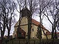
- Church in Różyny, 18th century
- Manor in Żelisławki, manor (1830), park, farmstead, granary (1898), distillery (1907), coach house (1912), house of the estate manager
Other sights in Pszczółki
- Catholic parish church
- Former Protestant Church (1931)
- Chapel on Tczewska Street
Museums
- Honey Museum in Skowarcz.

Windmill in Pszczółki

Front house in Różyny
Church in Różyny
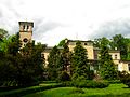
Manor house in Żelisławki


traffic

The rural community has very good transport links. The toll Autostrada A1 ( Europastraße 75 ) runs through the western part and Droga krajowa 91 (DK91) runs through the eastern part . Pszczółki station and the Różyny and Skowarcz stops are on the Warszawa – Gdańsk railway line .
Personalities
- Janusz Dyl (1954–2005, * in Pszczółki), Polish theologian
- Tadeusz Wojtas (* 1955 in Pszczółki), Polish cyclist.
Web links
Individual evidence
- ↑ population. Size and Structure by Territorial Division. As of June 30, 2019. Główny Urząd Statystyczny (GUS) (PDF files; 0.99 MiB), accessed December 24, 2019 .
- ↑ The Historical Place Directory
Municipality: Pruszcz Gdański (Praust) . Rural parishes : Cedry Wielkie (Groß Zünder) | Kolbudy (Ober Kahlbude) | Pruszcz Gdański (Praust) | Przywidz (Mariensee) | Pszczółki (Hohenstein) | Suchy Dąb (Zugdam) | Trąbki Wielkie (Great Hitchhiking) .