
Gmina Kolbudy
| Gmina Kolbudy | |||
|---|---|---|---|

|
|
||
| Basic data | |||
| State : | Poland | ||
| Voivodeship : | Pomerania | ||
| Powiat : | Gdańsk | ||
| Geographic location : | 54 ° 16 ′ N , 18 ° 28 ′ E | ||
| Residents : | see Gmina | ||
| Postal code : | 83-050 | ||
| Telephone code : | (+48) 58 | ||
| License plate : | GDA | ||
| Economy and Transport | |||
| Street : | DW 221 : Kościerzyna ↔ Danzig | ||
| Next international airport : | Danzig | ||
| Gmina | |||
| Gminatype: | Rural community | ||
| Gmina structure: | 18 villages | ||
| 15 school offices | |||
| Surface: | 82.80 km² | ||
| Residents: | 17,688 (Jun. 30, 2019) |
||
| Population density : | 214 inhabitants / km² | ||
| Community number ( GUS ): | 2204032 | ||
| Administration (as of 2015) | |||
| Wójt : | Leszek Józef Grombala | ||
| Address: | ul. Staromłyńska 1 83-050 Kolbudy |
||
| Website : | www.kolbudy.pl | ||

The Gmina Kolbudy is a rural community in the powiat Gdański in the Polish Pomeranian Voivodeship . It has an area of 82.8 km², on which 17,688 people live (June 30, 2019). Their seat is the village of the same name ( German Ober Kahlbude , Kashubian Kôlbùdë ).
geography
_location_map.png)
The rural community is located in Pomerania on the Danziger Höhe . The municipality borders with the town of Kowale directly on the city of Gdansk . The area belongs to the Kashubian Switzerland and is rich in lakes and watercourses. The hydropower plants on the small river Radunia (Radaune) supplied electricity to the city and the companies in Gdansk as early as the end of the 19th century. 34 percent of the area is forested.
history
With the First Partition of Poland , the municipality became part of the Kingdom of Prussia and the Province of West Prussia in 1772 . From 1818 to 1920 the area belonged to the Karthaus district . Due to the provisions of the Versailles Treaty , the area with the district of Danziger Höhe fell to the Free City of Danzig after the First World War in 1920 .
In the wake of World War II , West Prussia came to Poland . The local population was displaced .
From 1975 to 1998 the rural community was part of the Gdansk Voivodeship . In 1998 the parish seat of Kolbudy Górne was renamed Kolbudy (Górne corresponds to the former superior ). Due to the good transport connections, the village of Kowale developed into a settlement with a suburban character.
Community partnerships
There are community partnerships with Nemenčinės seniūnija in Lithuania , and the cities of Jaworiw in Ukraine and Uffenheim in Germany.
Community structure
Schulzenämter
The rural community Kolbudy includes fifteen districts, each with a Schulzenamt .
| Polish name | German name (until 1945) |
Pop. (2006) |
location | image |
|---|---|---|---|---|
| Babidół | Babenthal brickworks | 115 | (Location) | |
| Bąkowo | Bankau | 260 | (Location) |

|
| Bielkowo | Groß Bölkau | 252 | (Location) |

|
| Bielkówko | Klein Bölkau | 1392 | (Location) |
.JPG)
|
| Buszkowy | Upper Buschkau | 620 | (Location) | |
| Czapielsk | Czapielken | 838 | (Location) |

|
| Jankowo Gdańskie | Jenkau | 2137 | (Location) |

|
| Kolbudy | Upper Kahlbude | 3621 | (Location) |

|
| Kowale | Kowall | 5719 | (Location) |
_ulica_Aresa.JPG)
|
| Łapino | Lappin | 635 | (Location) |

|
| Lisewiec | Lissau | 218 | (Location) | |
| Lublewo Gdańskie | Löblau | 1512 | (Location) |
|
| Ostróżki | Ostroschken | 106 | (Location) | |
| Otomin | Ottomin | 726 | (Location) |
.jpg)
|
| Pręgowo | Prangenau | -? - | (Location) |

|
Other localities

The rural community includes three other localities without a Schulzenamt.
- Gołąbkowo (Golmkau via Praust)
- Krymki ( Krönke , 1939–1945 Krönken )
- Nowiny (novelty) .
The Schlangenberg residential area belonged to Klein Bölkau - Żmijewo still belongs to Bielkówko, but no longer has any residents.
Listed sights
In addition to the three old churches, the modern parish churches of Kolbudy and Kowale are also worth seeing.
- Church in Czapielsk, 18th century
- Church in Lublewo Gdańskie, 14th century and 1683
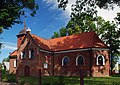
- Parish church in Pręgowo, 14th and 18th centuries
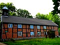
- Well in Bielkowo, park, fence and gate - ruins of the Vorwerk, 18th and 19th centuries
Church in Czapielsk
Church in Lublewo Gdańskie

Church in Pręgowo

Vorwerk in Bielkowo


traffic
The S6 expressway connects Kowale in the east of the rural municipality to Gdansk and Gdynia .
From 1886 to 1994 (passenger traffic) and until 2002 (freight traffic) there was a connection to a railway line from Pruszcz Gdański via Kartuzy and Lębork to Łeba . The operation was stopped for economic reasons.
Personalities
- Krzysztof Arciszewski (1592–1656), Vice-Governor and Admiral of the Dutch Brazil, became the owner of the village of Buschkau in 1648
- Karl-Heinz Bartsch (1923–2003, * in Löblau), Deputy Minister for Agriculture (GDR), briefly member of the Central Committee of the SED and candidate for the Politburo
- Liselotte Eder (1922–1993, * in Kowall), translator and actress, mother of Rainer Werner Fassbinder
- Erich Gust (1909–1992, * in Klein Bölkau), camp leader in Buchenwald concentration camp and in Stutthof
- August Malotki von Trzebiatowski (1808–1873, * in Klein Bölkau), Prussian lieutenant general.
Web links
Footnotes
- ↑ population. Size and Structure by Territorial Division. As of June 30, 2019. Główny Urząd Statystyczny (GUS) (PDF files; 0.99 MiB), accessed December 24, 2019 .
- ^ Website of the municipality, wójt , accessed on March 5, 2015
- ↑ The Historical Place Directory
- ↑ 1939–1945 Bölkau
- ↑ Formerly Neuheide
Municipality: Pruszcz Gdański (Praust) . Rural parishes : Cedry Wielkie (Groß Zünder) | Kolbudy (Ober Kahlbude) | Pruszcz Gdański (Praust) | Przywidz (Mariensee) | Pszczółki (Hohenstein) | Suchy Dąb (Zugdam) | Trąbki Wielkie (Great Hitchhiking) .