Fugging, Upper Austria: Difference between revisions
m added apostrophe |
m sr |
||
| Line 48: | Line 48: | ||
[[sk:Fucking]] |
[[sk:Fucking]] |
||
[[sl:Fucking]] |
[[sl:Fucking]] |
||
[[sr:Фукинг (Аустрија)]] |
|||
[[fi:Fucking]] |
[[fi:Fucking]] |
||
[[sv:Fucking]] |
[[sv:Fucking]] |
||
Revision as of 06:17, 11 November 2007

Fucking (IPA: [ˈfʊkɪŋ]; rhymes with "looking") is an Austrian village in the municipality of Tarsdorf[2], in the Innviertel region of western Upper Austria.[3] It is located 32 km north of Salzburg and 4 km east of the border with Germany, half an hour's ride from Petting in Bavaria. The village is known to have existed as "Fucking" since at least 1070 and is named after a man from the 6th century called Focko. "Ing" is an old Germanic suffix indicating the people of the root word to which it is attached (cf Beowulf's "Scylding" - people of Scyld); thus "Fucking," in this case, means “(place of )Focko’s people."[4] The village has a population of 93.
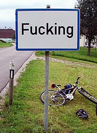
Fucking's most famous feature is a traffic sign with its name on it, beside which English-speaking tourists often stop to have their photograph taken. It is a commonly stolen street sign.[5] Significant amounts of public funds are spent on replacing the stolen signs.
In 2004, due to the stolen signs and embarrassment over the name, a vote was held on changing the village's name, but the residents voted against doing so.[4] In August 2005 the road signs were replaced with theft-resistant signs welded to steel and secured in concrete to prevent further chances of the sign being stolen.[6]
See also
- Place names with English meanings
- Place names considered unusual
- Effingham, Illinois
- Fjuckby, Sweden
- Phuket Province
