Shelby County, Kentucky: Difference between revisions
+p by census |
mNo edit summary |
||
| Line 30: | Line 30: | ||
==Demographics== |
==Demographics== |
||
{| border="1" cellspacing="0" cellpadding="5" style="float:right; margin-left:15px;" |
{| border="1" cellspacing="0" cellpadding="5" style="float:right; margin-left:15px;" |
||
|align=center colspan=2| ''' |
|align=center colspan=2| '''Shelby County<br />Population by year<br /> |
||
|- |
|- |
||
| align=center | |
| align=center | |
||
Revision as of 16:02, 20 June 2006
Shelby County | |
|---|---|
 Location within the U.S. state of Kentucky | |
 Kentucky's location within the U.S. | |
| Coordinates: 38°13′N 85°11′W / 38.22°N 85.19°W | |
| Country | |
| State | |
| Seat | Shelbyville |
| Population (2000) | |
| • Total | 33,337 |
| Website | www |
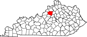
Shelby County is a county located in the U.S. state of Kentucky. As of 2000, the population was 33,337. Its name is in honor of Isaac Shelby, the first Governor of Kentucky. Its county seat is Shelbyville. Shelby County is a prohibition or completely dry county.6.
Geography
According to the U.S. Census Bureau, the county has a total area of 999 km² (386 mi²). 995 km² (384 mi²) of it is land and 4 km² (1 mi²) of it (0.38%) is water. Jeptha Knob in Shelby County is the highest point in the Louisville area.
Adjacent counties
- Henry County (north)
- Franklin County (east)
- Anderson County (southeast)
- Spencer County (southwest)
- Jefferson County (west)
- Oldham County (northwest)
Demographics
| Shelby County Population by year | |
|
2000 33,337 | |
As of the census² of 2000, there were 33,337 people, 12,104 households, and 9,126 families residing in the county. The population density was 34/km² (87/mi²). There were 12,857 housing units at an average density of 13/km² (34/mi²). The racial makeup of the county was 86.61% White, 8.83% Black or African American, 0.30% Native American, 0.40% Asian, 0.12% Pacific Islander, 2.39% from other races, and 1.34% from two or more races. 4.51% of the population were Hispanic or Latino of any race.
There were 12,104 households out of which 34.70% had children under the age of 18 living with them, 61.00% were married couples living together, 10.60% had a female householder with no husband present, and 24.60% were non-families. 20.20% of all households were made up of individuals and 8.00% had someone living alone who was 65 years of age or older. The average household size was 2.63 and the average family size was 3.00.
In the county the population was spread out with 25.20% under the age of 18, 8.70% from 18 to 24, 31.40% from 25 to 44, 24.00% from 45 to 64, and 10.80% who were 65 years of age or older. The median age was 36 years. For every 100 females there were 94.90 males. For every 100 females age 18 and over, there were 91.30 males.
The median income for a household in the county was $45,534, and the median income for a family was $52,764. Males had a median income of $35,484 versus $25,492 for females. The per capita income for the county was $20,195. About 6.50% of families and 9.90% of the population were below the poverty line, including 11.70% of those under age 18 and 12.30% of those age 65 or over.
