
Isa Lake: Difference between revisions
m copyedit, refine cat, and AWB general fixes using AWB |
Per WP:NOTUSA |
||
| Line 5: | Line 5: | ||
|image_bathymetry = |
|image_bathymetry = |
||
|caption_bathymetry = |
|caption_bathymetry = |
||
|location = [[Yellowstone National Park]], [[Teton County, Wyoming|Teton County]], [[Wyoming|Wyoming, |
|location = [[Yellowstone National Park]], [[Teton County, Wyoming|Teton County]], [[Wyoming|Wyoming, US]] |
||
|coords = {{coord|44|26|27|N|110|43|09|W|type:waterbody_region:US-WY|display=inline,title}}<ref name=gnis>{{cite gnis|id=1589979|name=Isa Lake}}</ref> |
|coords = {{coord|44|26|27|N|110|43|09|W|type:waterbody_region:US-WY|display=inline,title}}<ref name=gnis>{{cite gnis|id=1589979|name=Isa Lake}}</ref> |
||
|type = Natural lake |
|type = Natural lake |
||
Revision as of 23:15, 17 June 2014
| Isa Lake | |
|---|---|
| Location | Yellowstone National Park, Teton County, Wyoming, US |
| Coordinates | 44°26′27″N 110°43′09″W / 44.44083°N 110.71917°W[1] |
| Type | Natural lake |
| Basin countries | United States |
| Surface elevation | 8,297 feet (2,529 m)[1] |
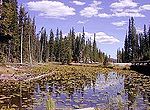
Isa Lake is located in Yellowstone National Park, in the U.S. state of Wyoming.[2] The lake straddles the continental divide at Craig Pass and was first discovered in 1891 by Hiram M. Chittenden, who was exploring the best routes for a road to connect Old Faithful and West Thumb geyser basins. Chittenden named the lake after Isabel Jelke, a woman from Cincinnati, though it is not clear why.[3]

Isa Lake is believed to be the only natural lake in the world which drains to two different oceans backwards.[3] (The man-made Gatun Lake in Panama also drains backwards into the Atlantic and Pacific Oceans via the Panama Canal.) The east side of the lake drains by way of the Lewis River to the Pacific Ocean and the west side of the lake drains by way of the Firehole River to the Atlantic Ocean.[4] This is the opposite of what one would expect since the Atlantic Ocean is east of the lake and the Pacific Ocean is to the west.
The lake is easy to visit as it is adjacent to the road that now connects the Old Faithful and West Thumb geysers basins, on what is known as the "lower loop" of the figure-eight roadway which traverses through Yellowstone.
-
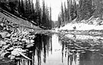 Isa Lake, 1921
 -
 Isa Lake on Craig Pass Road
 -
 Isa Lake


Notes
- ^ a b "Isa Lake". Geographic Names Information System. United States Geological Survey, United States Department of the Interior.
- ^ "Craig Pass, USGS Craig Pass (WY) Topo Map" (Map). TopoQuest USGS Quads. Retrieved 2008-06-29.
- ^ a b "Isa Lake". Grant Area Natural Highlights. National Park Service. Retrieved 2012-08-04.
{{cite web}}: Cite has empty unknown parameter:|coauthors=(help) - ^ "Isa Lake". Wyomingtourism.org. Retrieved 2012-08-04.
{{cite web}}: Cite has empty unknown parameter:|coauthors=(help)
Yellowstone National Park - Upper Geyser Basin | ||
|---|---|---|
Geothermal features and other attractions in the Upper Geyser Basin | ||
| Geysers |
|  |
| Hot springs | ||
| Structures and history | ||
| Geography | ||
| ||
This article about a location in Wyoming is a stub. You can help Wikipedia by expanding it. |