
Grand Teton National Park
| Grand Teton National Park | |||
|---|---|---|---|
 |
|||
|
|||
| Location: | Wyoming , United States | ||
| Next city: | Jackson (Wyoming) | ||
| Surface: | 1,254.71 km² | ||
| Founding: | February 26 , 1929 | ||
| Visitors: | 3,491,151 (2018) | ||
| Address: | Grand Teton National Park | ||
 |
|||
 |
|||
_location_map.svg)
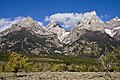
The Grand Teton National Park is located in western Wyoming south of Yellowstone National Park . It takes its name from the Teton chain , which runs north-south through the park. To the east of the mountains lies the wide plain called Jackson Hole and the large mountain lake Jackson Lake , as well as the smaller lakes Leigh Lake and Jenny Lake .
The region has been inhabited for at least 11,000 years when nomadic Paleo-Indians began to spend the warmer summer months there. John Colter was the first white man to see this area around 1808. The name of the mountains comes from the French word for breast and refers to their shape. The area was declared a national park on February 26, 1929 .
Geography and geology
The rugged profile of the Teton mountain range rises two thousand meters from the plain without a promontory. The highest point, the Grand Teton , is 4,198 meters above sea level.
Plate tectonics was the cause of the mountain formation . In the course of the formation of the Basin and Range Province , the expansion tectonics also affected today's Teton region. At a point in time dated between 13 and 9 million years ago, due to the expansion of the rock, a fault developed in a north-south direction on the eastern flank of today's mountains. This was followed by a deportation in which the block sank on the east side, creating the Jackson Hole Plain. The western block was pushed up at the fault during this movement, so that the Tetons have a steep east and a gentle west flank.
In the past 300,000 years during the Ice Age , glaciers have severely reshaped the landscape. Starting from the Absaroka Range east of Yellowstone National Park, a large plateau glacier emerged at least three times , which covered almost the entire area of both national parks. The Tetons were completely glaciated except for the highest peaks. A large tongue of glacier extended south from the Yellowstone area. The penultimate ice age , known in the region as the Bull Lake Stage , reached its greatest extent. It left terminal moraines in Jackson Hole. All glacial deposits south of Jackson Lake are from this era. In the last Ice Age , known as Wisconsin glaciation in North America and Pinedale stage in the Rocky Mountains , the glacier tongue did not reach quite that far. It ended with the tongue pool , in which Jackson Lake was formed as the tongue pool. Their terminal moraine at the southern end of the lake caused the Snake River to look for a new drain in the southeast after the glaciers had melted. Smaller glaciers emerged from the Tetons and carved out the trough valleys on the eastern flank. Their terminal moraines back up the smaller lakes below the mountains, such as Jenny Lake. The Jackson Hole plain is covered with glacial gravel, in which there are a multitude of small dead ponds .
At the foot of the mountains there are wide meadows with smaller, partially wooded hills and several lakes that are fed by natural tributaries from the mountains. The largest lake , Jackson Lake , was artificially enlarged by a dam before the national park was established.
In the deeper cuts below the meadows, the water collects in streams. The river named Snake River leaves the highlands through a narrow valley in the south.
South of the national park, near the village of Jackson , is the National Elk Refuge . Elk deer migrate to this retreat in winter to escape the cold of the higher regions.
natural reserve
Wolves have returned to the national park since 1999 as a result of the reintroduction to Yellowstone in 95/96. At the end of 2013, at least 53 animals lived in 7 packs within the boundaries of the park; eleven cubs survived from this year alone.
All pronghorns and most of the mule deer in the national park and the surrounding mountain ranges migrate south over the Gros Ventre Range to the valley on the upper reaches of the Green River in winter . With up to 260 km, these are the most widely known migratory movements of the two species. The winter quarters there is threatened by a boom in the use of natural gas deposits that began at the turn of the millennium . In addition, there are the designation of building areas and new road developments. The development endangered the existence of the two animal species in the national park. In 2003, the Bureau of Land Management mistakenly issued two drilling licenses in a section of the valley known as the bottleneck of hiking trails through which almost all pronghorns and many mule deer have to pull. The award was withdrawn after protests. At the beginning of 2010, the nature conservation organization "The Conservation Fund" concluded an agreement with landowners according to which the critical section of the hiking route will be permanently secured.

Bison in front of the Teton mountain range

Puma in Grand Teton National Park

Bison

Mugwort
Landscape in Garnet Canyon

Cow elk near Leigh Lake


history
The area was used by several Indian peoples as a hunting and living space. The Blackfoot and Crow were the leading Indian peoples at the time of first contact with whites. They were fur hunters and traders who first reached the region in the 1820s. At the end of the 19th century, several ranchers settled in Jackson Hole under the Homestead Act . Most of them belonged to the Church of Jesus Christ of Latter-day Saints ( Mormons ), which is why part of the valley floor with the farm buildings, stables and barns is called Mormon Row . A total of 479 sites of archaeological or historical interest have been identified in the park from the Indian and early historical periods. Two of them are designated as National Historic Landmarks : Murie Ranch , an important site for the creation of conservation in the region, and Jackson Lake Lodge as the first building of architectural modernism in connection with the Mission 66 program of the National Park Service. Jackson Lake Lodge is also known as the location of the Central Banks Economic Policy Symposium every August.
As early as the 19th century, the US federal government designated large forests in the vicinity of what is now the park as Teton Forest Reserve , thereby preventing settlement and uncontrolled clearing. The Teton Reserve was merged with the Yellowstone Forest Reserve to form the Yellowstone National Forest , from which the Teton National Forest was separated in 1908 , which included most of the Teton Range and its thickly forested, gentle western flank. Initial plans for a more extensive protected area and its expansion into the plain were rejected by most of the valley's residents and the landowners out of fundamental skepticism about nature conservation. John D. Rockefeller, Jr. and his family bought a former ranch on one of the small lakes as a holiday home in 1927, he supported the protection status and bought pastureland and abandoned ranches in the valley on a large scale through the front company Snake River Land Company disguised as a ranch operation .
The national park was designated in 1929, limited to the mountain range and a few small lakes directly below. In 1930 it became known that Rockefeller was behind the land purchases and that he bought the land for protection. The residents reacted with turmoil and anger that an outsider was using his enormous fortune to plan their home for nature conservation over their heads. The further purchase stalled and the politicians of the state of Wyoming spoke out against any nature conservation. When Rockefeller feared in 1942 that his efforts would have been in vain, he considered selling the space again. The National Park Service therefore convinced President Franklin D. Roosevelt to use his authority under the Antiquities Act of 1906 and unilaterally, without the participation of Congress, designate the land purchased by Rockefeller as a national monument . This happened in 1943; Roosevelt founded the Jackson Hole National Monument . Due to the industrialization of agriculture, after the end of World War II, the yields of extensive pasture farming in remote Jackson Hole fell behind compared to the intensively farmed regions further east. More and more landowners were no longer hostile to the idea of nature conservation, especially as tourism slowly became a source of income. Therefore, in 1950, Congress agreed to unite the National Monument with Grand Teton National Park.
From the time it was used by ranchers, there are still two active businesses in so-called inholdings , private properties that are completely enclosed by the park. The state of Wyoming has another inholding that is leased as pasture and a ranch outside and a living history business are allowed to graze on areas in the park. Together these areas make up about 2000 ha. The inholdings are problematic because they are not subject to the park's protection statute . In 2014, a wolf believed to have threatened grazing cattle was shot on one of the private properties. Investigations have not found any violation of Wyoming hunting rights.
activities
There are around 300 km of hiking trails in the park . The mountains are a paradise for mountaineers . Rafting is possible on the Snake River. The National Park Service offers educational activities.
In winter there are opportunities for cross-country skiing and trips with the sled dog .
Most visitors use Grand Teton National Park as a transit station on the John D Rockefeller, Jr. Memorial Parkway to Yellowstone National Park.
Some companies also offer rides on mules or sure-footed mountain horses down into the valley.
Web links
- National Park Service: Grand Teton National Park (official site; English)
- US National Parks Net: Grand Teton National Park (English)
Individual evidence
- ^ Robert B. Smith, Lee J. Siegel: Windows into the Earth - The Geologic Story of Yellowstone and Grand Teton National Parks . Oxford University Press, 2000, ISBN 0-19-510596-6 , p. 102 f.
- ^ Robert B. Smith, Lee J. Siegel: Windows into the Earth - The Geologic Story of Yellowstone and Grand Teton National Parks . Oxford University Press, 2000, ISBN 0-19-510596-6 , pages 111-131
- ↑ a b c National Park Service: Grand Teton National Park - Vital Signs 2013
- ↑ Hall Sawyer, Fred Lindzey, Doug McWhirter: Mule Deer and Pronghorn migration in Western Wyoming. In: Wildlife Society Bulletin , Vol. 33, No. 4 (Winter, 2005), ISSN 0091-7648 , pp. 1266-1273
- ↑ Jackson Hole News & Guide: Energy boom gives wildlife little room ( Memento of the original from August 10, 2004 in the Internet Archive ) Info: The archive link was automatically inserted and not yet checked. Please check the original and archive link according to the instructions and then remove this notice. , November 26, 2003
- ↑ Casper Star Tribune: BLM withdraws Trapper's Point leases ( Memento of November 18, 2008 in the Internet Archive ) (PDF file; 67 kB), August 15, 2003
- ↑ The Conservation Fund: The Conservation Fund Protects Funnel Bottleneck on the Path of the Pronghorn ( page no longer available , search in web archives ) Info: The link was automatically marked as defective. Please check the link according to the instructions and then remove this notice. , February 1, 2010
- ^ Jackson Hole History: Snake River Land Company
- ^ High Country News: Who should manage Grand Teton's private inholdings? , April 2, 2015


Acadia | American Samoa | Arches | Badlands | Big Bend | Biscayne | Black Canyon of the Gunnison | Bryce Canyon | Canyonlands | Capitol Reef | Carlsbad Caverns | Channel Islands | Congaree | Crater Lake | Cuyahoga Valley | Death Valley | Denali | Dry Tortugas | Everglades | Gates of the Arctic | Gateway Arch | Glacier | Glacier Bay | Grand Canyon | Grand Tetons | Great Basin | Great Sand Dunes | Great Smoky Mountains | Guadalupe Mountains | Haleakalā | Hawaii Volcanoes | Hot Springs | Indiana Dunes | Isle Royale | Joshua Tree | Katmai | Kenai Fjords | Kings Canyon | Kobuk Valley | Lake Clark | Let Volcanic | Mammoth Cave | Mesa Verde | Mount Rainier | North Cascades | Olympic | Petrified Forest | Pinnacles | Redwood | Rocky Mountain | Saguaro | Sequoia | Shenandoah | Theodore Roosevelt | Virgin Islands | Voyageurs | Wind Cave | White Sands | Wrangell-St. Elias | Yellowstone | Yosemite | Zion