Green River
| Green River | ||
|
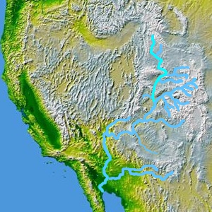
Course of the Green River ( turquoise ) |
||
| Data | ||
| Water code | US : 1428399 | |
| location | Wyoming , Colorado , Utah (USA) | |
| River system | Colorado River | |
| Drain over | Colorado River → Pacific Ocean | |
| source |
Wind River Range 43 ° 9 ′ 13 ″ N , 109 ° 40 ′ 18 ″ W. |
|
| muzzle | in Canyonlands National Park in the Colorado River Coordinates: 38 ° 11 ′ 21 " N , 109 ° 53 ′ 7" W 38 ° 11 ′ 21 " N , 109 ° 53 ′ 7" W |
|
| Mouth height |
1181 m
|
|
| length | 1175 km | |
| Catchment area | 124,578 km² | |
| Drain |
MQ |
173 m³ / s |
| Left tributaries | New Fork River , Big Sandy River , Yampa River , White River , Range Creek | |
| Reservoirs flowed through | Flaming Gorge Reservoir | |
| Small towns | Green River, WY | |
|
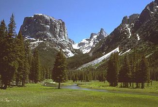
Green River in Wyoming |
||
|
Green River, Utah |
||
The Green River ( English for "Green River") is the largest tributary of the Colorado River in the western United States . It has its source in Wyoming , flows through Utah , makes a short loop through the US state of Colorado and flows into the Colorado River after 1,175 kilometers in Canyonlands National Park . There are several spectacular canyons on his way .
The Green River rises from the Wind River Range in the Rocky Mountains and flows south in western Wyoming and merges with the Big Sandy River . South of the city of Green River, WY is the Flaming Gorge Reservoir , which extends to the northeast corner of Utah. The reservoir is an important source of water in the region and is used to generate energy. The construction of the dam, completed in 1963, was controversial.
East of the Uinta Mountains , the Green River loops through northwest Colorado and comes back to Utah at Dinosaur National Monument , where the White River joins the river. Further south, the Green River first traverses Desolation Canyon and then Gray Canyon for a distance of 192 km before reaching the village of Green River, UT . It flows further south and meets the Colorado River in Canyonlands National Park.
history
Archaeological discoveries have shown that between the 7th and 13th centuries, people of the Fremont culture lived in the canyons of the Green River , who lived as semi- nomads in pit houses and left petroglyphs behind. In later centuries hunters of the Shoshone and Ute Indians settled in the valleys of the river.
The Spanish monks Dominguez and Escalante were the first whites to reach the river in 1776, which they called the Rio de San Buenaventura . When they later discovered the Sevier River further west , they mistakenly identified it with the Buenaventura and their cartographer Bernardo de Miera drew the river in a south-westerly direction instead of the correct course south to the Colorado River. This error gave rise to the decades-long search for the legendary Buenaventura River , which was to connect the Rocky Mountains with the Pacific Ocean . Spanish and Mexican explorers later renamed the real river to Colorado to Rio Verde (Spanish for Green River ), possibly because of the color of the water.
In 1819 British trappers from the Hudson's Bay Company came to the upper reaches of the Green River. In 1824, American fur hunters from the Rocky Mountain Fur Company headed by William Ashley and Jedediah Smith explored the river between the Uinta Mountains and the mouth of the White River . In 1825 the first so-called rendezvous of the fur hunters and traders took place on a tributary of the Green River. Fur traders later established several trading posts near the estuary. In the 1840s, John C. Frémont explored the region several times. He also noted that the Green River does not arise from the Great Salt Lake , as previously believed . John Wesley Powell mapped the river in 1869 and 1871, naming many of the canyons, rapids, and geographic features.
Vernal , the first permanent settlement on the Green River, was founded by Mormons in 1878 . The region was used for agriculture until the 1940s . Oil and natural gas were later discovered . Much of the land along the river is owned by the federal government. The tourism has become the main source of income in the region.
Ecosystems
The upper reaches of the Green River is part of the Greater Yellowstone Ecosystem . It is shaped by the mountain ranges of the Wind River Range and the Gros Ventre Range . The high valley is winter quarters for pronghorns and mule deer , who move from Grand Teton National Park over the mountains to the Green River every winter . At around 260 km, it is the longest seasonal land animal migration in North America. Between 2007 and 2012, agreements were made with landowners and federal authorities that permanently protect the migration route.
In Utah, the river reaches the Colorado Plateau with its semi-deserts and desert regions. Here the canyon of the Green River is of considerable importance as a corridor and water source for the regional climate, vegetation and wildlife.
See also
Web links
- Green River in the Geographic Names Information System of the United States Geological Survey
- History of the Green River in Utah (English)
Individual evidence
- ^ Pronghorn Migration on the Path of the Pronghorn . Wildlife Conservation Society


