Flaming Gorge Reservoir
| Flaming Gorge Reservoir | |||||||||
|---|---|---|---|---|---|---|---|---|---|
|
|||||||||
|
|
|||||||||
| Coordinates | 40 ° 55 '11 " N , 109 ° 25' 59" W | ||||||||
| Data on the structure | |||||||||
| Lock type: | Arch dam | ||||||||
| Construction time: | 1958-1964 | ||||||||
| Height of the barrier structure : | 153 m | ||||||||
| Building volume: | 0.754 million m³ | ||||||||
| Crown length: | 360 m | ||||||||
| Crown width: | 8 m | ||||||||
| Power plant output: | 153 MW | ||||||||
| Operator: | Bureau of Reclamation | ||||||||
| Data on the reservoir | |||||||||
| Altitude (at congestion destination ) | 1840 m | ||||||||
| Water surface | 170 km² | ||||||||
| Storage space | 4.674 km³ | ||||||||
| Catchment area | 38 400 km² | ||||||||
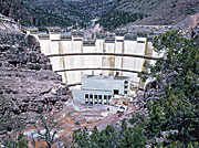
| The Flaming Gorge Dam under construction, US Bureau of Reclamation, 1962 | |||||||||
| Aerial view of the dam at the Flaming Gorge Reservoir | |||||||||
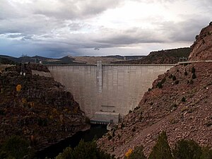
The Flaming Gorge Reservoir is a reservoir in the US states of Wyoming and Utah .
The lake was created by the damming of the Green River by the Flaming Gorge Dam . The construction work on the dam wall was carried out from 1958 to 1964. The reservoir holds a water volume of 4.67 km³ and is located at an altitude of 1,840 meters.
location
Most of the reservoir is in southwestern Wyoming and part of the lake is in northeastern Utah in Daggett County . The northern tip of the reservoir is approximately 10 miles southeast of Green River , 14 miles southwest of Rock Springs, and 70 miles north of Vernal .
There is a hydroelectric power station at the foot of the dam ; there, electricity with a maximum output of 153 MW is generated with three Francis turbines and three generators.
See also
- List of the largest dams on earth
- List of the largest reservoirs on earth
- List of the largest hydroelectric plants in the world
- List of dams in the United States
literature
- Marc Reisner, Cadillac Desert, Viking 1986, ISBN 0-670-19927-3 .


