Hawaii Volcanoes National Park
| Hawaii Volcanoes National Park | ||
|---|---|---|
| Halemaʻumaʻu crater in the caldera of Kīlauea | ||
|
|
||
| Location: | Hawaii , United States | |
| Next city: | Hilo | |
| Surface: | 1,317.68 km² | |
| Founding: | August 1, 1916 | |
| Visitors: | 1,116,891 (2018) | |
| Address: |
Hawaii Volcanoes National Park P.O. Box 52 Hawaii Volcanoes National Park, HI 96718-052 Tel. (808) 985-6000 |
|
| Hawaii Volcanoes National Park | |
|---|---|
|
UNESCO world heritage |
|

|
|
|
Pāhoehoe and ʻAʻā lava in Hawaii |
|
| National territory: |
|
| Type: | nature |
| Criteria : | viii |
| Surface: | 87,940 ha |
| Reference No .: | 409 |
| UNESCO region : | Europe and North America |
| History of enrollment | |
| Enrollment: | 1987 (session 11) |
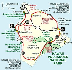
The Hawaii Volcanoes National Park is about 1,348 square kilometers biosphere reserve in the southeast of Hawaii , which since 1987 the UNESCO - World Heritage matters. In addition to extensive lava fields, the area includes the active volcano Kīlauea . The national park's visitor center is one of the island's main tourist attractions.
location
Hawaii is located in the US state of the same name in the Pacific . The lava fields of the national park extend from the Pacific coast to the 4,169 meter high Mauna Loa . They differ greatly in terms of their age and thus the succession levels of their ecosystems .
history
The park was established as Hawaii National Park on August 1, 1916 . Today it is more than twice as large, although in 1961 Haleakalā National Park on the island of Maui was separated as an independent unit. In 1987 it was declared a World Heritage Site.
With the Hawaiian National Park Language Correction Act of 2000 , the United States Senate changed the spelling of the name to Hawaii Volcanoes National Park .
In 2016 the 100th anniversary of the park (" Centennial ") was celebrated. As part of the celebrations, the park offered monthly changing events such as film screenings, lectures, concerts and workshops.
Crater Rim Drive
Along the Crater Rim Drive there are a number of short hiking trails that make it possible to get a good impression of the park even with a one-day visit:
A 0.5 km trail leads from Crater Rim Drive to a lava tube named after Lorrin A. Thurston . Since the eruption in 2018, the Thurston Lava Tube has been closed until further notice as it is in danger of collapsing due to strong earthquakes.
The Kīlauea Iki crater is located on the edge of the Kīlauea caldera . A hike along the Kīlauea Iki Trail (3.9 km, currently closed due to damage from earthquakes) leads down to the surface of a cooled lava lake that was formed during the eruption in 1959. It also leads past the point from where a lava fountain up to 600 meters high emerged. The effects of the 1959 activity can also be seen along the 0.5 mile Devastation Trail.
At the other end of Crater Rim Drive, you got to the Jaggar Museum near the edge of the Halemaʻumaʻu crater by mid-2018 . This was so badly damaged by earthquakes in 2018 that it was closed permanently. Many exhibits have since been on view in the Lava Zone Museum in Pāhoa . In 1924 , a violent explosive eruption also occurred here, caused by groundwater colliding with an underground lava flow. In March 2008 another explosive eruption occurred, which blasted a 30 m hole in the side wall of the crater. Since then, a cloud of sulfur dioxide and volcanic rock in the form of ash and the like has emerged from this opening. Ä. Subsequent explosions gradually enlarged the opening. There was liquid lava in the opening until mid-2018, with the mirror constantly changing. In 2015, the lava reached the top of the opening for the first time. In the second half of 2018, the lava lake emptied completely and the entire region around the crater sank to a depth of up to 400 m.
A section of Crater Rim Drive that had been closed since the 2008 explosion at Halemaʻumaʻu Crater was reopened to pedestrians and cyclists in 2012.
Chain of Craters Road
The road leads down to the coast along a large number of craters and other remnants of volcanic activity. From the Mauna-Ulu parking lot there is a hiking trail (1.6 km in each direction) to Pu'u Huluhulu. From there you have the opportunity to see the Puʻu ʻŌʻō crater. At the end of the street there is a makeshift road created in 2018, which is intended to serve as an evacuation route for places to the west should these be cut off from the public road network by eruptions. The approximately 10 km long route ends in Kalapana and is approved for use on foot or by bike.
Web links
- National Park Service: Hawaii Volcanoes National Park (official site; English)
- Hawaii Volcanoes National Park in the Geographic Names Information System of the United States Geological Survey
- Entry on the UNESCO World Heritage Center website ( English and French ).
Individual evidence
- ↑ Official spelling with ʻOkina according to the Hawaiian National Park Language Correction Act of 2000 (p. 939, English)
- ↑ https://www.nps.gov/havo/getinvolved/100th-anniversary.htm
- ↑ Thurston Lava Tube . Hawaii Volcanoes National Park official web site. Retrieved July 11, 2009.
- ↑ National Park Service: Hawai'i Volcanoes National Park - Park Reopens Keanakākoʻi Crater to Hikers , press release of June 13, 2012
- ↑ https://www.staradvertiser.com/2018/06/01/breaking-news/emergency-lava-evacuation-routes-expected-to-be-completed-saturday/


