Kobuk Valley National Park
| Kobuk Valley National Park | ||
|---|---|---|
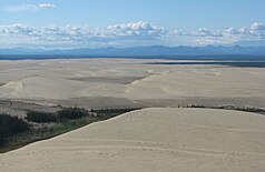
| Great Kobuk sand dunes | ||
|
|
||
| Location: | Alaska , United States | |
| Next city: | Fairbanks | |
| Surface: | 7,084.9 km² | |
| Founding: | 2nd December 1980 | |
| Visitors: | 14,937 (2018) | |
| Address: | Kobuk Valley National Park | |
The Kobuk Valley National Park ( English Kobuk Valley National Park ) in Alaska is one of the most remote national parks in the USA due to its location on the Arctic Circle .
The national park was established on December 2, 1980 by the Alaska National Interest Lands Conservation Act . The park is managed by the World Conservation Union in category II ( national park ).
There is a large valley in the national park, the Kobuk Valley , through which the Kobuk River flows. It is bordered by the Baird and Waring Mountains . A special feature is the 65 square kilometers of Great Kobuk - sand dunes . The sand, created by the grinding action of old glaciers , has been piled up over time by wind and water.
There are no roads that lead into the Kobuk Valley. The journey is usually made by plane from Nome or Kotzebue . In the winter months from October to April it is possible to arrive by snowmobiles, in summer also by boats.
Strong winds blow through the valley all year round. In the short summer, daylight always shines for a month. The harsh winters are extremely cold. Camping, hiking, and wildlife viewing are all possible activities in the park.
Web links
- National Park Service: Kobuk Valley National Park (official site; English)
- Cultural Resources of Kobuk Valley National Park (English)


