Wrangell St. Elias National Park
| Wrangell St. Elias National Park | ||
|---|---|---|
| Mount Saint Elias | ||
|
|
||
| Location: | Alaska , United States | |
| Next city: | Valdez , Cordova , Yakutat | |
| Surface: | 53,602 km² | |
| Founding: | December 2 , 1980 | |
| Visitors: | 79,450 (2018) | |
| Address: | Wrangell - St. Elias National Park | |
The Wrangell St. Elias National Park ( English Wrangell – St. Elias National Park and Preserve ) in southeast Alaska is the largest national park in the United States with around 49,712.61 km² . The national park was founded in 1980 by the Alaska National Interest Lands Conservation Act and, together with the surrounding nature reserves, is a UNESCO World Heritage Site and one of the largest contiguous protected areas in the world. The Preserve is on the World Conservation Union in Category V ( Protected Landscape performed).
getting there

Unlike most other national parks in Alaska, Wrangell St. Elias National Park is relatively well connected to the road network, even if there are only two short road sections in the park itself. The nearest international airport is in Anchorage . The national park can be reached in around four hours by road via the Glenn Highway . At Glennallen , where the main visitor center of the national park is located a little to the south, the Glenn Highway turns into the Richardson Highway and continues south to Valdez , where larger car ferries also dock on the Alaska Marine Highway .
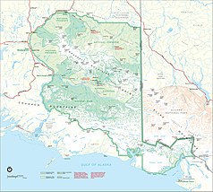
There are only two gravel roads within the boundaries of the national park, although some car rental companies have prohibited driving on these roads. One ( McCarthy Road ) runs 98 km from Chitina on the west side of the park along the Chitina River to McCarthy , the other ( Nabesna Road ) 73 km from Slana in the north to Nabesna .
history
In the park is Kennicott , an abandoned mining settlement for five copper mines nearby. The Kennecott Copper Corporation began in 1908 with the construction of the mine, which was taken in 1911 in operation and attracted numerous workers quickly. In 1938 the last mines were shut down. From there, the copper extracted in this way was transported via McCarthy to Cordova on the Gulf of Alaska by the Copper River and Northwestern Railway . McCarthy became a ghost town after copper mining was shut down and rail traffic ceased . Only in the 1970s, when the region around Kennicott was opened up for tourism, people settled again. The ruins of the Kennicott Mines have survived to this day and are on the National Register of Historic Places . In addition to copper mining, gold was also mined near Nabesna in the north.

The national park was established in 1980 by the Alaska National Interest Lands Conservation Act and is almost six times the size of Yellowstone National Park . There are three different protection zones within the park; part of it is designated as a National Preserve , where the level of protection is lowest. Here mining or hunting is permitted both as a traditional use by the indigenous people, as well as for foreigners and commercially. Mining is still practiced on a small scale in private parts of the National Preserve. The Wrangell-Saint Elias Wilderness with 36,732.3 km² is designated as a Wilderness Area , the strictest class of nature reserves in the United States. It is the core zone of the national park and at the same time the largest wilderness area in the USA, making up ten percent of the entire National Wilderness Preservation System.
Together with the Canadian Kluane National Park in the Yukon Territory , the Glacier Bay National Park & Preserve in the extreme southeast of Alaska on the Gulf of Alaska and the Tatshenshini-Alsek Provincial Park in British Columbia (Canada), the park has been a World Heritage Site since 1994 . With a total area of 97,124 km², this protected area is one of the largest in the world.
geography

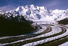
9 of the 16 tallest mountains in the United States are in Wrangell-St.-Elias National Park. Most of the mountains of the Wrangell Mountains with the 4316 m high volcano Mount Wrangell , which last erupted in 1930, meet the world's highest coastal mountain range, the Saint Elias Mountains with the highest point in the park, Mount Saint Elias (5489 m) on the Gulf of Alaska . . In addition, the Chugach Mountains in the southwest and the foothills of the Alaska range in the north (with the Nutzotin and Mentasta Mountains ) meet here. The latter represent the northern boundary of the park, while in the west the park boundary runs along the Copper River .
There are countless glaciers within the boundaries of the national park. The Bagley Icefield is the largest subpolar ice field in North America in the Chugach Mountains. It feeds numerous large glaciers such as the Malaspina Glacier , the Hubbard Glacier or the Bering Glacier , which with an area of 5200 km² and a length of 190 km is both the largest and longest glacier in North America.
Flora Fauna
Wolves, mountain goats , black bears , grizzly bears , moose and caribou belong to the rich world of large animals in this huge wilderness , little touched by civilization . In addition, one of the largest populations of the Dall sheep (approx. 13,000 animals) and two herds of bison that have resettled here live here . The puma may also appear in the park. In addition, Canada lynx , coyote and wolverine are the largest predators in the area, alongside bears and wolves . Smaller mammals in the national park are red fox, North American otter, beaver, urson , ice-gray marmot, snowshoe hare, arctic ground squirrel, flying squirrel, red squirrel, whistle rabbit and various small rodents such as lemmings. Whales, sea otters, seals and sea lions live in the coastal waters . About 80 percent of the land area consists of snow, ice and rocks. Due to the harsh climate, apart from the extensive spruce forests in the lower elevations, mainly dwarf shrubs and grasses occur, but there is a great diversity of species. Typical shrubs are the blueberry and the needle rose .
Web links
- National Park Service: Wrangell St. Elias National Park (official site; English)
- Cultural Resources of Wrangell-St. Elias National Park and Preserve (English)
- Entry on the UNESCO World Heritage Center website ( English and French ).
Individual evidence
- ↑ World Database on Protected Areas - Wrangell – St. Elias National Park and Preserve (English)
- ↑ Eire, Jumbo, Mother Lode, Bonanza and Glacier Mine, see Kennecott Mines circa 1920. Map of the mining region. National Park Service , US Department of the Interior , accessed February 15, 2018 .
- ↑ US National Park Service: Wrangell-St. Elias National Park - Mammal Checklist , PDF (November 2015)


