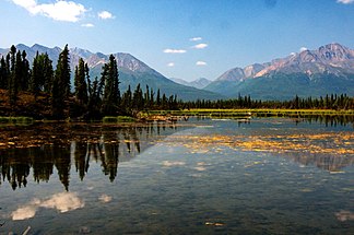
Mentasta Mountains
| Mentasta Mountains | ||
|---|---|---|
|
View from Tok Cut-Off of the Mentasta Mountains |
||
| Highest peak | Noyes Mountain ( 2483 m ) | |
| location | Alaska (USA) | |
|
|
||
| Coordinates | 62 ° 36 ′ N , 143 ° 4 ′ W | |
The Mentasta Mountains are a mountain range in eastern Alaska with a maximum height of 2315 m . They are partially located in Wrangell-St.-Elias National Park and the Tetlin National Wildlife Refuge and form the eastern end of the Alaska range .
The boundaries of the mountain range form the Slana River in the west, the Jack Creek in the south, the Nabesna River in the east and Station Creek and Tuck Creek in the north. The Tok Cut-Off runs west of the Mentasta Mountains and the Alaska Highway runs north . The Wrangell Mountains connect to the south and the Nutzotin Mountains to the east .
The name is derived from the aboriginal name for a pass in the northwest of the mountain range and was documented by DC Witherspoon from the United States Geological Survey in 1902 .
Individual evidence
- ↑ Mentasta Mountains Range - Alaska Mountain Peak Information on mountainzone.com
- ↑ Wrangell-St. Elias National Park and Preserve: What's So Special About This Place? ( Memento of the original from August 30, 2008 in the Internet Archive ) Info: The archive link was automatically inserted and not yet checked. Please check the original and archive link according to the instructions and then remove this notice. on nps.gov

