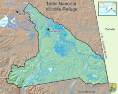
Tetlin National Wildlife Refuge
| Tetlin National Wildlife Refuge | ||
|---|---|---|
| Autumn landscape in Tetlin NWR | ||
|
|
||
| Location: | Alaska , United States | |
| Next city: | Tetlin | |
| Surface: | 2833 km² | |
| Founding: | 2nd December 1980 | |
The Tetlin National Wildlife Refuge is a 2833 km² protected area in the National Wildlife Refuge System of the United States . The refuge is located in eastern Alaska on the border with the Canadian Yukon Territory . The Alaska Highway forms the northern limit for 105 km. The Alaska range is to the west and the Wrangell-St.-Elias National Park connects to the south . The administration of the sanctuary is located in Tok .
The Tetlin National Wildlife Refuge is located in a landscape defined by forests, wetlands , tundra , lakes, mountains and glacial rivers. The majority of the area consists of hilly flat land, only in the south-west rises a mountain range with the glaciated Mentasta Mountains .
Wildlife
The reserve's vegetation consists of boreal forest , tundra, and scrub with wetlands and rivers . 115 of the 186 bird species sighted, such as the trumpeter swan , which visits the remote lakes and ponds, use the area as a nesting site. 25 species also live here in winter.
Moose feed on the plants of the wetlands and caribou wander through the refuge on the way between their summer and winter locations. Dall sheep live on the mountain slopes in the south. In addition to the lynx , martens , mink , muskrat , beaver and wolf , grizzlies and black bears also have a habitat in the refuge.
history
Until the late 19th century, athabasques lived largely without contact with the outside world on the Tanana River in the region of today's protected area. They lived as hunters and gatherers and followed the migratory routes of the caribou . Russian explorers explored the lower reaches of the Copper River at that time , but without penetrating into the area of the Tanana. It was not until 1885 that a United States Army expedition reached the Tanana Valley. Early contacts between the Athabascans and Europeans were through traders who sailed the Yukon .
The construction of the Alaska Highway in 1942 did much to develop the Tanana Valley . In 1980, the National Wildlife Refuge was established under the Alaska National Interest Lands Conservation Act . In contrast to most national parks, the reserve also serves to enable the indigenous people, known as locals , to practice their traditional way of life. The protected area is managed by the World Conservation Union in category IV ( biotope and species protection area ).
- Landscapes of the Tetlin National Wildlife Refuge
Web links
- US Fish & Wildlife Service: Tetlin National Wildlife Refuge (official site; English)


