Kanuti National Wildlife Refuge
| Kanuti National Wildlife Refuge | ||
|---|---|---|
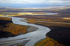
| The Koyukuk River in the Kanuti National Wildlife Refuge | ||
|
|
||
| Location: | Alaska , United States | |
| Next city: | Ruby | |
| Surface: | 5788 km² | |
| Founding: | 2nd December 1980 | |
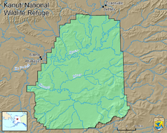
The Kanuti National Wildlife Refuge is a 5788 km² protected area in the National Wildlife Refuge System of the United States . It is located in the interior of Alaska and includes large parts of the catchment areas of the Koyukuk and Kanuti River on the Arctic Circle west of the Dalton Highway .
The refuge was established in 1980 under the Alaska National Interest Lands Conservation Act and is administered by the United States Fish and Wildlife Service . It is listed in Category IV ( Biotope and Species Protection Area ) by the World Conservation Union .
To the north of the reserve are the settlements of Bettles and Evansville , to the west of Alatna and Allakaket .
The weather in the region of the refuge is characterized by short, hot summers with thunderstorms and lightning strikes, which often trigger fires. These fires maintain a cycle of destruction and regeneration that enables the diverse habitats in the protected area.
The wetlands and lakes on the rivers form water bird breeding areas in which about 130 bird species live seasonally or year-round.
The boreal coniferous forest with white and black spruce as well as occasional birch and poplar offers a habitat among other things, elks , wolves , lynxes , wolverines , black and brown bears . Two of Alaska's major herds of caribou , the Western Arctic and Ray Mountain herds, roam the reserve area.
Web links
- US Fish & Wildlife Service: Kanuti National Wildlife Refuge (official site; English)


