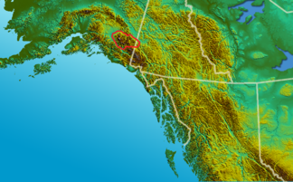
Wrangell Mountains
| Wrangell Mountains | ||
|---|---|---|
|
Wrangell Mountains (outlined in red) |
||
| Highest peak | Mount Blackburn ( 4996 m ) | |
| location | Alaska (USA), Yukon Territory (Canada) | |
|
|
||
| Coordinates | 61 ° 44 ′ N , 143 ° 26 ′ W | |
|
Mount Blackburn and Kennicott Glacier |
||
The Wrangell Mountains are a mountain range up to 4996 m high in the southeast of Alaska ( USA ) and in the southwest of the Yukon Territory ( Canada ). They are about 62 ° north latitude and between 142 ° and 145 ° west longitude.
The mountain range connects directly to the northwest to the Elias chain , which lies along the coast of the Gulf of Alaska . The 1777 m high Chitistone Pass forms the transition to the Elias chain . The Wrangell Mountains shield the inland areas from the warmer, humid air of the Pacific , making the areas north of the mountain range some of the coldest areas in North America in winter .
Most of the mountains of the mountain range belonging to the USA are in Wrangell-St.-Elias National Park , most of the mountains of the Canadian part in Kluane National Park .
| summit | Sea level | Notch height | Dominance |
|---|---|---|---|
| Mount Blackburn | 4996 m | 3533 m | 97.6 km |
| Mount Sanford | 4949 m | 2328 m | 64.8 km |
| Mount Wrangell | 4317 m | 1696 m | 23.8 km |
| Atna Peaks | 4225 m | 659 m | 5.9 km |
| Regal Mountain | 4220 m | 1324 m | 19.7 km |
| Mount Jarvis | 4091 m | 1439 m | 18.0 km |
| Parka Peak | 4048 m | 268 m | 2.6 km |
| Mount Zanetti | 3965 m | 277 m | 4.2 km |
There are several volcanoes in the Wrangell Mountains:
- Capital Mountain
- Mount Drum
- Mount Jarvis
- Mount Sanford
- Tanada Peak
- Mount Wrangell
Web links
- AVO description Wrangell Volcanic Field (English)


