
Mount Blackburn
| Mount Blackburn | ||
|---|---|---|
 View across Kennicott Glacier to Mount Blackburn |
||
| height | 4996 m | |
| location | Alaska , USA | |
| Mountains | Wrangell Mountains | |
| Dominance | 97 km → Mount Bona | |
| Notch height | 3533 m ↓ Skolai Pass | |
| Coordinates | 61 ° 43 '54 " N , 143 ° 25' 59" W | |
| Topo map | USGS McCarthy C-7 | |
|
||
| Type | eroded shield volcano | |
| rock | Granite , andesite | |
| Age of the rock | Pliocene | |
| First ascent | 1958 by Bruce Gilbert, Dick Wahlstrom, Hans Gmoser, Adolf Bitterlich and Leon Blumer | |
| Normal way | Glacier trails over the north ridge | |

At 4996 m, Mount Blackburn is the highest peak in the Wrangell Mountains in Alaska . It is also the fifth highest mountain in the United States and the twelfth highest in North America . The heavily eroded shield volcano is the highest volcano in the United States after Mount Bona and the fifth highest in North America. In 1885 Henry T. Allen named it after the US Senator Joseph Clay Stiles Blackburn from Kentucky .
The mountain massif is almost completely covered by ice fields and glaciers . Below is the 32 km long Kennicott Glacier , which stretches to just before the small town of McCarthy . Mount Blackburn's ice fields also feed the Nabesna and Kuskulana glaciers. The volcano rises 3350 m above the latter at a distance of only six kilometers. With its notch height of 3546 m, the mountain ranks 50th worldwide.
First ascents
In 1912 Dora Keen and George Handy made the first ascent to Mount Blackburn. The team reached the eastern summit, called Kennedy Peak or East Blackburn , from the south on a route that was dangerous because of crevasses , which at that time was still considered the highest point of the mountain. Keen subsequently published the report First up Mount Blackburn in the Saturday Evening Post . In 1958, five climbers attempted the ascent to the western peak without knowing that it was the higher of the two. A year later, one of the climbers published an article in the American Alpine Journal entitled Mount Blackburn - Second Ascent ( - Second Ascent ). It was not until the 1960s that the first US Geological Survey maps marked the western summit as the highest point.
Today the route is normally taken from the north, as in 1958. It runs along the Nabesna Glacier .
photos

The Nabesna Glacier, the Atna Peaks in the background to the left , Mount Blackburn with its two peaks on the right
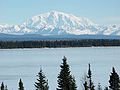
View over Willow Lake further west to Mount Blackburn

