Atna Peaks
| Atna Peaks | ||
|---|---|---|
|
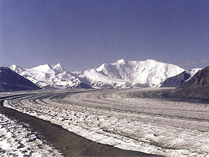
The Nabesna Glacier in front of Mount Blackburn (center), Atna Peaks (double peaks on the left ) and Parka Peak (snow-capped peak on the left edge of the picture) |
||
| height | 4225 m | |
| location | Alaska , USA | |
| Mountains | Wrangell Mountains | |
| Dominance | 6 km | |
| Notch height | 659 m | |
| Coordinates | 61 ° 44 '58 " N , 143 ° 14' 23" W | |
| Topo map | USGS McCarthy C-6 | |
|
|
||
| First ascent | 1965 by Alex Bittenbinder, Don Stockard, Vin Hoeman | |
Atna Peaks is a 4225 m high stratovolcano in the Wrangell Mountains near the border of Alaska with the Canadian Yukon Territory .
Atna Peaks is located about 10 km northeast of Mount Blackburn and 39 km northwest of McCarthy in Wrangell-St.-Elias National Park .
The first ascent took place in 1965 by Alex Bittenbinder, Don Stockard and Vin Hoeman.
Atna Peaks was named in 1965 by the Mountaineering Club of Alaska after the name of the indigenous people of Alaska for the Copper River , on the edge of whose catchment area the mountain lies.

