Bering Land Bridge National Preserve
| Bering Land Bridge National Preserve | ||
|---|---|---|
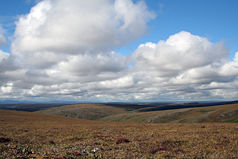
| Tundra at Cottonwood Creek | ||
|
|
||
| Location: | Alaska , United States | |
| Next city: | Kotzebue | |
| Surface: | 10,922 km² | |
| Founding: | December 1, 1978 | |
| Visitors: | 796 (2007) | |
The Bering Land Bridge National Preserve is a nature reserve under the administration of the National Park Service in the north of the Seward Peninsula of Alaska at the transition of the Kotzebue Sound to the Chukchi Sea . Cape Espenberg , the northernmost point of the protected area, lies a few kilometers above the Arctic Circle . The continental watershed , which separates the catchment areas of the Pacific and the Arctic Ocean , runs through the southern part of the preserve.
The remains of Beringia , a land bridge between North America and Asia that existed during the Ice Age of the Pleistocene until about 10,000 years ago , over which the first people from Siberia immigrated to the American continent , are under protection .
The reserve was established as a National Monument on December 1, 1978 . On December 2, 1980, the Alaska National Interest Lands Conservation Act changed its status to that of a National Preserve .
The Bering Land Bridge National Preserve contains several sites of geological and prehistoric importance. The hot springs of Serpentine Hot Springs have been used by the indigenous people of Alaska used. 8,500 year old stone tools have been found in the Trail Creek Caves , a group of twelve caves . The Lost Jim Lava Flow is a lava flow from the Holocene .
There are no roads into the area. In summer it can be reached by plane or ship, in winter also by snowmobiles or dog sleds.
Web links
- National Park Service: Bering Land Bridge National Preserve (official site; English)
- Geology Field Notes: Bering Land Bridge National Preserve (English)
- Cultural Resources in Bering Land Bridge National Preserve (English)
- From Hunters to Herders: The Transformation of Earth, Society, and Heaven among the Inupiat of Beringia (PDF file, 3.6 MB )


