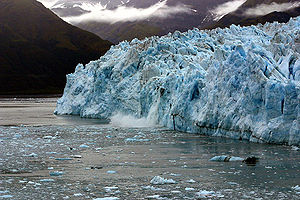
Hubbard Glacier
| Hubbard Glacier | ||
|---|---|---|
| location | Alaska (USA), Yukon (Canada) | |
| Mountains | Elias chain | |
| Type | Outlet glacier | |
| length | 122 km | |
| Exposure | South southeast | |
| Altitude range | 2400 m - 0 m | |
| width | ⌀ 4.9 km | |
| Coordinates | 60 ° 1 ′ N , 139 ° 30 ′ W | |
|
|
||
| drainage | Disenchantment Bay ( Yakutat Bay ) | |
|
Map of the Hubbard Glacier. The imminent separation of Russell Fjord and Disenchantment Bay is easy to see. |
||
The Hubbard Glacier is a glacier in the Elias Range in the US state of Alaska and the Yukon Territory of Canada .
From its source in the Yukon Territory, the glacier extends 122 km into Disenchantment Bay and Yakutat Bay . This makes it the longest glacier in Alaska that ends in a body of water. Its front side measures over ten kilometers. Before the glacier reaches the water, it joins the Valerie Glacier coming from the west , which experts believe will ensure that the Hubbard Glacier permanently separates the Russell Fjord from Disenchantment Bay with its thrust . In May 1986 and in the spring of 2002 this happened for a few months, creating Russell Lake . After the influx of the fjord in 1986 caused the level to rise 25 meters above sea level over the summer, the dam broke around midnight on October 8, 1986 and the fjord was reconnected to the ocean. It was the second largest man-documented glacier run .
Web links
- Hubbard Glacier in the United States Geological Survey's Geographic Names Information System
- US Geological Survey: Pictures from the blockade in 2002
Individual evidence
- ↑ National Park Service : Hubbard Glacier: Geology in Action! ( Memento from September 24, 2008 in the Internet Archive )
- ^ USGS Report: Hubbard Glacier, Alaska: Growing and Advancing in Spite of Global Climate Change and the 1986 and 2002 Russell Lake Outburst Floods. US Geological Survey, accessed September 21, 2007 .


