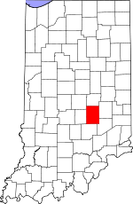
Shelby County, Indiana
Shelby County | |
|---|---|
 Location within the U.S. state of Indiana | |
 Indiana's location within the U.S. | |
| Coordinates: 39°31′N 85°47′W / 39.52°N 85.79°W | |
| Country | |
| State | |
| Founded | 1821 |
| Seat | Shelbyville |
| Area | |
| • Total | 413 sq mi (1,070 km2) |
| • Land | 413 sq mi (1,070 km2) |
| • Water | 0 sq mi (0 km2) 0.11% |
| Population (2000) | |
| • Total | 43,445 |
| • Density | 110/sq mi (41/km2) |
| Website | www |
Shelby County is a county located in the U.S. state of Indiana. As of 2000, the population was 43,445. Its estimated 2005 population was 43,766. The county seat is Shelbyville6.
Geography
According to the U.S. Census Bureau, the county has a total area of 1,070 km² (413 sq mi). 1,069 km² (413 sq mi) of it is land and 1 km² (0 sq mi) of it (0.11%) is water.
Adjacent counties
- Hancock County (north)
- Rush County (east)
- Decatur County (southeast)
- Bartholomew County (south)
- Johnson County (west)
- Marion County (northwest)
Demographics
| Shelby County Population by year | |
|
2005 43,766 | |
As of the census² of 2000, there were 43,445 people, 16,561 households, and 12,056 families residing in the county. The population density was 41/km² (105/sq mi). There were 17,633 housing units at an average density of 16/km² (43/sq mi). The racial makeup of the county was 97.26% White, 0.76% Black or African American, 0.19% Native American, 0.59% Asian, 0.02% Pacific Islander, 0.50% from other races, and 0.68% from two or more races. 1.14% of the population were Hispanic or Latino of any race. 31.1% were of German, 28.3% American, 11.9% English and 9.7% Irish ancestry according to Census 2000.
There were 16,561 households out of which 34.70% had children under the age of 18 living with them, 59.20% were married couples living together, 9.30% had a female householder with no husband present, and 27.20% were non-families. 22.70% of all households were made up of individuals and 9.50% had someone living alone who was 65 years of age or older. The average household size was 2.58 and the average family size was 3.02.
In the county the population was spread out with 26.70% under the age of 18, 8.00% from 18 to 24, 30.60% from 25 to 44, 22.60% from 45 to 64, and 12.20% who were 65 years of age or older. The median age was 36 years. For every 100 females there were 98.00 males. For every 100 females age 18 and over, there were 95.80 males.
The median income for a household in the county was $43,649, and the median income for a family was $51,271. Males had a median income of $36,809 versus $25,021 for females. The per capita income for the county was $20,324. About 4.80% of families and 7.60% of the population were below the poverty line, including 9.70% of those under age 18 and 8.50% of those age 65 or over.
History
Shelby County was organized in 1821. It was named for Gen. Isaac Shelby, who defeated the British at the Battle of Kings Mountain in the Revolutionary War. Shelby then became the first Governor of Kentucky. During the War of 1812, he led the army of Kentucky into Canada, and defeated the British at the decisive Battle of the Thames in 1813.
George W. Clarke, Governor of Iowa from 1913 to 1917, was born in Shelby County, Indiana, on Oct. 24, 1852.
Cities and towns
Townships
- Addison
- Brandywine
- Hanover
- Hendricks
- Jackson
- Liberty
- Marion
- Moral
- Noble
- Shelby
- Sugar Creek
- Union
- Van Buren
- Washington
References
- Forstall, Richard L. (editor) (1996). Population of states and counties of the United States: 1790 to 1990 : from the twenty-one decennial censuses. United States Department of Commerce, Bureau of the Census, Population Division. ISBN 0-934213-48-8.
{{cite book}}:|first=has generic name (help)
