Kelardasht


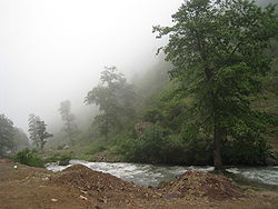
Kelardasht is a large valley in the Elborz Mountains of northern Iran in Chalus county, Mazandaran province. It's 30km south of Abbasabad city (on the Caspian Sea) and west of Marzanabad city (on Chalus Road). There are 20,000 inhabitants and 30 villages.[1]
Kelardasht City is the center of the Kelardasht area. In 1996 the population was 5131, or 1191 families. The city is comprised of 5 districts. Hasankif has been the business district for many years and is currently also the political center. [2]
Originally a farming area, in recent years much of its land was sold in small lots to build numerous villas [3] which are occupied by summer visitors trying to escape the heat of Tehran and points further south. Arabs from the Gulf states can also be seen there during the summer months.
Its attractions mainly consist of its natural beauty and cooler climate. But picnicing and mountain climbing in the area surrounding Rud Barak is also popular, as well as in the lush Abbasabad Forest nearby.
The Kelardasht area has enclaves of Kurmanji-speaking Iranian Kurds. They practice the Dervish variation of Islam. There are also enclaves of people from Gilan province. [4]
Link
References
- ^ http://malinga.net/
- ^ Saeidian, Abdolhossein. Know the Cities of Iran [Farsi title is Shenakht-e Sharha-ye Iran]. Alam va Zendagi, Tehran 2000. Second printing 2004. Pages 705-708. [Text is in Farsi]
- ^ Pur, Ali Malek. Kelardasht (geography, History & Culture). Tehran: Kar Afrinan, 1999.
- ^ Pur, Ali Malek. Kelardasht (geography, History & Culture).
