
Long Beach, Washington
Long Beach, Washington | |
|---|---|
 The Pacific Ocean from a beach near Long Beach | |
 Location of Long Beach, Washington | |
| Country | United States |
| State | Washington |
| County | Pacific County |
| Incorporated | January 18, 1922 |
| Government | |
| • Type | Mayor-council |
| • Mayor | Bob Andrew[1] |
| Area | |
| • Total | 3.3 km2 (1.3 sq mi) |
| • Land | 3.3 km2 (1.3 sq mi) |
| • Water | 0.0 km2 (0.0 sq mi) |
| Elevation | 15.2 m (10 ft) |
| Population (2000) | |
| • Total | 1,283 |
| • Density | 393.2/km2 (1,018.7/sq mi) |
| Time zone | UTC-8 (PST) |
| • Summer (DST) | UTC-7 (PDT) |
| ZIP code | 98631 |
| Area code | 360 |
| FIPS code | 53-40070Template:GR |
| GNIS feature ID | 1512400Template:GR |
| Website | http://www.longbeachwa.gov/ |
Long Beach is a city in Pacific County, Washington, United States. The population was 1,283 at the 2000 census. It is the home of Northwestern pop cultural phenomenon Jake the Alligator Man.
Geography
Long Beach is located at 46°21′3″N 124°3′13″W / 46.35083°N 124.05361°WInvalid arguments have been passed to the {{#coordinates:}} function (46.350959, -124.053643)Template:GR on the Long Beach Peninsula.
According to the United States Census Bureau, the city has a total area of 1.3 square miles (3.3 km²), all of it land.
Demographics
As of the censusTemplate:GR of 2000, there were 1,283 people, 660 households, and 314 families residing in the city. The population density was 1,018.7 people per square mile (393.2/km²). There were 1,155 housing units at an average density of 917.1/sq mi (353.9/km²). The racial makeup of the city was 89.87% White, 0.08% African American, 1.09% Native American, 1.40% Asian, 1.56% from other races, and 6.00% from two or more races. Hispanic or Latino of any race were 4.83% of the population. 19.6% were of German, 11.5% Irish, 10.3% English, 6.3% American and 5.7% Norwegian ancestry according to Census 2000.
There were 660 households out of which 17.0% had children under the age of 18 living with them, 34.2% were married couples living together, 11.8% had a female householder with no husband present, and 52.3% were non-families. 43.8% of all households were made up of individuals and 20.5% had someone living alone who was 65 years of age or older. The average household size was 1.92 and the average family size was 2.63.
In the city the population was spread out with 17.6% under the age of 18, 5.8% from 18 to 24, 23.1% from 25 to 44, 28.9% from 45 to 64, and 24.5% who were 65 years of age or older. The median age was 47 years. For every 100 females there were 81.2 males. For every 100 females age 18 and over, there were 77.9 males.
The median income for a household in the city was $23,611, and the median income for a family was $33,029. Males had a median income of $30,938 versus $20,625 for females. The per capita income for the city was $21,266. About 13.4% of families and 18.7% of the population were below the poverty line, including 19.5% of those under age 18 and 11.4% of those age 65 or over.
History
Long Beach began when Henry Harrison Tinker bought a land claim from Charles E. Reed in 1880. He platted the town and called it "Tinkerville."[2] Long Beach was officially incorporated on January 18, 1922. From 1889 to 1930, a narrow gauge railroad called the Ilwaco Railway and Navigation Company ran up the whole peninsula.
The Long Beach depot was built between First and Second Streets on the east side of the track, which ran north along "B" Street.[3] A major destination in Long Beach was Tinker's Hotel, later renamed the Long Beach Hotel, and built very close to the station. This was the second hotel built at the site by Henry Harrison Tinker, the founder of Long Beach Tinker's first hotel burned down in 1894. He built another one just a few feet to the east and south of the rail depot.[4] The image in the gallery shows a crowd waiting for the train sometime between 1901 and 1907. Just across the tracks (which doubled in this area)[5] from Tinker's Hotel in Long Beach was the Portland Hotel. The Portland Hotel, owned by the Hanniman family was unique for the area, in that it featured an enormous round turret-like structure.The Portland Hotel burned down on December 6, 1914, and was not replaced. [6] The Driftwood Hotel was another common Long Beach destination.
The boardwalk area near the station was known as "Rubberneck Row."[7] Businesses existing in August of 1911 that can be identified along Rubberneck Row from photographs (see images in this article) include, on the west side of the tracks, an establishment advertising "Baths" (possibly the Crystal Baths, an indoor swimming pool), Milton York Candies, a "Postal Shop," and a soda fountain just across from the station advertising "Milk Shake." A somewhat earlier photograph shows a sign for a livery stable immediately to the west across the tracks from Tinker's Hotel, followed (proceeding southwards) by a barber ship, "Vincent's Souvenirs," and a candy shop. A banner stretching above the tracks advertises a restaurant. The photo published by Feagans shows it was produced by H.A. Vincent, Ilwaco and Long Beach, who was probably the owner of Vincent's Souvenirs.[8]
Gallery
-
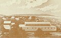 Crystal Baths, Long Beach, WA, about 1905, looking south towards Cape Disappointment (high land in background)
 -
 Long Beach, WA, July 1909 "Rubberneck Row," looking north towards depot (building with 2 windows in distance just to right of telegraph pole)
 -
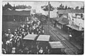 Waiting for train, Long Beach, WA, August 1911, looking south, probably from depot window or roof
 -
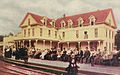 Tinker's Hotel, Long Beach, WA, looking east
 -
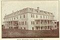
 Long Beach (formerly Tinker's Hotel), April 1953
 -
 Breakers Hotel, Long Beach, WA, looking east from beach
 -
 Breakers Hotel looking west


its really gay town never come here o and ur gay
References
- ^ "City Government of Long Beach, Washington: MAYOR". City of Long Beach, Washington. 2008. Retrieved 2008-03-25.
- ^ Hobbs, Nancy L., and Lucero, Donella J., The Long Beach Peninsula, at page 15, Arcadia Publishing 2005 ISBN 0-7385-2995-8
- ^ Feagans, at 37
- ^ Hobbs and Lucero, Long Beach Peninsula, at 24
- ^ Feagans, at 71 states that a passing siding was built at Long Beach
- ^ Hobbs and Lucero, Long Beach Peninsula, at 24
- ^ Feagans, at 23, publishing post card showing area with caption "Long Beach, Wash. Rubberneck Row," from the Pacific County Historical Society
- ^ Feagans, at 23, reprinting postcard from Pacific County Historical Society
Municipalities and communities of Pacific County, Washington, United States | ||
|---|---|---|
| Cities | 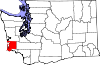 | |
| CDPs | ||
| Other communities | ||
| Ghost towns | ||
| Indian reservation | ||