Long Beach Peninsula
| Long Beach Peninsula | ||
 |
||
| Geographical location | ||
|
|
||
| Coordinates | 46 ° 28 ′ N , 124 ° 3 ′ W | |
| Waters 1 | Pacific Ocean , Willapa Bay | |
| Waters 2 | Columbia River | |
| length | 45 km | |
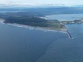
 Cape Disappointment on the southern tip of the Long Beach Peninsula |
||
Long Beach Peninsula (English: long beach for "long beach" and peninsula for "peninsula") is a 45 kilometer long peninsula on the Pacific coast in the US state of Washington . It is bordered to the south by the Columbia River , to the west by the Pacific and to the east by Willapa Bay . The northern tip is called Leadbetter Point , the southern tip to the mouth of the Columbia River is called Cape Disappointment .
history
Cape Disappointment was named in 1788 by the English captain John Meares during an unsuccessful search for the Northwest Passage . He called the northern tip Low Point . Cape Disappointment was the westernmost point that the Lewis and Clark Expedition reached in 1805. Low Point was renamed Leadbetter Point in 1852 in honor of Danville Leadbetter , a US coastal survey officer . The place Oysterville was founded in 1854 and became prosperous through oyster fishing. The Cape Disappointment Lighthouse was built in 1856 and is now the oldest functioning lighthouse on the US west coast. During the Civil War , a fort was built at Cape Disappointment in 1862 to protect the mouth of the Columbia River. In 1875 this fortification was renamed Fort Canby and in 1896 fortified with the addition of Fort Columbia . The two coastal forts were used for military purposes until the end of World War II.
geography
The Long Beach Peninsula has the longest sandy beach on the US Pacific coast at 45 kilometers. Cars are allowed on the beach, so the peninsula's tourist office has named it "the longest sandy beach in the world that can be driven on by cars". There are four state parks on the peninsula:
- At the northern tip is Leadbetter Point State Park and the adjacent Willapa National Wildlife Refuge to the north
- The small, only four hectare Pacific Pines State Park in Ocean Park was originally intended to be developed as building land, but now serves as a picnic area and allows free access to the sandy beach on the Pacific coast.
- The Loomis Lake State Park Six kilometers south of the city Ocean Park. The park is divided into two parts. A 5.5 hectare area serves as a picnic area and free access to the sandy beach on the Pacific coast. The eponymous, four kilometer long Loomis Lake does not belong to this part. The lake, four kilometers long, the largest lake on the Long Beach Peninsula, borders the 113 hectares of the much larger part of the state park. This area serves as a bird sanctuary for the Trumpeter Swan and is not accessible. The lake and the park were named after Louis Loomis , a shipowner from the 19th century.
- The southern tip of the peninsula is covered by the 7.6 square kilometer Cape Disappointment State Park , which has a large campground, two lighthouses, the relics of Fort Canby as well as originally preserved coastal forest and saltwater marshes.
economy
Due to its sandy beach and easy access from Portland and Seattle, the Long Beach Peninsula is now a center of tourism. The towns of Ilwaco , Long Beach and Seaview are particularly characterized by tourism. The place Oysterville is completely under monument protection. The oyster fishery is no longer of great importance on the peninsula.
literature
- Marge Mueller, Ted Mueller: Washington State Parks: a Complete Recreation Guide. 2004, ISBN 978-0-89886-642-1
- Baedeker: USA - North West, Ostfildern 2009, ISBN 978-3-8297-1181-4
