
Pyrmont, New South Wales
| Pyrmont Sydney, New South Wales | |||||||||||||||
|---|---|---|---|---|---|---|---|---|---|---|---|---|---|---|---|
 Pyrmont, New South Wales | |||||||||||||||
| Population | 11088 (2006 census) | ||||||||||||||
| • Density | Lua error: Unable to convert population "11088 (2006 census)" to a number. | ||||||||||||||
| Postcode(s) | 2009 | ||||||||||||||
| Area | 1 km2 (0.4 sq mi) | ||||||||||||||
| Location | 2 km (1 mi) west of Sydney CBD | ||||||||||||||
| LGA(s) | City of Sydney | ||||||||||||||
| Parish | St. Andrew | ||||||||||||||
| State electorate(s) | Sydney | ||||||||||||||
| Federal division(s) | Sydney | ||||||||||||||
| |||||||||||||||
Pyrmont is an inner-city suburb of Sydney, in the state of New South Wales, Australia. Pyrmont is located 2 kilometres south-west of the Sydney central business district in the local government area of the City of Sydney. It is also part of the Darling Harbour region.
History
Pyrmont contained a mineral spring of cold water bubbling out of a rock and was thus named for a similar natural spring in Bad Pyrmont, close to Hanover, Germany.[1] The area was also the site of the first Presbyterian Church in the colony, built in 1864 and situated in Mount Street. The congregation eventually outgrew the premises and had to move to a new church at Quarry Street, Ultimo.[2]
Aboriginal Culture
Before European settlement the Eora tribe of Indigenous Australians inhabited the area. Their Aboriginal name for this area was 'Pirrama', which is still the name of a road on the Pyrmont waterfront.
European Settlement
Thomas Jones was granted 55 acres of land on the peninsula in 1795. Land was sold to Obadiah Ikin in 1796 for 10 pounds, which he then sold to Captain John Macarthur in 1799 for a gallon of rum.[3]
In 1900 the area had a population of over 30,000. But by 1991 the population had dramatically dropped to around 900. leaving the area to become derelict. In order to combat this problem the government initiated the “better city’s program” to improve the area. This led to a larger community and also an increase of trade with businesses moving back into the area.
Pyrmont became a working class industrial and port community. It was considered to be a slum area in the 19th century. [4] A major sugar refinery was operated by CSR Limited. Almost all industrial function is gone from the area now, replaced by high-rise residential developments (such as Jackson's Landing). The first Pyrmont Bridge opened in 1858. A larger bridge with a swinging span opened in 1902.
Landmarks
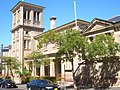
Pyrmont Fire Station in Pyrmont Street was designed by the Government Architect, Walter Liberty Vernon, in 1907. It is an example of the Federation Free Style, predominantly made of brick with sandstone trimmings, and with Art Nouveau elements. It is now on the Register of the National Estate.[5]
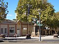
The public school in John Street was designed by W.E.Kemp and built in 1891; a brick building, it features a bell tower, belfry and slate roof, and is on the Register of the National Estate.[6]
Pyrmont Square is a major heritage precinct. It includes the Post Office in Harris Street, the Duke of Edinburgh Hotel, two bank buildings in Union Street, the homes from 4-20 Union Street, all buildings from 99-125 Harris Street, the terrace from 135-141 Harris Street and terraces from 1-21 Paternoster Road. All of these buildings are listed on the Register of the National Estate.[7] Also on the Register is the Waite and Bull building at 137 Pyrmont Bridge Road.[8]
-
 Pyrmont Public School
 -
 Pyrmont Fire Station, Pyrmont Street
 -
 Pyrmont square
 -
 Pyrmont Bridge mid-swing


Commercial Areas
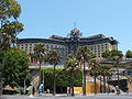
The Star City Casino dominates the Darling Harbour waterfront of Pyrmont and the Sydney Fish Market is located on Blackwattle Bay.
Pyrmont is home to the headquarters of several corporations including Vodafone and Nokia Australia, the Network Ten studios, the Seven Network production studios,, radio stations Nova 96.9 Vega 95.3,2GB and 2SM.
Jackson's Landing is a residential and commercial property development located on the northern part of the peninsula.
-
 Channel Ten Studios
 -
 Nova 96.9 Studios
 -
 Star City casino, front
 -
 Star City casino, back


Transport
Pyrmont is linked to the city by the Pyrmont Bridge, used only by pedestrians and by the Sydney Monorail which runs between the city and nearby Darling Harbour.
Pyrmont is served by State Transit buses and Metro Light Rail. There are four light rail stations in Pyrmont at Pyrmont Bay, Star City, John Street Square and the Sydney Fish Market.
-
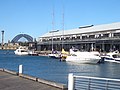 Pyrmont wharves
 -
 Sydney as seen from Pyrmont at dusk
 -
 View from Pyrmont Park at sunset
 -
 Pyrmont Power Station, before demolition
 -
 Sydney Fish Markets


References
- ^ The Book of Sydney Suburbs, Frances Pollon, (Angus and Robertson) 1990, page 213
- ^ www.mustardseed.unitingchurch.org.au
- ^ Early Pyrmont Powerhouse Museum
- ^ Boyce, Francis Bertie (1844 - 1931) Biographical Entry - Australian Dictionary of Biography Online
- ^ The Heritage of Australia, Macmillan Company, 1981, p.2/88
- ^ The Heritage of Australia, p.2/86
- ^ The Heritage of Australia, pp.86-88
- ^ The Heritage of Australia, p.2/88
External links
Template:Mapit-AUS-suburbscale
- From heaven to hell in one easy walk
- Paradise, Purgatory and Hellhole: a history of Pyrmont and Ultimo
- [1]Ultimo + Pyrmont a decade of renewal