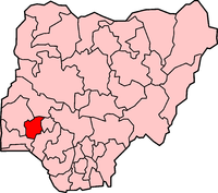
Osun State
| Ọsun State State nickname: State of the Living Spring | ||
| Location | ||
|---|---|---|

| ||
| Statistics | ||
| Governor (List) |
Olagunsoye Oyinlola
(PDP) | |
| Date Created | 27 August 1991 | |
| Capital | Osogbo | |
| Area | 9,251 km² Ranked 28th | |
| Population 1991 Census 2005 est. |
Ranked 17th 2,203,016 4,137,627 | |
| GDP (PPP) -Total -Per Capita |
2007 (estimate) $7.28 billion[1] $2,076[1] | |
| ISO 3166-2 | NG-OS | |
Osun State is an inland state in south-western Nigeria. Its capital is Osogbo. It is bounded in the north by Kwara State, in the east partly by Ekiti State and partly by Ondo State, in the south by Ogun State and in the west by Oyo State. The state's current governor is Olagunsoye Oyinlola, who was elected in 2003 along with his Deputy Governor, Erelu Olusola Obada. Osun State is home to several of Nigeria's most famous landmarks, including the campus of Obafemi Awolowo University, Nigeria's pre-eminent institution of higher learning. The university is also located in the ancient town of Ile-Ifẹ, an important early center of political and religious development for Yoruba culture. Other important cities and towns include the ancient kingdom-capitals of Oke-Ila Orangun, Ila Orangun, Ede, and Ilesa.
History

The modern Osun State was created in 1991 from part of the old Oyo State.The state's name is derived from the River Osun, the venerated natural spring that is the manifestation of the Yoruba goddess of the same name.
Oyinlola recently launched and laid the foundation for the groundbreaking of Osun State University with six campuses (Osogbo, Okuku, Ikire, Ejigbo, Ifetedo, and Ipetu-Ijesha) strategically located across the state.
Culture

Every year, adherents and non-adherents of Osun, one of the Orisa (the traditional deities of the Yoruba people), travel from all over the world to attend the annual Osun-Osogbo festival in August. Visitors include nationals of Brazil, Cuba, Trinidad, Grenada, and other nations in the Americas with a significant Yoruba cultural heritage. Annual traditional festivities and invocations of the Osun goddess are held along the banks of the river bearing her name into which she transformed.
Osun-Osogbo Grove, the shrine of the annual rites of the deity and an important artistic center, was declared a World Heritage Site in 2005.
Demographics
The majority of the people in Osun State are Ifes, Ijeshas and Osuns of the Yoruba tribe, although there are also people from other parts of Nigeria. Yoruba and English are the official languages.
Administrative divisions
Osun State is divided into three federal senatorial districts, each of which is composed of two administrative zones. The state consists of thirty Local Government Areas, the primary (third tier) unit of government in Nigeria.
Osun State's 30 Local Government Areas are listed below with their headquarters in parentheses:
|
|
References
- ^ a b "C-GIDD (Canback Global Income Distribution Database)". Canback Dangel. Retrieved 2008-08-20.
