Patchewollock
| Patchewollock Victoria | |
|---|---|
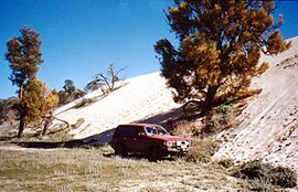
 "Snowdrift" sandhill on otherwise flat land in Wyperfeld National Park, west of Patchewollock, 2001 | |
| Population | 332 (2006)[1] |
| Postcode(s) | 3491 |
| Location | |
| LGA(s) | Shire of Yarriambiack |
| State electorate(s) | Mildura |
| Federal division(s) | Mallee |
Patchewollock is a small town in North-West Victoria, Australia. It was first established after the First World War when soldier settlement blocks were appearing in the area. A Post Office (originally a Receiving Office) opened on July 27, 1920 [2] At the 2006 census, Patchewollock and the surrounding area had a population of 332.
The town maintains a pub and a post office.
The name Patchewollock originated from two Aboriginal words: "putje", plenty, and "wallah", porcupine grass. [3]
Patchewollock is located at 35°22'57.89"S 142°11'22.27"E. Snow Drift (as displayed) is located at 35°25'17.07"S 141°55'56.99"E. The sand-dunes and the ancient lake-bed are easily visible using Google Earth.
References
- ^ Australian Bureau of Statistics (25 October 2007). "Patchewollock (State Suburb)". 2006 Census QuickStats. Retrieved 2007-10-01.
- ^ Premier Postal History, Post Office List, retrieved 2008-04-11
- ^ Shire of Yarriambiack Council

